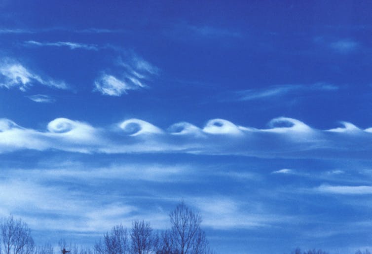
Large Scale Wind Structures
Earth’s landscape provides rock-solid evidence it is the result of electric circuitry, stimulated by some outside force that caused massive discharges. The discharges, however, did not occur as giant sparks jumping from one planet to another, as many EU theorists would lead you to believe. The Earth is, itself a circuit, and the discharges were modulated by capacitance in its layers of crust and atmosphere.
Earth is a transformer, in one aspect, and a capacitor in another. The internal transformer inducts current and raises voltage in the Earth’s electric field; and outer layers of exosphere, thermosphere, mesosphere, stratosphere, troposphere, lithosphere and asthenosphere provide capacitance, which stores and releases energy.
If the ambient voltage around Earth is changed, the internal voltage of Earth must also change in mirror fashion, because it is all one with the circuit of the Sun. As Above, So Below.
When change takes place in the Solar System, from say a large CME, or a planet out of place, the Earth must also enter a transient phase of adjustment to balance it’s internal circuits.
In a transient phase, Earth either has to store energy, or release it from its capacitor plates. In either case, it ramps up the currents in Earth’s circuits. When Earth’s crust releases energy, we call it a volcano. And when the atmosphere releases energy, we call it weather.
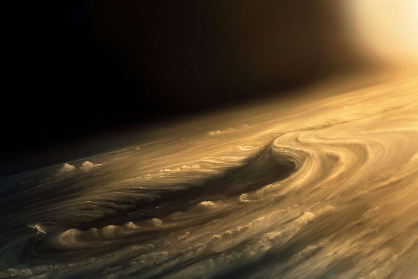
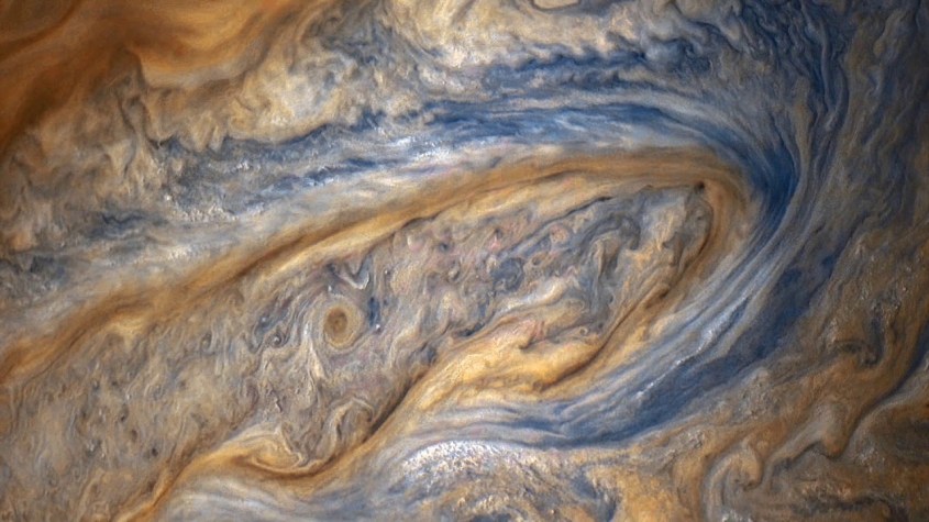
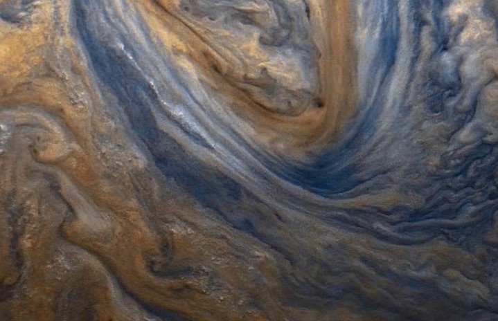
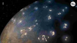
In primordial times, the environment Earth was in went through dramatic transient phases. When this happened, both land and atmosphere went into upheaval, creating an atmosphere best represented today by Jupiter’s. Fractal patterns of motion, heat and diffusion on Earth’s landscape match the cloud patterns on Jupiter in a fashion that can leave no doubt. It’s because the same actions of induced current flow and capacitance is taking place on Jupiter now, in the manner Earth experienced in it’s creation.
We can view these patterns at every scale and find they add up to a coherent picture of the physics behind them. Let’s now examine some of the best examples, starting large and then focusing down.
Mountain Arcs
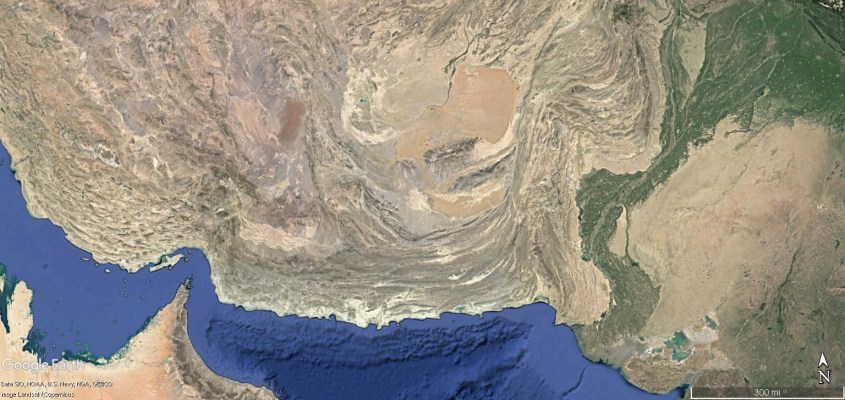
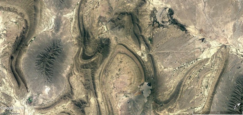
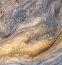
Look at the following patterns of mountain ranges in Siberia, Europe and sand dunes in Saudi Arabia. Then look at the cloud formation on Jupiter and you will see a similar pattern. This pattern repeats everywhere in the clouds of Jupiter. In both cases, the pattern is formed by an up-welling flow of winds in a shear zone of turbulence.
These are the interface zones between circulating winds – dust laden, ionized winds flowing at near, or above Mach speed. The mountains were swept into these sinuous strands, hardened and fused by ionized matter recombining, and the radiation and pressure from an intense fire in the sky, as lightning carpet bombed the rising piles of charged earth.
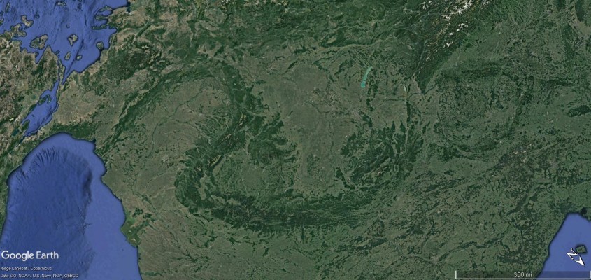

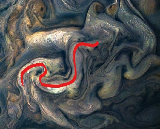
They all follow the shape of a dragon, as do Jupiter’s clouds which display the sinuous shape of the shear zones, where a towering cloud top forms the anvil of a thunderstorm along the up-welling electric winds. The primary motion of Jupiter’s most turbulent winds are up and down, so the cloud tops of the most prominent updrafts display the motion throughout the column, all the way to the planet surface.
What the “surface” of Jupiter is, I don’t know, but it isn’t what we have here on Earth. Maybe it is a super-fluid of hydrogen liquid, or maybe it’s not. Planetary scientists are pretty much always wrong in their predictions. The chemistry and thermodynamics are completely different, that is certain. The fractal shapes and weather effects comes from internal circuitry and how charge diffuses radially away through spherical capacitance. It doesn’t much matter what it’s diffusing through, as long as there are layers with phase changes to cycle things up and down.
Repeating forms at different scales is proof of a fractal process. The only fractal process we know in this Universe, which effects every aspect of matter, whether organic or not, is the process of charge diffusion in an electromagnetic field. We can call it different things: chemistry, thermodynamics, biology, or quantum mechanics; but the closer we look, it always gets back to one thing – it’s electric.
Consensus science likes to call turbulence chaotic. It is anything but. It takes on fractal, repeating, scalable forms that have strange properties of symmetry. Symmetries can be translational and/or rotational about several axis without disrupting the energy balance. So they’re never exactly identical, but they are always the same in a psychedelic, upside-down, inside-out sort of way. They aren’t chaotic, they are just complex.
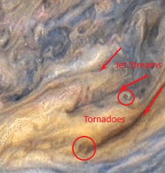
Boundary layers between shearing winds produce series effects like these…..
Parallel currents occur in repeating forms, too. So, there are parallel and series circuits. Gee, it’s just like electricity.
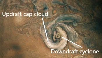
Let’s compare in detail. One spade-shaped feature is almost ubiquitous in Jupiter’s turbulence, and on Earth’s landscape: The ‘boot print’.
On Jupiter, the boot print is the down-drafting eye of a cyclone being pinched in the turbulent flow of competing winds. The cyclone is fed by a filament of high level winds raised by a billowing thunderstorm, which together forms a piece of a circuit – a ring current between the atmosphere and ground – or whatever serves for “ground” on Jupiter. In a sense, it works like an operating amplifier, or Op Amp within the larger circuitry of the planet.
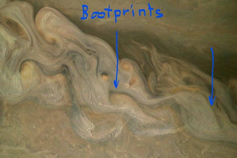
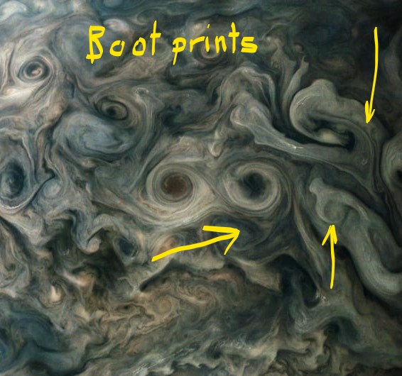
Boot prints on Earth:
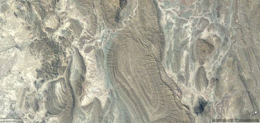
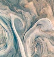
Boot prints on Earth are clear evidence of electric formation, because not only do they have the same fractal shapes as the clouds on Jupiter, they display exactly what is expected in fine detail. The boot print is the consequence of a down bursting wind – as produced by the boot-print cyclones on Jupiter – a hot, ionized, super-sonic, dust laden wind aimed at the ground like a blow-torch.
The mountain rim is the pattern of a standing shock wave. The repeating triangular layers on the inner flanks are impressed there by harmonic shock reflections, which channeled the wind at the boundary layer, and trapped dust in the low pressure zone of triangular wave-forms.
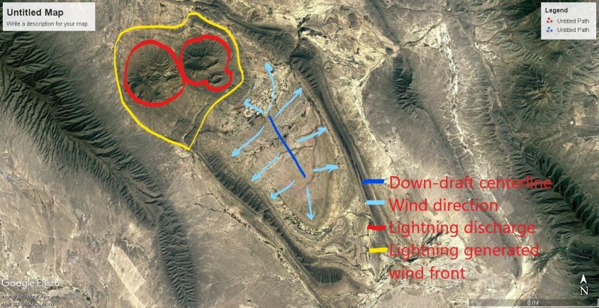
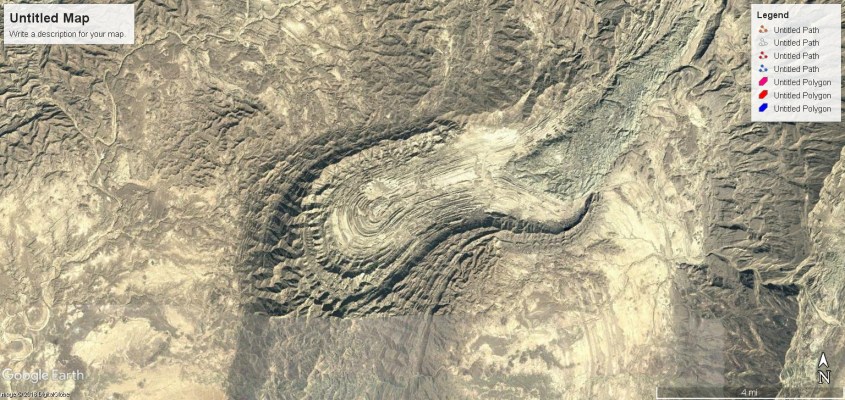
If a down burst wind strikes at an angle, rotates, or its mass flow is biased to one side, it will affect the shape of the crater it forms. Boot prints are accompanied by a feature called a Prandtl-Meyer expansion fan, as shown in this image. It is a series of standing shock waves that form a linear pattern of compression and rarefaction, which implies the boot print is the result of an obliquely striking wind that rotated.
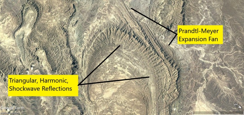
The image above is proof, by the way, of my theory. Anyone with a supersonic wind tunnel can produce a Prandtl-Meyer expansion fan – it’s been done countless times – but find a way to produce it by tectonic uplift, seismic vibration, slip faulting, erosion, meteor strike, or any other conventional geophysical means. Can’t be done. It is uniquely the result of supersonic shock. Nature provides all of my proof.
If you remain a skeptic, at least agree it is not just me saying so – you can see for yourself. The correlation is not only visual similarity, but also the same causation – vertical high speed winds, electrically charged and shaped by electromagnetic fields. Proof of Jupiter’s complex wind flow is in NASA’s data (and I predict it will verify what I say 100%); proof of the effects on Earth is under our feet, and in decades of applied science in supersonic shock-wave behavior (and again, I predict it will agree with me 100%). I’m not even an “expert” and I can figure it out. Proper interpretation of data and some wind tunnel testing would put the issue to bed.
But maybe I can do that with this next example.
California
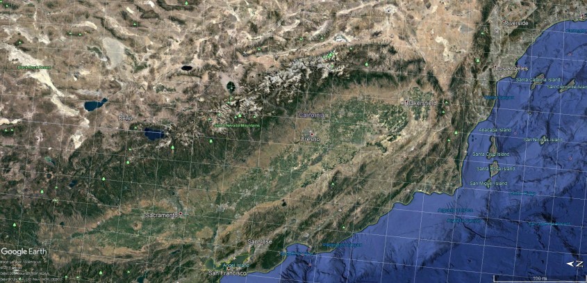
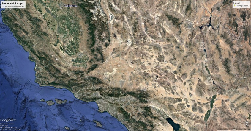
California’s most prominent feature is the San Joaquin Valley and it’s surrounding mountains, including the imposing Sierra Nevada mountain arc. The floor of the valley is a long, flat plain, the elevation only changing from about five hundred to one thousand feet above sea level. It is ringed by mountains, which rise as high as fourteen thousand feet. Essentially, it forms a bathtub, and the floor of the valley is ancient sea bed.
It was created by a storm like this one on Jupiter. So, let’s look at some amazing details.
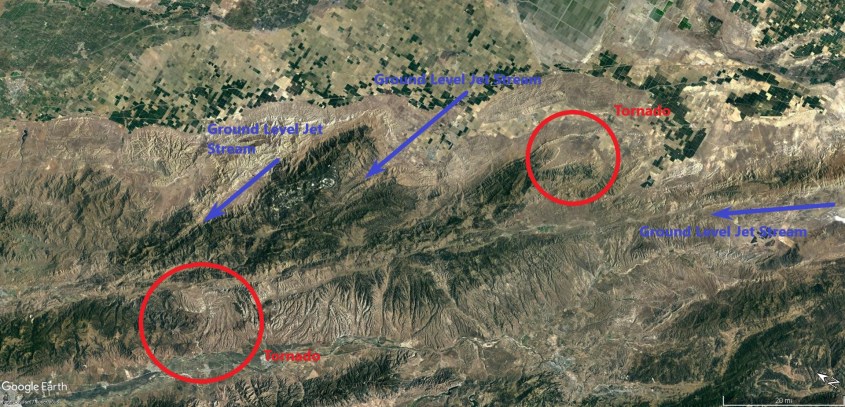
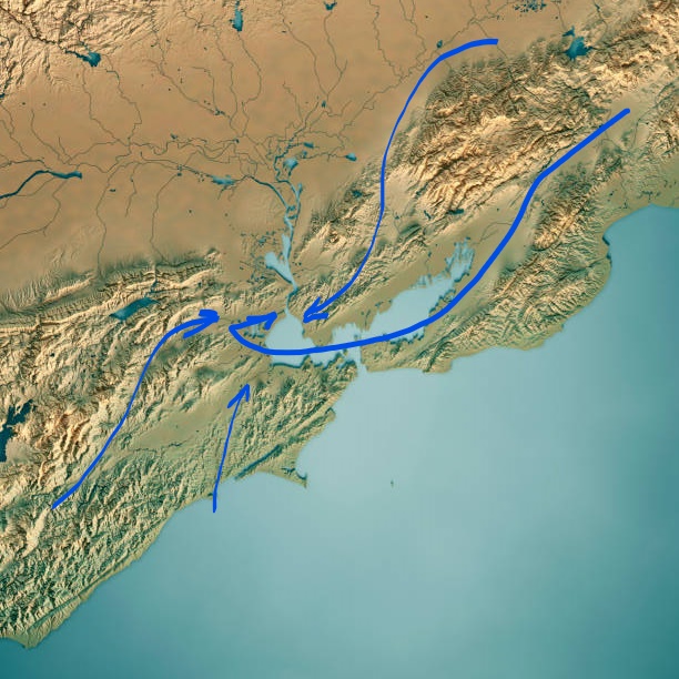
In this image, I indicate four specific areas we’ll discuss.
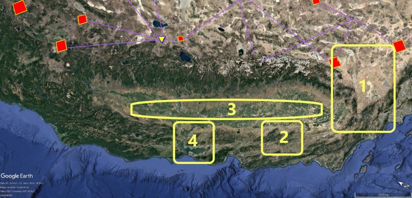
Area 1 – Mojave Desert
This almost perfect triangular plain of high desert is demarcated by the line of the Tehachapi mountains to the north which meet the southern ‘butt’ of the Sierras, and the ruler straight line of San Gabriel mountains to the south, which also aligns with the San Andreas Fault (more about that later).
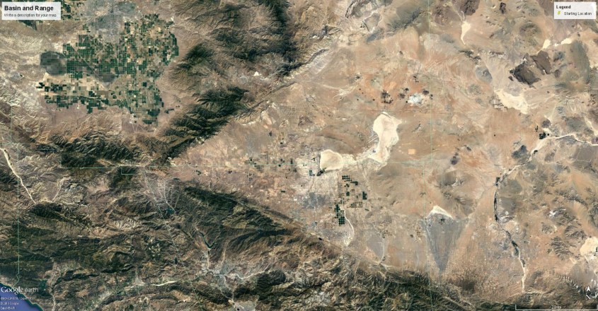
It correlates to the region of low level winds, tinted blue, at the cusp of the oval storm rotation on Jupiter. These winds are sinking winds – that is they are pressing against the ground in a Venturi effect as they speed around the cusp of the storm. You can see the Venturi in the deepest blue triangle below the cusp. The yellow-brown ring of the storm is a rising wind, forming what is essentially a continuous ring of thunderstorms. The sharp triangular demarcation between desert and mountain is the shear zone where shock waves formed between the low level horizontal winds and the rising winds of the rotating storm.
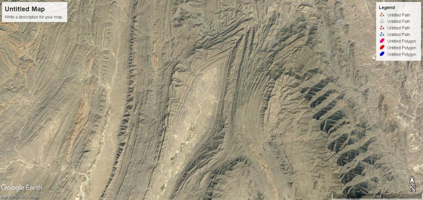
As these winds rounded the corner into the Venturi, (headed toward Ventura, California, coincidentally – or not) they accelerated, gouging the deep Owens, Saline, Amorgosa and Death Valleys. Separating these valleys rise eleven thousand foot ridge lines of the Panamint, Darwin and Amorgosa ranges. They formed as sastrugi, parallel to the jet streams in low pressure interference zones, and their patterns of deposition reflect the conflicting winds that formed them.
Lightning in this region had to be imposing. A plasma intensifies in a shear zone, meaning it generates ion content due to the shearing and extreme temperature and pressure differentials. Shearing supersonic winds bounce shock waves between them, generating the highest current density in jet-streams that extended for thousands of miles. Lightning discharged from these plasma streams focused on the piling mountains below with the capacity of a thousand-mile-long thunderstorm being continually fed new energy.
The current dumped in the strike zone didn’t simply flash a split second, here and there, but arced continuously, diffusing through the land welding granite from dust and sand. That is why the Sierras, in this southern portion of the range, have the most impressive granite structures: Yosemite, Mt. Whitney, it’s neighboring peaks, and the Domes. The granite of the Sierras lies atop sediments, which implies the storm(s), by either wind or tsunami, brought layers of dust before lightning began to strike.
Area 2 – Coalinga
Coaling Station “A” was it’s original name. Coalinga, as it’s called today, is an old California ‘oil patch’ town. The foothills that surround it are oil-fields – anticlines of shallow sandstone saturated in heavy oil. Similar anticlines flank the western side of the San Joaquin Valley, from Coalinga all the way to the southern end of the bath-tub at Bakersfield. These anticlines compose some of the largest oilfields in North America.
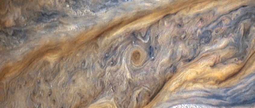
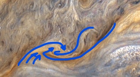
What created them was like this turbulent region in Jupiter’s clouds. The colorized image from NASA shows high level clouds in yellow, and low level clouds in blue, to black. There are several tornado rotations along the boundaries of opposing flows. There are also deep, dark, linear filaments.
Now correlate the dark filaments with the deep cut, linear valleys near Coalinga. The dark filaments are ground level jet streams, which are what formed these valleys by preventing dust from depositing. Follow the filaments on Jupiter and they end in a tornado. Follow valleys through the mountains and they end in hills with spiral features. In other words, the filaments are jet streams hugging the ground, cutting beneath the storm clouds to feed giant tornadoes. Fascinating isn’t it?
I think so.
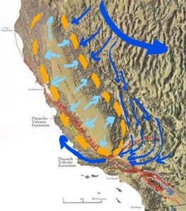
By tracing the wind flows perpendicular to shock fronts, easily identified by the tetrahedron shapes left by shock separation bubbles, a map of ground level winds is produced. High level wind patterns are informed by the cloud structures on Jupiter, which viewed as an energized plasma turbulence makes perfect sense.
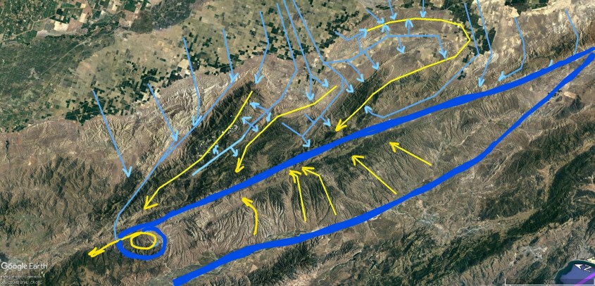
Blue lines represent ground level winds, combing across the San Joaquin Valley, and rising into thunderstorms. Yellow represents the higher level meso-cyclone winds which rained dust and rock. The blue winds approach the thunderstorms orthoganally, then rise in the updraft of the storm. Dark blue lines are the tornadoes and ground hugging jet streams.
It seems chaotic – winds criss-crossing in every direction. But it’s not. The overall structure of wind pattern is called a Kelvin-Helmholtz instability. It happens all the time if there is wind shear. We aren’t informed of the three dimensional electro-magnetic patterns because scientists haven’t …. well, you can judge for yourself who is giving this deep thought; who is stupid and who is smart. I’m just here to show some pictures and suggest maybe someone has failed to ask the right questions.
Area 3 – San Joaquin Valley
Look inside the yellow ring of thunderstorms, and it looks like a pin-cushion, pricked with dozens of tiny vortexes. They are tornadoes, or perhaps in the primordial Earth storms, water spouts, because the San Joaquin Valley was likely a sea at the time.
The waterspouts ranged over the Central Valley ocean, each one as large as an entire thunderhead. One large, yellow rotation occupies the center of the storm. We’ll look at that closer in the next section. Interestingly, though, there are hills full of fossils in the San Joaquin Valley – as if spun into place by such tornadoes. Hills full of sharks teeth that came from ancient, giant megoladon, which provides some indicia for timing the latest storm.
There is other evidence in the region, like the rich gold deposits in the Sierra foothills – but explanations for that won’t be free. Sorry.
Area 4 – San Fransisco Bay
Here, you are literally seeing the drain in the bath tub….Like I said, the San Joaquin Valley is like a bathtub. It’s mountains provide no outlet for air, and the valley is always filled with particulates. I can attest, as my children all suffer respiratory problems from growing up in Bakersfield. We lived there almost two decades.
I also lived in the Bay Area, on the Marin Peninsula. And I lived in Folsom, near the confluence of the American, Sacramento, San Joaquin, Merced and dozens of streams and rivers that co-mingle to create the Sacramento Delta, which feeds the San Fransisco Bay.
As said, this is the drain of the bath tub. Only it sucks up, instead of down. That is what you see on Jupiter as well, in the central vortex, which is yellow, like the surrounding thunderstorms – because they are sucking up whatever that yellow stuff is from below.
On Earth, a similar tornado left dust piled beneath it’s rotation which it drew from the Delta. A drive from Sacramento to Lake Tahoe, on Highway 50 will take you through its footprint.
The vortex sucked out the Delta. It is the lowest point in San Joaquin Valley. Everything slopes down to it, and then it empties into the Bay. The Bay at that time would have been an inflow. The central tornado’s suction pulled wind through the big yellow ring wall of the storm at San Fransisco Bay, creating a complex vortex of high and low level winds.
The physical map of the Delta shows an electrical response on the landscape to what was occurring in the sky. However, ground-to-ground discharges will be a subject for future articles. This essay looks at the wind.
Mountain footprints, valleys and ridge alignments precisely display the motion of the wind. You can look in much finer detail than the broad perspective I annotated here to see correlations in filaments and cloud structures with actual land features in California, as far as possible until pixilation makes the image undecipherable.
What you are seeing is proof. Far more proof than anything presented for plate tectonics, or meteor strikes, or any of the rest of consensus nonsense. I can, and will continue to show examples from around the world that will display reality to you. But go back and look at the images of California. Expand them. Look at them on Google Earth for yourself, and compare to that beautiful image from Jupiter. It’s like seeing a reflection in the mirror.
I’ll just say this to the twit PhD.s. who think they are planetary scientists… Do you really believe what you just saw is a fucking coincidence? Come on…. I can’t wait for some idiot to say so. I have seen, over and over again, this hubris… what is the cause?
Thank you.
Quick Tip
The Daily Plasma is free to read, but the cost of publishing isn’t. Please leave a tip to show appreciation, and help defray expenses.
$5.00
