In my last presentation, Easter egg hunt in the Laramie Mountains, we covered the near perfect cross of canyons made by two out-of-phase circuits coming together. In Part 2, we’ll look at the wind cut valleys around the cross that resulted from induced winds.
Many readers will recall Michael Steinbacher. He theorized landscapes formed by electric winds that prevented deposition of dust raining from the sky. He even performed experiments that demonstrated electric winds doing it. What I’m showing you is exactly what he was talking about.
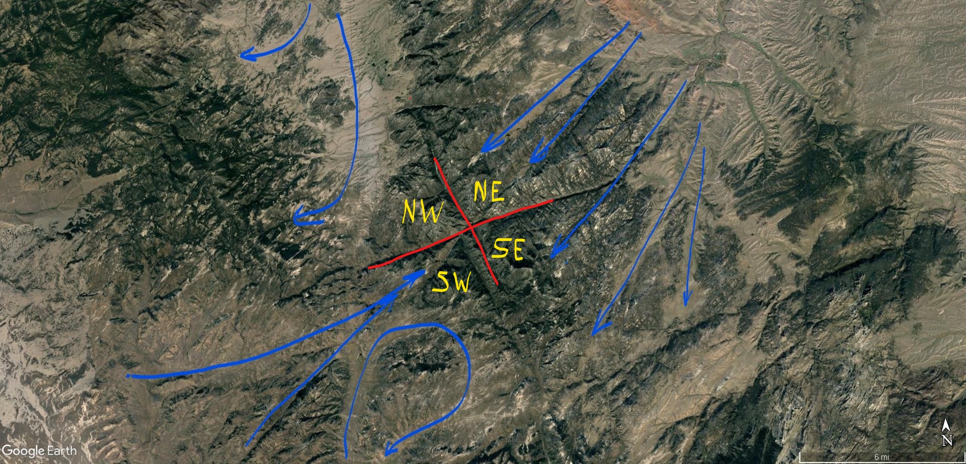
Wind cut channels are sometimes narrow, straight and deep like the capacitive winds in figure 11, and sometimes they snake, divide and join following induction currents, cutting broad valleys with funnel shaped inflows, as shown in Figures 12 through 14. The (a) image is annotated with wind patterns and the (b) image is without markings for comparison.
Winds in the NE quadrant flowed parallel to the SE quadrant winds, and both cut perpendicular to magnetic field lines, but the NE winds shoot inside the loop of magnetic field lines to the apex, whereas the SE winds cut across the loop sideways.
In the NW quadrant, winds followed magnetic field lines, making a sharp bend at the crux of the “X” and staying inside the quadrant, but lifting as they made the turn.
The SW quadrant has a split personality. In one half winds flow straight at the crux of the “X” in direct opposition to wind from the NE quadrant. These winds met in a central updraft that lifted them vertical. In the other half of the quadrant, winds circulate, making an “S” shaped pattern that begins parallel to, and then crosses magnetic field lines perpendicularly.
Figure 12aFigure 12b.
Figure 13a
Figure 13b
Figure 14a
Figure 14b
The reason for winds to flow either parallel to, or perpendicular to magnetic field lines is induction. Both moving magnetic fields and electric fields induce current. Reactive current is called capacitive when it follows electric fields. It is called inductive when it follows magnetic fields. Magnetic fields are perpendicular to electric fields in certain conditions. Since these mountains formed from circuits 180 degrees out-of-phase, things tend to line-up.
The Laramie circuit produced induction currents following both electric and magnetic fields. Winds in the NE quadrant were due to capacitive reactance, following the electric field. The NW quadrant winds were due to inductive reactance, aligned with magnetic field lines. The SW and SE quadrant winds were combinations of capacitive and inductive currents, but expressed in different geometries.
Reactive currents express either inductive, or capacitive behavior, or a mix in different parts of the circuit. Therefore it’s not surprising the southern quadrants have blended currents. What is surprising is how clear the pattern is etched, in spite of all the chaos and violence of this event. On display are electromagnetic forces that stirred the earth, like we would stir iron filings with a magnet.
Further away from the discharge, the southern quadrants mixed into a large tornado with two satellite whirlwinds that lifted wind in this quadrant into the mesocyclone storm (Figure 15). This tornado region sits just south of the “X” which marks the center of the mesocyclone’s central updraft. This position corresponds well with the formation of “wall clouds” that spawn tornadoes in typical thunderstorms.
Figure 15. Both southern quadrants display tornado footprints (violet) and shock waves (green). Blue are ground winds.
Shock waves reverberated absolutely everywhere, creating nearly vertical oriented tetrahedrons layered like fish scales. Shock waves from winds sucking into the maelstrom left triangular wave-forms where separation bubbles formed beneath screaming jet-streams. They display direction of winds that confirms the wind paths described.
Where wind exceeds supersonic speed and is forced to change direction, shock waves form. They are like folds in the fabric of the wind, which is stiffened into laminar jet streams segregated by extreme pressure differentials.
Tornadoes draw ground winds from all directions, but in a supersonic tornado, there is an inlet zone where the majority of wind enters the rotation. They are drawn from ambient jet stream winds that the tornado forms tangent to. Figure 16 shows winds entering the whirlwind change direction from linear to rotation, forming a large shock wave tangent to the rotation, and parallel to the jet stream (note 1). This inflow shock wave is a distinct feature of tornado “footprints” if the winds involved were supersonic.
If the winds also rotated at supersonic speed, additional shock waves form tangent to the rotation at points of shear between the rotating winds and ambient winds (note 2).
Finally, tornadoes may form shock waves due to shearing interior to the rotation where they curl inside the inlet zone (note 3).
Figure 16. Supersonic Tornado Shock Waves
The largest tornado in Figure 15 lies in the SE quadrant and produced Laramie Peak. It’s the highest point in the range at 10,260 ft, and sits next to a gouged-out valley that dips to 6,700 ft elevation. Both the valley and the peak are within the tornado’s rotation. Tornadoes form a cambered debris “bowl” where the winds scrape the ground. The debris is lifted away where the force of inlet winds carve at the land, and then are deposited on the opposite side of the rotation as the winds lift (Figure 17). Mt. Laramie is one such deposit.
Figure 17. Tornado mountain building.
Shock waves are evident where supersonic winds change direction. Examples in Figure 18a are tetrahedrons formed in the NE quadrant, where winds following the electric field lifted to create separation bubbles. They form tetrahedrons in linear rows conventionally known as monoclines, but they are, in fact, supersonic “sand dunes”. This is especially evident if you examine the breaks and inflections caused by constructive and destructive interference patterns.
Figure 18a shows tetrahedrons formed by jet stream winds rising to the mesocyclone in Area 1. A new set of tetrahedral dunes formed in Area 2, which deflected winds and starved Area 3, leaving a triangular interference zone that pinched out formation of tetrahedrons from the shock wave of Area 1. The gap between Areas 1 and 2 turned the wind and formed a tornado (Area 4) in it’s eddy.
Figure 18b shows these same features from another angle and how eddy currents form behind tetrahedrons in a low pressure zone beneath the rising winds. These are, in effect, destructive interference troughs behind the constructive peak of the wave pattern as winds undulated across the ground.
Figure 18a. Shock waves are green; wind direction, blue; destructive interference, orange; and tornado, violet.Figure 18b. Shock waves green; wind direction, blue; wind eddies and tornado in violet.
Stepping back to look at the entire heart-shaped circuit domain in Figure 19; blue lines trace the ground level jet stream winds, violet swirls indicate where tornadoes made definitive features on the ground, red “x”s are discharge patterns, and the green areas are where the thunderstorms down-drafted to the rear and rear flank of the storm (also Figure 20). The two lakes are where the circuits connected to ground deep in the Earth, leaving a distinct “V” shaped land form between them forming the base of the “heart”.
The top of the heart is an accumulation of positively charged matter swept there by winds in-flowing to meso-cyclone updrafts, and the bottom of the heart is a negatively charged basin swept clear by down-drafting winds. These are the anodic and cathodic sides of the domain, neatly separating the top and bottom of the heart. There are several other symmetries and heart analogies hidden there.
Figure 19. Laramie Mountains wind flow pattern. Blue lines are ground wind paths, Violet swirls are tornadoes, Green outlines storm downdrafts. Two other “X” shaped discharges are shown to the SE of central discharge.Figure 20. This basin is the center of down-burst winds from the meso-cyclone. Note the massive erosion and deep, wind cut canyons.
This would have been a horrible place. The discharges blasted negative ions and free electrons away in arc blasts, while drawing positive ions inward. The velocities, temperatures and densities of the winds differed, their dielectric properties differed, their charge densities differed; and they segregated, with the positive inflow hugging the ground, accumulating dust that adhered to the statically charged land. The drag of the winds covered the land with blankets of dust, layered like fish scales, hardened by sonic pressure and electric currents that snapped and crackled everywhere.
The clouds roiled in whirling updrafts overhead. A squall-line of heavy thunderstorms formed in mirror image to the chaos on the ground, spitting lightning in carpet bomb fashion that would have made the clouds glow. Rain fell in torrents of mud and rock. Supersonic winds scoured the ground, in-flowing to biblical whirlwinds, and sonic shock waves reverberated in electrified sheets of plasma current; the entire atmosphere surrounding the storm patterned in the shock-diamond herringbone of flashing, ionized shock waves.
Lightning discharge blossomed like acne, leaving pinnacles, dikes, craters and domes in regions of high tension. Winds stirred around these discharges, disturbing the ambient winds into transient cyclones that left hardened dunes as monuments. And the winds reached supersonic speeds patterned by shock waves that embossed the land with triangular and polygonal wave-forms.
At the time they were made, with all the violent turbulence, heat and electric currents, the mountains likely resembled not so much hard granite, but puddles of hot jam, squished into form by wind and mashed by an electric fork.
Figure 21. Laramie Mountains.
This whole mountain range is direct and unequivocal evidence of electric formation. Conventional means of uplift, faulting and erosion requiring several eons of disconnected events could not, by any reasonably statistical probability produce phase diagrams 15 miles across the face of the earth with induced current paths shaped by magnetic field lines.
The features of these mountains are coherent only when recognized as the result of electrical circuits in the Earth. Each ridge line and canyon, every hill and dale, can be tied to a sequence of events that occurred at one particular phase in Earth’s evolution involving extreme electrical stress on the planet.
Conventional science can’t explain why any two of these features coexist, let alone demonstrate their disjointed theories empirically, or model them with any real plausibility on computers. But you can make discharge patterns like this with some wire and an AC power source. Or, as I have done, bring two out-of-phase plasma balls into contact.
I simply powered one plasma ball with AC current and one with DC, so it produced and in-phase/out-of-phase sequence as the AC side alternated. Between the two balls, the sparks joined and spread with each pulse, like hands clasping, then spreading fingers to push away as energy expended in reactive discharges, perpendicular to the in-phase current flow, just like the “X” patterns in the mountains.
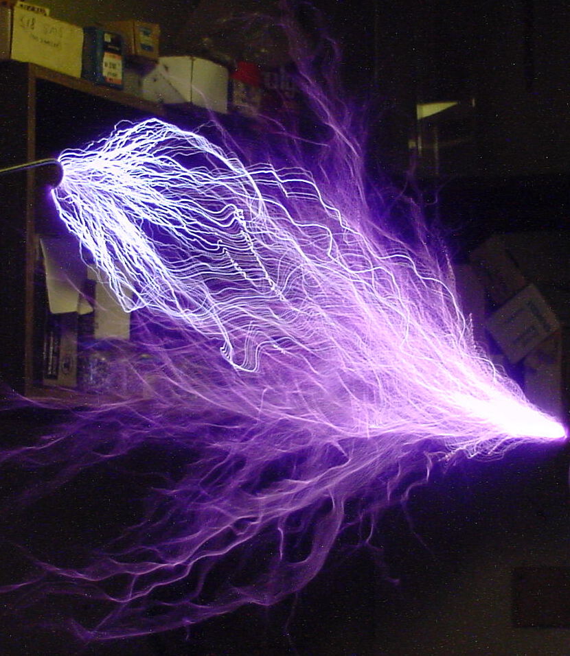
The plasma interaction between the plasma balls didn’t occur at the glass barrier of the globes, as you might expect. It occurred inside the DC ball with the weaker voltage, pushed there by the higher voltage AC ball. Unfortunately, the experiment fried my plasma balls before I could film it. I don’t have the kind of high speed equipment needed to properly photograph it anyway. This image in Figure 21 however, does capture the effect, although I don’t know the circuitry of this set-up.
Figure 22. Tesla coil discharge (white filaments) makes connection with an electrode. Reactive power currents (violet flames) spread in a cone around the discharge.
Figure 21 shows a Tesla coil discharging to an electrode. White filaments of current direct connect to the electrode, while violet plasma flames of reactive power shoot outward in a cone around the discharge. The angle of the cone isn’t 90 degrees, but that is an artifact of this particular circuit and its phase angle.
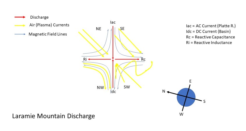
The Laramie circuit resulted in a discharge along a dipolar alignment between circuit domains, with a capacitive reaction aimed clockwise 90 degrees from the dipolar alignment, and an inductive reaction 90 degrees counter-clockwise, forming a cross, because the domains were exactly 180 degrees out-of-phase.
So, you see the world is a more understandable place than you have been led to believe. To understand it we need to recognize the Earth contains holographic imagery of it’s past charge distributions. We need to recognize that charge distributions result from circuitry that can be traced, understood and put to experiment and modelling. The information is there to learn vastly more than we know today about its creation. To get the info, we just need to ask the right questions.
In the final chapter of the Eye of the Storm series I presented Easter eggs – surprise geologic findings that confirmed a theory, or presented astonishing new information about Earth’s electric circuitry. Exploring the Electric Earth is a perpetual egg hunt, because every rock confirms the Bunny is REAL.
Electrical discharges follow patterns and behaviors that yield definitive information about cause and effect. Discharge patterns on the landscape indelibly record discharge events, like a holographic data bank.
Chapters 8 and 9 of Eye of the Storm discussed surface conductive discharges across Earth’s surface that formed the Colorado River and it’s tributaries. The trace of a surface conductive discharge is particularly rich in information, because, unlike a lightning bolt that momentarily sticks on the Earth, a surface discharge has to crawl across the surface, meeting significant impedance, seeking out conductive pathways, expending vast energies transporting matter, while explosively faulting and excavating. It takes time, it’s not energy efficient and it leaves its mark.
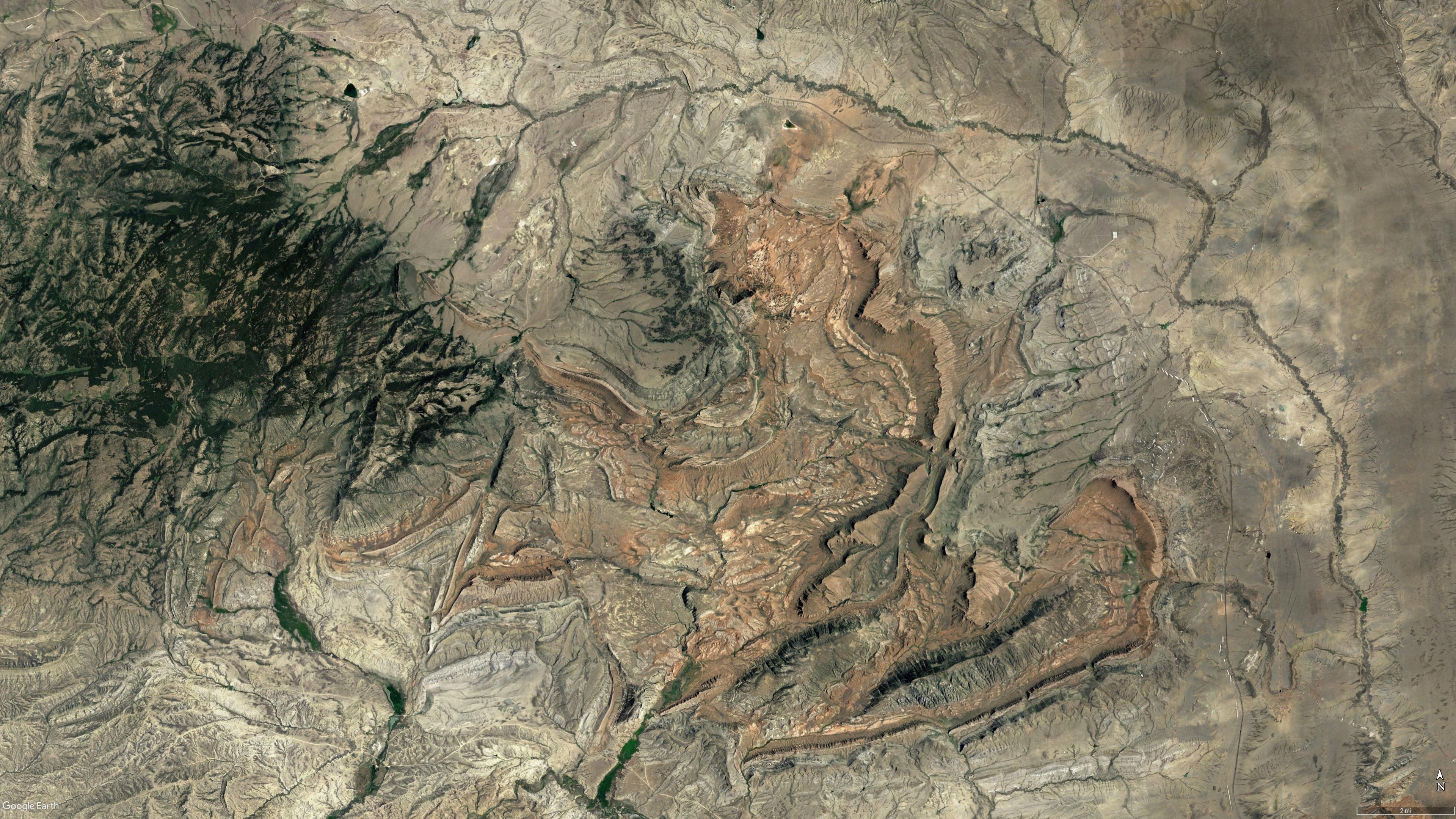
A stunning display of a particular type of surface conductive discharge can be found in the Laramie Mountains in Wyoming (Figure 1). Embedded in these mountains are gorges and ridge-lines that literally form a phase diagram of what took place. It couldn’t be more explicit than if God had left his blueprint on the drafting table for all to see. This fifteen mile cross is from a discharge between two out-of-phase circuits.
Figure 1. “X” marks the spot, smack in the center of the Laramie Mountains.
First, however, let’s consider the geometry of a surface conductive discharge. Each discharge branches out in fractal, self similar dendrites, to absorb all the surface charge on the conductive object it’s attached to (Figure 2a) – in our case it’s the Earth. This is diffusion limited aggregation. Each filament of a discharge soaks up charge from a particular domain. The domain is a region surrounding the spark defined by it’s electromagnetic field, from which it sucks charge of one polarity and spits charge of the other polarity in reactive power surges. It does this because it’s not insulated current like we use in electrical systems.
Figure 2a. Filament Domains
Figure 2b. Domain Boundaries.
Filament domains cover every square inch of solid land on the planet. We call them watersheds, because they serve to collect rain waters into river channels, but that’s a consequence, not a cause. The Earth once crawled with electrical discharges. This should be self evident in any theory of planetary formation. In consensus theories, planet and comet collisions would necessitate big sparks. In Electric Universe theory, sparks are already acknowledged. Why consensus science doesn’t look for evidence of electrical discharge is evidence they don’t ask the right questions.
What is interesting – the big Easter Egg I’m getting to – is that domains cross and the filaments interact. Giant sparks result. The interaction we’ll investigate created a landscape that can only be explained electrically. The statistical probability of consensus theories doing it is nigh impossible.
Domains don’t usually cross, because skin effects occur between domains that keep them segregated as if by a membrane (Figure 2b). But they can cross and interact if domains are out of balance. An over-voltage in one could make it aggressive and overcome another. Depending on phase disparities, this can be a gentle hand holding connection, or it can be an explosive punch. We will look at one of the explosive kinds.
The Laramie Range – Shot Through The Heart
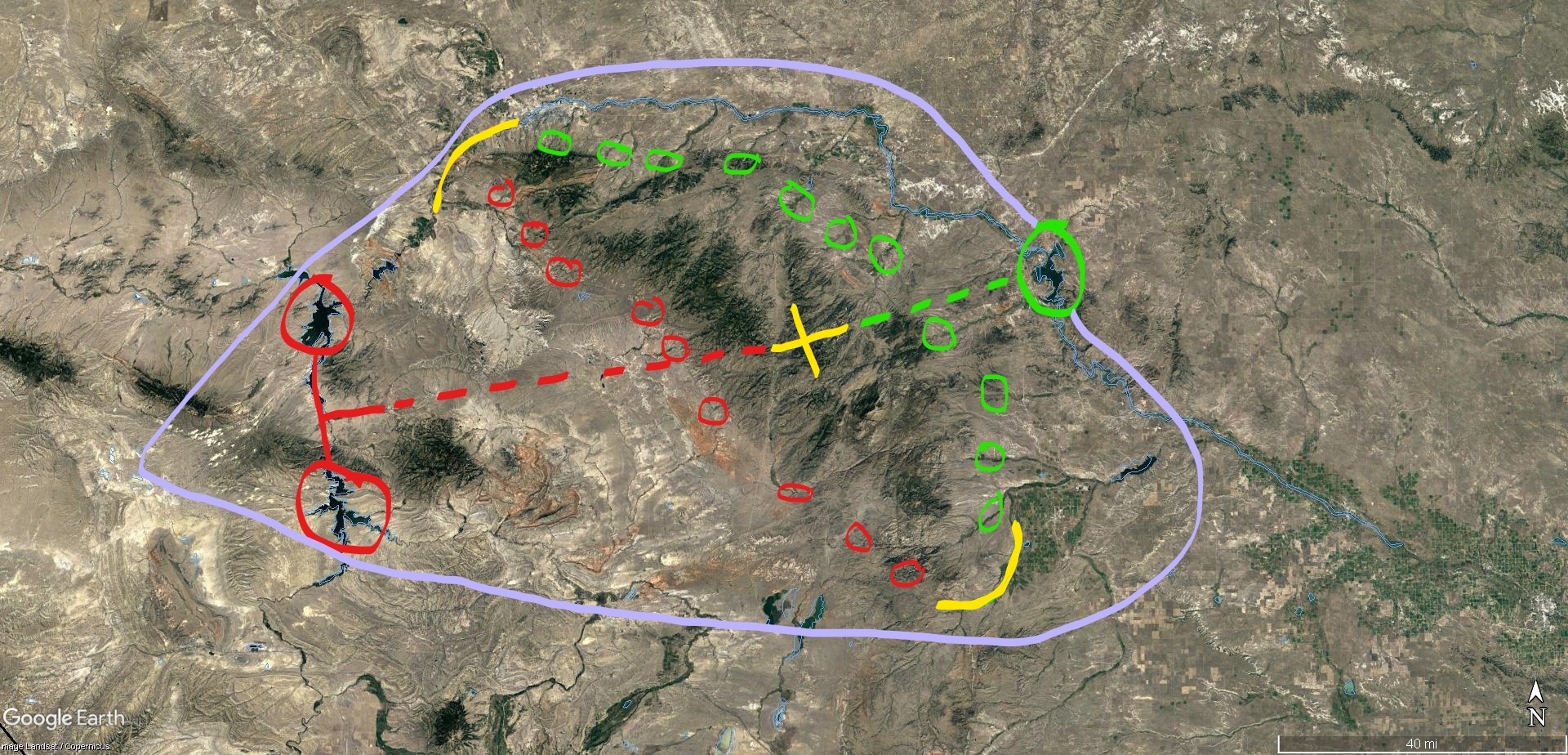
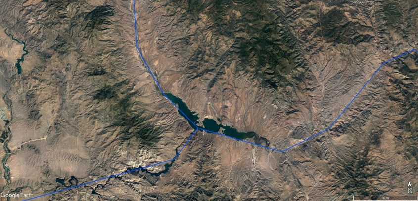
The annotated image in Figure 3 shows the area of interest, circled in violet, including the Laramie Mountains surrounded by green and red circles. The Laramie’s are part of the Continental Divide as it cuts through south-eastern Wyoming. The circles denote the major streams flowing from the mountains. Green are streams flowing to the North Platte, and thence to the Missouri and ultimately the Mississippi Valley and the Gulf of Mexico. Red are streams that flow to a sink in the basin west of the mountain range. The sink forms the Seminoe and Pathfinder Reservoirs, also circled in red west of the mountains, and the North Platte River forms the Glendo Reservoir on the opposite side, circled in green.
The high basin drains around the mountains in two flows (yellow connections). North Platte runs near Casper Wyoming around the north of the mountains, and the Laramie flows from Medicine Bow to Fort Laramie through a pass to the south of the range. The overall structure is shaped like a heart, with the mountains filling the upper half, the basin filling the lower and the rivers acting as arteries and veins.
Figure 3. Laramie Mountains circuit domain forms a Heart.
“X” Marks the Spot
The distinctive yellow “X” in the center of the range in Figure 3, is a discharge pattern that occurred when the North Platte filament of the Mississippi discharge met a separate domain with a different phase. What you see is literally a natural phase diagram that records the phase angles of the discharge. The discharge took place because the Missouri circuit was an AC current that made connection to a ground current in the basin, and sparks shot between the circuits where their domains came together. The Laramie Mountains formed as a consequence.
The discharge adopted an “X” pattern where it made connection, with east-west branches vectored along the electric field denoted by the dotted red and green lines in Figure 3. The electric field is the dipolar alignment between the lakes. The lakes, or the depressions where these lakes are, were created in the same discharge event that met at the crux of the “X” and sent reactive discharges rotated at 90 degrees to the originating spark between the circuit domains. The discharge is much like the “resonant frequency discharges”, discussed in Chapter 8 and 9 of Eye of the Storm, which created the major 180 degree (or nearly so) branches of the Colorado (Figures 4).
Gila Bifurcation
Lake Powell Bifurcation
Lake Meade Bifurcation
Roosevelt Lake Bifurcation
Figure 4. Resonant frequency discharges bifurcate current into Inductive and capacitive reaction currents.
The geometry is different, an “X” instead of a “T”, but that is because the “X” is a resonant discharge between two existing circuit domains, whereas the “T” is a result of a single circuit bifurcating.
The bifurcating discharge meets critical resistance due to a build-up of stray capacitance that resonates the circuit, increasing frequency and therefore resistance until the current is stopped, causing it to explode in reactive discharges 90 degrees to either side of the original current, as shown in Figures 4.
The “X” is produced by two out-of-phase circuit domains coming together. The Missouri circuit is an alternating current, whereas the basin circuit is a direct current-to-ground. The two circuits go in and out of phase with each other as the AC current alternates. This makes a connection, then a discharge. The discharge is totally in the reactive power mode, because the out-of-phase circuits are 180 degrees out-of-phase and that has the same effect as resonant discharge, raising resistance to infinity and forcing the current out sideways at 90 degrees.
The first case is like putting a finger over the nozzle of a hose and forcing water to spray out sideways, 90 degrees to the direction of the nozzle. The second case is like having two hoses aimed at each other, and where the streams impact, flow sprays out sideways. In one, the blocked water pressure changes flow direction and makes a “T”, and the other, two flows impact and the pressure changes flow direction to make an “X”.
The reactive discharge dissolves the voltage differential between circuits by expending their charge – the entire accumulated charge in the Missouri circuit, in this case – in an explosive “X” shaped spark.
It created what astrophysicists call “magnetic re-connection”. Astrophysicists don’t recognize electric circuitry in space because, in dark mode, current doesn’t emit radiation they can detect. Since they can’t see it, their reductionist minds can’t make the intuitive leap to circuitry, but they do detect the magnetic flux that results. They invented the term “magnetic reconnection” in lieu of an explanation, because they can’t fathom the simplicity of two out-of-phase circuits coming together to make a spark.
Figure 5 is a .gif of “magnetic re-connection”. The moving lines are magnetic field lines – the things astrophysicists think are re-connecting – but they are actually the magnetic field lines generated by current flow oriented along the dotted lines. Their model only recognizes magnetism, so the dotted lines are just separators of the magnetic field in their .gif. The big yellow arrows pointed inwards and outwards in different quadrants of the “X” are the vectors of electric current induced by the changing magnetic field.
In the Laramie’s, induced currents were expressed in the atmosphere by plasma winds. Plasma winds drew to the crux of the discharge at ground level in the top and bottom quadrants, and blew outwards at high level like an anvil cloud in the right-left quadrants. The winds lifted in a vertical updraft over the center of the “X”. But even more astounding is the effect that magnetic fields and reactive currents had shaping the entire basin and range structure. The landscape is a 3-D photograph of what happened.
Figure 5. Magnetic field lines in “magnetic reconnection” event.
To appreciate what took place, the three dimensional nature of the circuit domains needs to be recognized. Charge diffused across the ground, as well as through the ground and into the sky. Capacitance between the Earth and sky forced mirroring currents in the atmosphere, stirring a violent storm system. Think of it as a local squall line of thunderstorms raging over the mountains at the time they were formed and while the ground discharge took place. The central updraft over the “X” formed a huge mesocyclone, flanked by smaller thunderheads to either side. Most of the energy of the discharge went straight up, into the meso-cyclone, pulsing it with energy. The wind paths to be described are ground level winds, shaped by the electromagnetic field at the planet’s surface.
The combined effect of the discharge at ground level, it’s magnetic field and the resultant plasma winds are shown in Figure 6. The discharge makes the “X” pattern, shown in red. The magnetic field lines (blue) are as shown as in Figure 5 in the pattern of “magnetic reconnection”. The wind vectors are shown in yellow.
Figure 6. Laramie Mountains – discharge currents, magnetic flux and induced winds.Figure 7. Wind cut valleys surround the discharge “X”, patterned by capacitance and magnetic induction.
Figure 7 shows how these winds patterned around the “X”. The winds in the NE and SE quadrants flow parallel. In the NE, they cross magnetic field lines perpendicularly, flowing straight to the crux of the discharge. These winds were narrow jet streams that cut valleys as shown in Figure 8.
Figure 8. Parallel wind cut valleys in the NE quadrant. Wind lifts into central updraft at upper end of valleys where it intersects the discharge.
Jet stream winds leave valleys like shown in Figure 8, with broad rounded, or “V’ cut bottoms carpeted with silt, but no inner gorge. They may have superficial, meandering stream erosion, but not a deep, straight, inner gorge. We’ll examine more wind cut valleys later, but first let’s distinguish between wind cut valleys and the discharge blasted canyons that form the “X”.
The path of a discharge leaves canyons rough cut, with a deep inner gorge like shown in Figure 9. This is the Platte River, or north-eastern arm of the “X”.
Figure 9. NE Quadrant (Platte River side) discharge canyon has deep inner gorge.
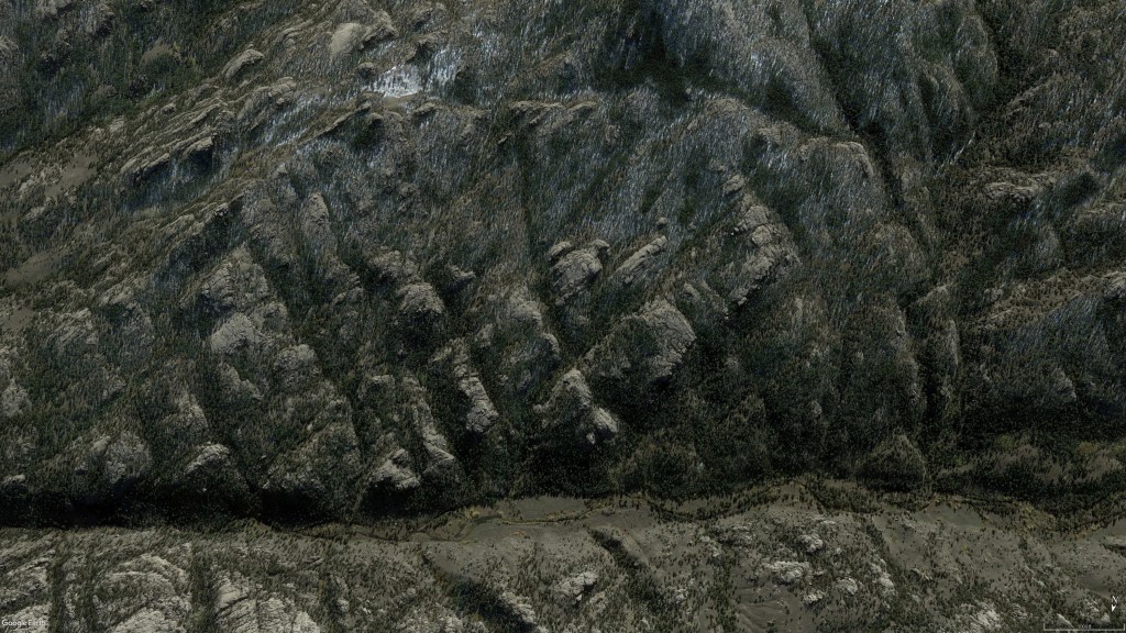
The sides of the discharge canyon indicate arc blast which exposed granite tetrahedrons. On one side the tips of tetrahedrons (leeward side) jut out, exposed and broken (Figure 10b), whereas the other side shows the flat faces of windward tetrahedrons (Figure 10a). This indicates the mountains were laid down by a cross-wind before the discharge occurred and blasted this canyon. So, the mountains resulted from an evolving storm system that changed it’s winds, surely due to this big spark. Note the cross-hatch patterns of shock diamonds in the canyon flanks.
Fig 10a. Discharge cut through tetrahedrons (west side).
Fig.10b Tetrahedron tips jut from east walls of discharge canyon.
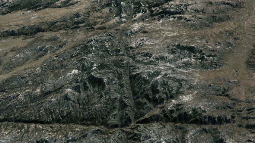
Figure 11 shows NE quadrant wind-cut valleys between north and east arms of the “X” discharge. Note the many transverse striations of cuts and gorges and how they change orientation between arms of the discharge. Striations come from deposition layers shaped by shock waves transverse to winds, and secondary discharge filaments between circuit paths.
Winds drew into a central vortex at the crux of the discharge, drawing dust into a pile to form the mountain. Therefore each quadrant of the discharge displays shock waves oriented by the wind in that quadrant.
Secondary discharges are from short circuiting sparks between current paths, like sparks between live, bare wires that are too close together. There is one secondary discharge visible that makes it’s own “X” pattern, center right in the image. This is a mini discharge between the AC current in the big “X” and the static build-up of charge in the wind cut lane due to the plasma jet stream. It’s essentially an AC to DC connection that makes a perfect 90 degree reaction just like the big “X”. It’s even in the same orientation – repeating, self similar forms.
Figure 11. NE quadrant parallel jet streams aimed at crux of discharge.
In the next article we’ll return to look at more wind-cut valleys in the Laramie Mountains of Wyoming, and how they were shaped by electromagnetic forces.
In the final chapter of the Eye of the Storm series I presented Easter eggs – surprise geologic findings that confirmed a theory, or presented astonishing new information about Earth’s electric circuitry. Exploring the Electric Earth is a perpetual egg hunt, because every rock confirms the Bunny is REAL.
Electrical discharges follow patterns and behaviors that yield definitive information about cause and effect. Discharge patterns on the landscape indelibly record discharge events, like a holographic data bank.
Chapters 8 and 9 of Eye of the Storm discussed surface conductive discharges across Earth’s surface that formed the Colorado River and it’s tributaries. The trace of a surface conductive discharge is particularly rich in information, because, unlike a lightning bolt that momentarily sticks on the Earth, a surface discharge has to crawl across the surface, meeting significant impedance, seeking out conductive pathways, expending vast energies transporting matter, while explosively faulting and excavating. It takes time, it’s not energy efficient and it leaves its mark.
A stunning display of a particular type of surface conductive discharge can be found in the Laramie Mountains in Wyoming (Figure 1). Embedded in these mountains are gorges and ridge-lines that literally form a phase diagram of what took place. It couldn’t be more explicit than if God had left his blueprint on the drafting table for all to see. This fifteen mile cross is from a discharge between two out-of-phase circuits.
Figure 1. “X” marks the spot, smack in the center of the Laramie Mountains.
First, however, let’s consider the geometry of a surface conductive discharge. Each discharge branches out in fractal, self similar dendrites, to absorb all the surface charge on the conductive object it’s attached to (Figure 2a) – in our case it’s the Earth. This is diffusion limited aggregation. Each filament of a discharge soaks up charge from a particular domain. The domain is a region surrounding the spark defined by it’s electromagnetic field, from which it sucks charge of one polarity and spits charge of the other polarity in reactive power surges. It does this because it’s not insulated current like we use in electrical systems.
Figure 2a. Filament Domains
Figure 2b. Domain Boundaries.
Filament domains cover every square inch of solid land on the planet. We call them watersheds, because they serve to collect rain waters into river channels, but that’s a consequence, not a cause. The Earth once crawled with electrical discharges. This should be self evident in any theory of planetary formation. In consensus theories, planet and comet collisions would necessitate big sparks. In Electric Universe theory, sparks are already acknowledged. Why consensus science doesn’t look for evidence of electrical discharge is evidence they don’t ask the right questions.
What is interesting – the big Easter Egg I’m getting to – is that domains cross and the filaments interact. Giant sparks result. The interaction we’ll investigate created a landscape that can only be explained electrically. The statistical probability of consensus theories doing it is nigh impossible.
Domains don’t usually cross, because skin effects occur between domains that keep them segregated as if by a membrane (Figure 2b). But they can cross and interact if domains are out of balance. An over-voltage in one could make it aggressive and overcome another. Depending on phase disparities, this can be a gentle hand holding connection, or it can be an explosive punch. We will look at one of the explosive kinds.
The Laramie Range – Shot Through The Heart
The annotated image in Figure 3 shows the area of interest, circled in violet, including the Laramie Mountains surrounded by green and red circles. The Laramie’s are part of the Continental Divide as it cuts through south-eastern Wyoming. The circles denote the major streams flowing from the mountains. Green are streams flowing to the North Platte, and thence to the Missouri and ultimately the Mississippi Valley and the Gulf of Mexico. Red are streams that flow to a sink in the basin west of the mountain range. The sink forms the Seminoe and Pathfinder Reservoirs, also circled in red west of the mountains, and the North Platte River forms the Glendo Reservoir on the opposite side, circled in green.
The high basin drains around the mountains in two flows (yellow connections). North Platte runs near Casper Wyoming around the north of the mountains, and the Laramie flows from Medicine Bow to Fort Laramie through a pass to the south of the range. The overall structure is shaped like a heart, with the mountains filling the upper half, the basin filling the lower and the rivers acting as arteries and veins.
Figure 3. Laramie Mountains circuit domain forms a Heart.
“X” Marks the Spot
The distinctive yellow “X” in the center of the range in Figure 3, is a discharge pattern that occurred when the North Platte filament of the Mississippi discharge met a separate domain with a different phase. What you see is literally a natural phase diagram that records the phase angles of the discharge. The discharge took place because the Missouri circuit was an AC current that made connection to a ground current in the basin, and sparks shot between the circuits where their domains came together. The Laramie Mountains formed as a consequence.
The discharge adopted an “X” pattern where it made connection, with east-west branches vectored along the electric field denoted by the dotted red and green lines in Figure 3. The electric field is the dipolar alignment between the lakes. The lakes, or the depressions where these lakes are, were created in the same discharge event that met at the crux of the “X” and sent reactive discharges rotated at 90 degrees to the originating spark between the circuit domains. The discharge is much like the “resonant frequency discharges”, discussed in Chapter 8 and 9 of Eye of the Storm, which created the major 180 degree (or nearly so) branches of the Colorado (Figures 4).
Gila Bifurcation
Lake Powell Bifurcation
Lake Meade Bifurcation
Roosevelt Lake Bifurcation
Figure 4. Resonant frequency discharges bifurcate current into Inductive and capacitive reaction currents.
The geometry is different, an “X” instead of a “T”, but that is because the “X” is a resonant discharge between two existing circuit domains, whereas the “T” is a result of a single circuit bifurcating.
The bifurcating discharge meets critical resistance due to a build-up of stray capacitance that resonates the circuit, increasing frequency and therefore resistance until the current is stopped, causing it to explode in reactive discharges 90 degrees to either side of the original current, as shown in Figures 4.
The “X” is produced by two out-of-phase circuit domains coming together. The Missouri circuit is an alternating current, whereas the basin circuit is a direct current-to-ground. The two circuits go in and out of phase with each other as the AC current alternates. This makes a connection, then a discharge. The discharge is totally in the reactive power mode, because the out-of-phase circuits are 180 degrees out-of-phase and that has the same effect as resonant discharge, raising resistance to infinity and forcing the current out sideways at 90 degrees.
The first case is like putting a finger over the nozzle of a hose and forcing water to spray out sideways, 90 degrees to the direction of the nozzle. The second case is like having two hoses aimed at each other, and where the streams impact, flow sprays out sideways. In one, the blocked water pressure changes flow direction and makes a “T”, and the other, two flows impact and the pressure changes flow direction to make an “X”.
The reactive discharge dissolves the voltage differential between circuits by expending their charge – the entire accumulated charge in the Missouri circuit, in this case – in an explosive “X” shaped spark.
It created what astrophysicists call “magnetic re-connection”. Astrophysicists don’t recognize electric circuitry in space because, in dark mode, current doesn’t emit radiation they can detect. Since they can’t see it, their reductionist minds can’t make the intuitive leap to circuitry, but they do detect the magnetic flux that results. They invented the term “magnetic reconnection” in lieu of an explanation, because they can’t fathom the simplicity of two out-of-phase circuits coming together to make a spark.
Figure 5 is a .gif of “magnetic re-connection”. The moving lines are magnetic field lines – the things astrophysicists think are re-connecting – but they are actually the magnetic field lines generated by current flow oriented along the dotted lines. Their model only recognizes magnetism, so the dotted lines are just separators of the magnetic field in their .gif. The big yellow arrows pointed inwards and outwards in different quadrants of the “X” are the vectors of electric current induced by the changing magnetic field.
In the Laramie’s, induced currents were expressed in the atmosphere by plasma winds. Plasma winds drew to the crux of the discharge at ground level in the top and bottom quadrants, and blew outwards at high level like an anvil cloud in the right-left quadrants. The winds lifted in a vertical updraft over the center of the “X”. But even more astounding is the effect that magnetic fields and reactive currents had shaping the entire basin and range structure. The landscape is a 3-D photograph of what happened.
Figure 5. Magnetic field lines in “magnetic reconnection” event.
To appreciate what took place, the three dimensional nature of the circuit domains needs to be recognized. Charge diffused across the ground, as well as through the ground and into the sky. Capacitance between the Earth and sky forced mirroring currents in the atmosphere, stirring a violent storm system. Think of it as a local squall line of thunderstorms raging over the mountains at the time they were formed and while the ground discharge took place. The central updraft over the “X” formed a huge mesocyclone, flanked by smaller thunderheads to either side. Most of the energy of the discharge went straight up, into the meso-cyclone, pulsing it with energy. The wind paths to be described are ground level winds, shaped by the electromagnetic field at the planet’s surface.
The combined effect of the discharge at ground level, it’s magnetic field and the resultant plasma winds are shown in Figure 6. The discharge makes the “X” pattern, shown in red. The magnetic field lines (blue) are as shown as in Figure 5 in the pattern of “magnetic reconnection”. The wind vectors are shown in yellow.
Figure 6. Laramie Mountains – discharge currents, magnetic flux and induced winds.Figure 7. Wind cut valleys surround the discharge “X”, patterned by capacitance and magnetic induction.
Figure 7 shows how these winds patterned around the “X”. The winds in the NE and SE quadrants flow parallel. In the NE, they cross magnetic field lines perpendicularly, flowing straight to the crux of the discharge. These winds were narrow jet streams that cut valleys as shown in Figure 8.
Figure 8. Parallel wind cut valleys in the NE quadrant. Wind lifts into central updraft at upper end of valleys where it intersects the discharge.
Jet stream winds leave valleys like shown in Figure 8, with broad rounded, or “V’ cut bottoms carpeted with silt, but no inner gorge. They may have superficial, meandering stream erosion, but not a deep, straight, inner gorge. We’ll examine more wind cut valleys later, but first let’s distinguish between wind cut valleys and the discharge blasted canyons that form the “X”.
The path of a discharge leaves canyons rough cut, with a deep inner gorge like shown in Figure 9. This is the Platte River, or north-eastern arm of the “X”.
Figure 9. NE Quadrant (Platte River side) discharge canyon has deep inner gorge.
The sides of the discharge canyon indicate arc blast which exposed granite tetrahedrons. On one side the tips of tetrahedrons (leeward side) jut out, exposed and broken (Figure 10b), whereas the other side shows the flat faces of windward tetrahedrons (Figure 10a). This indicates the mountains were laid down by a cross-wind before the discharge occurred and blasted this canyon. So, the mountains resulted from an evolving storm system that changed it’s winds, surely due to this big spark. Note the cross-hatch patterns of shock diamonds in the canyon flanks.
Fig 10a. Discharge cut through tetrahedrons (west side).
Fig.10b Tetrahedron tips jut from east walls of discharge canyon.
Figure 11 shows NE quadrant wind-cut valleys between north and east arms of the “X” discharge. Note the many transverse striations of cuts and gorges and how they change orientation between arms of the discharge. Striations come from deposition layers shaped by shock waves transverse to winds, and secondary discharge filaments between circuit paths.
Winds drew into a central vortex at the crux of the discharge, drawing dust into a pile to form the mountain. Therefore each quadrant of the discharge displays shock waves oriented by the wind in that quadrant.
Secondary discharges are from short circuiting sparks between current paths, like sparks between live, bare wires that are too close together. There is one secondary discharge visible that makes it’s own “X” pattern, center right in the image. This is a mini discharge between the AC current in the big “X” and the static build-up of charge in the wind cut lane due to the plasma jet stream. It’s essentially an AC to DC connection that makes a perfect 90 degree reaction just like the big “X”. It’s even in the same orientation – repeating, self similar forms.
Figure 11. NE quadrant parallel jet streams aimed at crux of discharge.
The Winds
Many readers will recall Michael Steinbacher. He theorized landscapes formed by electric winds that prevented deposition of dust raining from the sky. What I’m showing you is exactly what he was talking about.
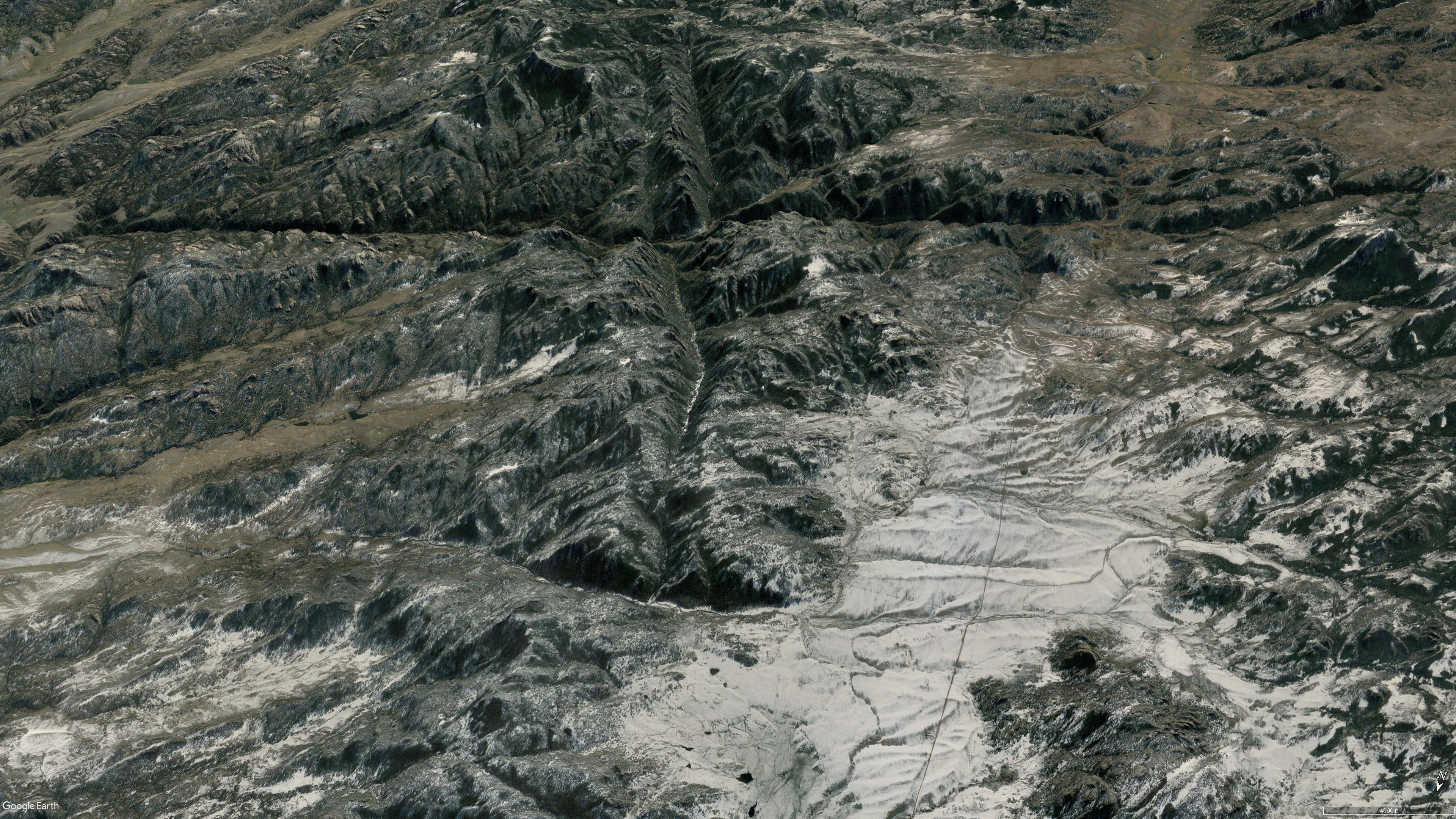
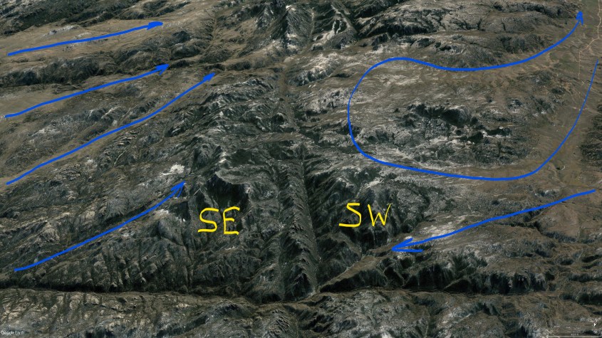
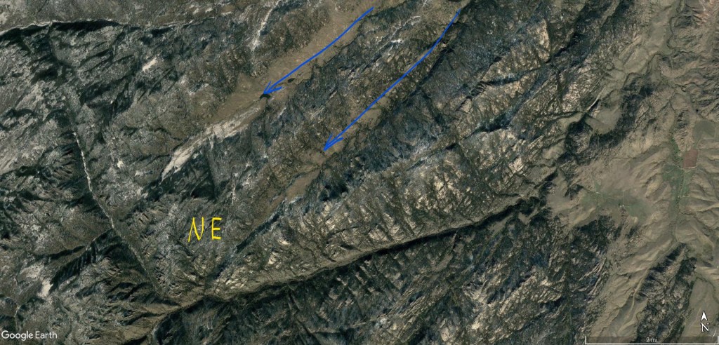
Wind cut channels are sometimes narrow, straight and deep like the capacitive winds in figure 11, and sometimes they snake, divide and join following induction currents, cutting broad valleys with funnel shaped inflows, as shown in Figures 12 through 14. The (a) image is annotated with wind patterns and the (b) image is without markings for comparison.
Winds in the NE quadrant flowed parallel to the SE quadrant winds, and both cut perpendicular to magnetic field lines, but the NE winds shoot inside the loop of magnetic field lines to the apex, whereas the SE winds cut across the loop sideways.
In the NW quadrant, winds followed magnetic field lines, making a sharp bend at the crux of the “X” and staying inside the quadrant, but lifting as they made the turn.
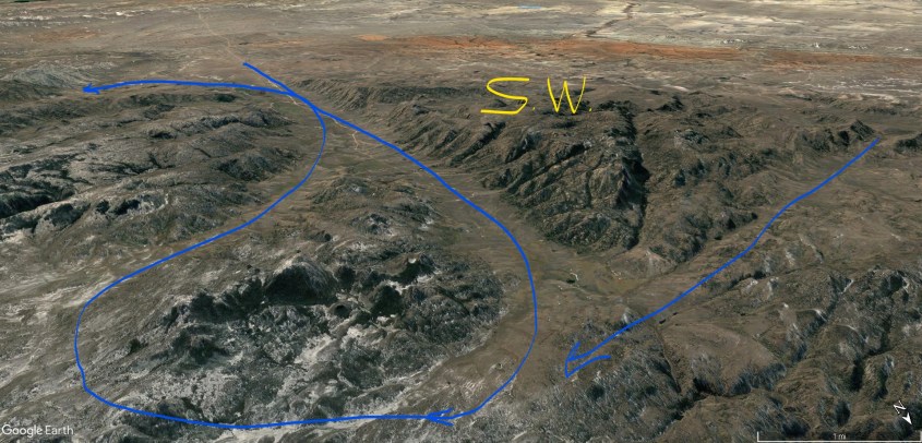
The SW quadrant has a split personality. In one half winds flow straight at the crux of the “X” in direct opposition to wind from the NE quadrant. These winds met in a central updraft that lifted them vertical. In the other half of the quadrant, winds circulate, making an “S” shaped pattern that begins parallel to, and then crosses magnetic field lines perpendicularly.
Figure 12aFigure 12b.
Figure 13a
Figure 13b
Figure 14a
Figure 14b
The reason for winds to flow either parallel to, or perpendicular to magnetic field lines is induction. Both moving magnetic fields and electric fields induce current. Reactive current is called capacitive when it follows electric fields. It is called inductive when it follows magnetic fields. Magnetic fields are perpendicular to electric fields in certain conditions. Since these mountains formed from circuits 180 degrees out-of-phase, things tend to line-up.
The Laramie circuit produced induction currents following both electric and magnetic fields. Winds in the NE quadrant were due to capacitive reactance, following the electric field. The NW quadrant winds were due to inductive reactance, aligned with magnetic field lines. The SW and SE quadrant winds were combinations of capacitive and inductive currents, but expressed in different geometries.
Reactive currents express either inductive, or capacitive behavior, or a mix in different parts of the circuit. Therefore it’s not surprising the southern quadrants have blended currents. What is surprising is how clear the pattern is etched, in spite of all the chaos and violence of this event. On display are electromagnetic forces that stirred the earth, like we would stir iron filings with a magnet.
Further away from the discharge, the southern quadrants mixed into a large tornado with two satellite whirlwinds that lifted wind in this quadrant into the mesocyclone storm (Figure 15). This tornado region sits just south of the “X” which marks the center of the mesocyclone’s central updraft. This position corresponds well with the formation of “wall clouds” that spawn tornadoes in typical thunderstorms.
Figure 15. Both southern quadrants display tornado footprints (violet) and shock waves (green). Blue are ground winds.
The Whirlwinds
Shock waves reverberated absolutely everywhere, creating nearly vertical oriented tetrahedrons layered like fish scales. Shock waves from winds sucking into the maelstrom left triangular wave-forms where separation bubbles formed beneath screaming jet-streams. They display direction of winds that confirms the wind paths described.
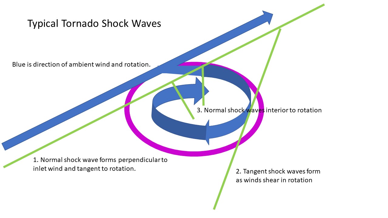
Where wind exceeds supersonic speed and is forced to change direction, shock waves form. They are like folds in the fabric of the wind, which is stiffened into laminar jet streams segregated by extreme pressure differentials.
Tornadoes draw ground winds from all directions, but in a supersonic tornado, there is an inlet zone where the majority of wind enters the rotation. They are drawn from ambient jet stream winds that the tornado forms tangent to. Figure 16 shows winds entering the whirlwind change direction from linear to rotation, forming a large shock wave tangent to the rotation, and parallel to the jet stream (note 1). This inflow shock wave is a distinct feature of tornado “footprints” if the winds involved were supersonic.
If the winds also rotated at supersonic speed, additional shock waves form tangent to the rotation at points of shear between the rotating winds and ambient winds (note 2).
Finally, tornadoes may form shock waves due to shearing interior to the rotation. where they curl inside the inlet zone (note 3).
Figure 16. Supersonic Tornado Shock Waves
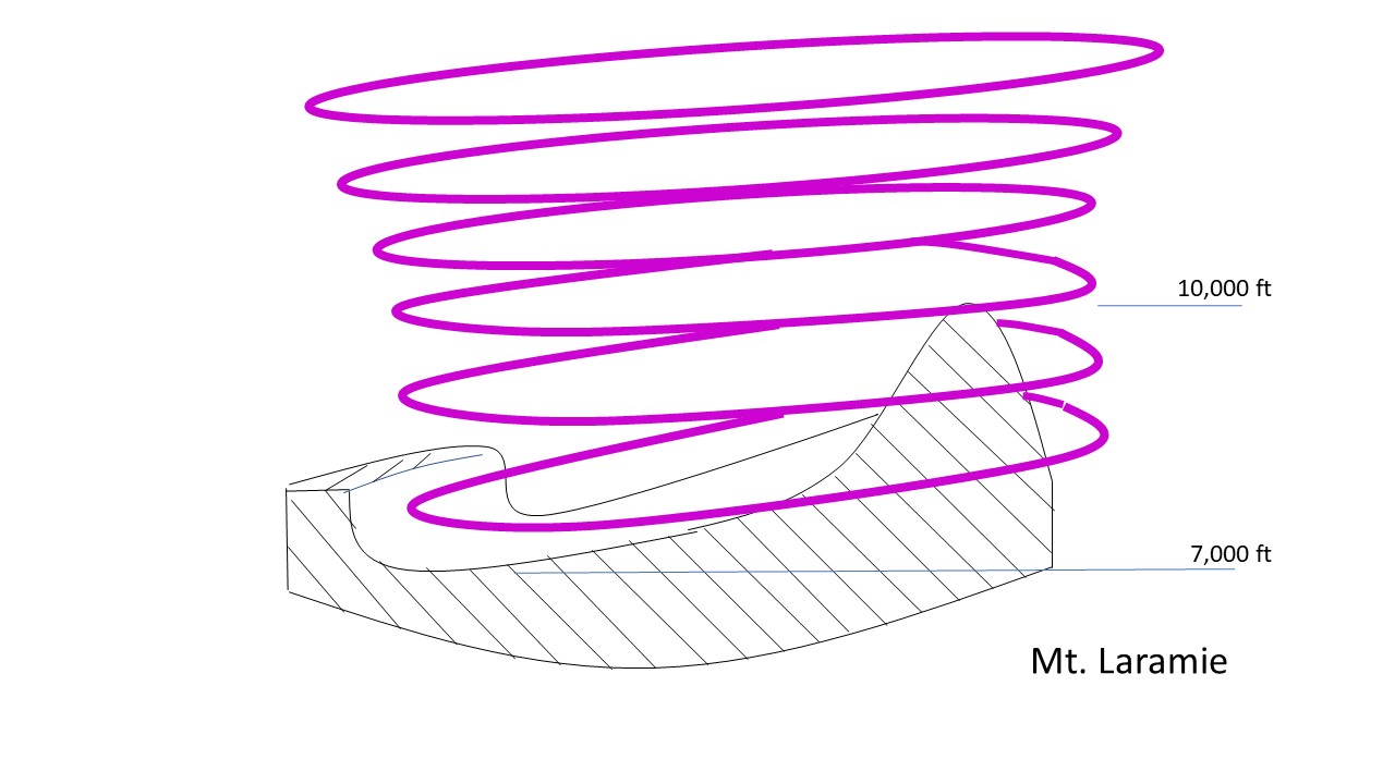
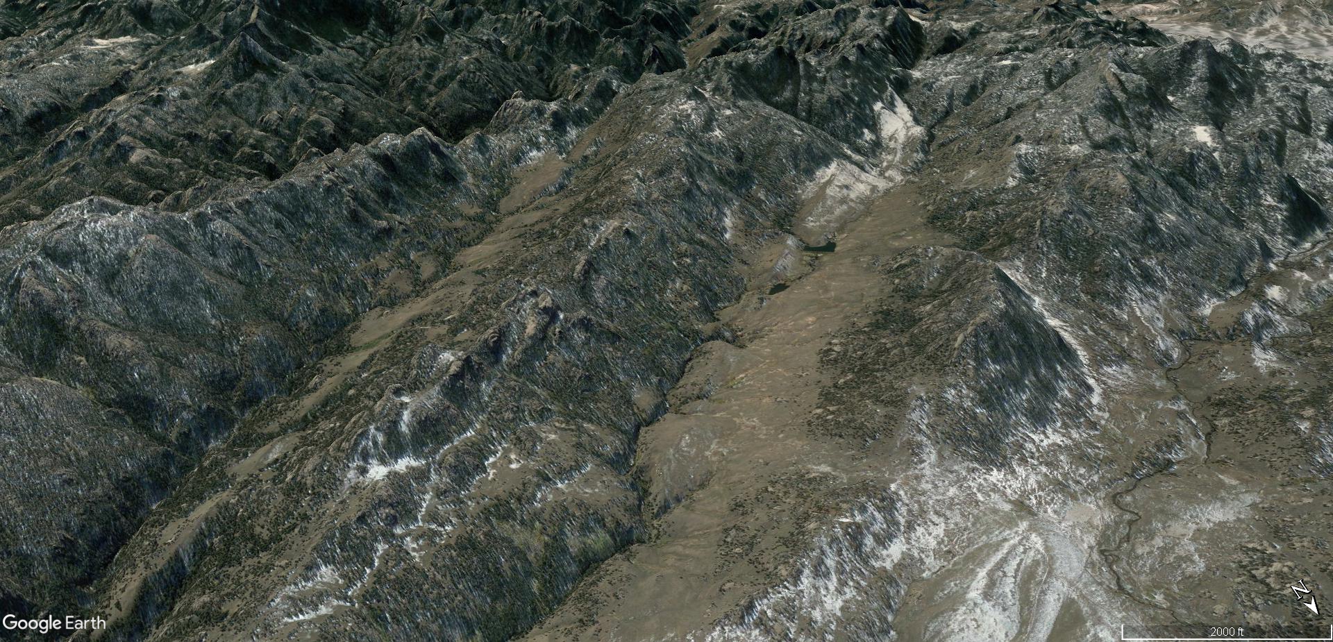
The largest tornado in Figure 15 lies in the SE quadrant and produced Laramie Peak. It’s the highest point in the range at 10,260 ft, and sits next to a gouged-out valley that dips to 6,700 ft elevation. Both the valley and the peak are within the tornado’s rotation. Tornadoes form a cambered debris “bowl” where the winds scrape the ground. The debris is lifted away where the force of inlet winds carve at the land, and then are deposited on the opposite side of the rotation as the winds lift (Figure 17). Mt. Laramie is one such deposit.
Figure 17. Tornado mountain building.
Shock waves are evident where supersonic winds change direction. Examples in Figure 18a are tetrahedrons formed in the NE quadrant, where winds following the electric field lifted to create separation bubbles. They form tetrahedrons in linear rows conventionally known as monoclines, but they are, in fact, supersonic “sand dunes”. This is especially evident if you examine the breaks and inflections caused by constructive and destructive interference patterns.
Figure 18a shows tetrahedrons formed by jet stream winds rising to the mesocyclone in Area 1. A new set of tetrahedral dunes formed in Area 2, which deflected winds and starved Area 3, leaving a triangular interference zone that pinched out formation of tetrahedrons from the shock wave of Area 1. The gap between Areas 1 and 2 turned the wind and formed a tornado (Area 4) in it’s eddy.
Figure 18b shows these same features from another angle and how eddy currents form behind tetrahedrons in a low pressure zone beneath the rising winds. These are, in effect, destructive interference troughs behind the constructive peak of the wave pattern as winds undulated across the ground.
Figure 18a. Shock waves are green; wind direction, blue; destructive interference, orange; and tornado, violet.Figure 18b. Shock waves green; wind direction, blue; wind eddies and tornado in violet.
Domain of the Heart
Stepping back to look at the entire heart-shaped circuit domain in Figure 19; blue lines trace the ground level jet stream winds, violet swirls indicate where tornadoes made definitive features on the ground, red “x”s are discharge patterns, and the green areas are where the thunderstorms down-drafted to the rear and rear flank of the storm (also Figure 20). The two lakes are where the circuits connected to ground deep in the Earth, leaving a distinct “V” shaped land form between them forming the base of the “heart”.
The top of the heart is an accumulation of positively charged matter swept there by winds in-flowing to meso-cyclone updrafts, and the bottom of the heart is a negatively charged basin swept clear by down-drafting winds. These are the anodic and cathodic sides of the domain, neatly separating the top and bottom of the heart. There are several other symmetries and heart analogies hidden there.
Figure 19. Laramie Mountains wind flow pattern. Blue lines are ground wind paths, Violet swirls are tornadoes, Green outlines storm downdrafts. Two other “X” shaped discharges are shown to the SE of central discharge.Figure 20. This basin is the center of down-burst winds from the meso-cyclone. Note the massive erosion and deep, wind cut canyons.
This would have been a horrible place. The discharges blasted negative ions and free electrons away in arc blasts, while drawing positive ions inward. The velocities, temperatures and densities of the winds differed, their dielectric properties differed, their charge densities differed; and they segregated, with the positive inflow hugging the ground, accumulating dust that adhered to the statically charged land. The drag of the winds covered the land with blankets of dust, layered like fish scales, hardened by sonic pressure and electric currents that snapped and crackled everywhere.
The clouds roiled in whirling updrafts overhead. A squall-line of heavy thunderstorms formed in mirror image to the chaos on the ground, spitting lightning in carpet bomb fashion that would have made the clouds glow. Rain fell in torrents of mud and rock. Supersonic winds scoured the ground, in-flowing to biblical whirlwinds, and sonic shock waves reverberated in electrified sheets of plasma current; the entire atmosphere surrounding the storm patterned in the shock-diamond herringbone of flashing, ionized shock waves.
Lightning discharge blossomed like acne, leaving pinnacles, dikes, craters and domes in regions of high tension. Winds stirred around these discharges, disturbing the ambient winds into transient cyclones that left hardened dunes as monuments. And the winds reached supersonic speeds patterned by shock waves that embossed the land with triangular and polygonal wave-forms.
At the time they were made, with all the violent turbulence, heat and electric currents, the mountains likely resembled not so much hard granite, but puddles of hot jam, squished into form by wind and mashed by an electric fork.
Figure 21. Laramie Mountains.
Conclusions
This whole mountain range is direct and unequivocal evidence of electric formation. Conventional means of uplift, faulting and erosion requiring several eons of disconnected events could not, by any reasonably statistical probability produce phase diagrams 15 miles across the face of the earth with induced current paths shaped by magnetic field lines.
The features of these mountains are coherent only when recognized as the result of electrical circuits in the Earth. Each ridge line and canyon, every hill and dale, can be tied to a sequence of events that occurred at one particular phase in Earth’s evolution involving extreme electrical stress on the planet.
Conventional science can’t explain why any two of these features coexist, let alone demonstrate their disjointed theories empirically, or model them with any real plausibility on computers. But you can make discharge patterns like this with some wire and an AC power source. Or, as I have done, bring two out-of-phase plasma balls into contact.
I simply powered one plasma ball with AC current and one with DC, so it produced and in-phase/out-of-phase sequence as the AC side alternated. Between the two balls, the sparks joined and spread with each pulse, like hands clasping, then spreading fingers to push away as energy expended in reactive discharges, perpendicular to the in-phase current flow, just like the “X” patterns in the mountains.
The plasma interaction between the plasma balls didn’t occur at the glass barrier of the globes, as you might expect. It occurred inside the DC ball with the weaker voltage, pushed there by the higher voltage AC ball. Unfortunately, the experiment fried my plasma balls before I could film it. I don’t have the kind of high speed equipment needed to properly photograph it anyway. This image in Figure 21 however, does capture the effect, although I don’t know the circuitry of this set-up.
Figure 22. Tesla coil discharge (white filaments) makes connection with an electrode. Reactive power currents (violet flames) spread in a cone around the discharge.
Figure 21 shows a Tesla coil discharging to an electrode. White filaments of current direct connect to the electrode, while violet plasma flames of reactive power shoot outward in a cone around the discharge. The angle of the cone isn’t 90 degrees, but that is an artifact of this particular circuit and its phase angle.
The Laramie circuit resulted in a discharge along a dipolar alignment between circuit domains, with a capacitive reaction aimed clockwise 90 degrees from the dipolar alignment, and an inductive reaction 90 degrees counter-clockwise, forming a cross, because the domains were exactly 180 degrees out-of-phase.
So, you see the world is a more understandable place than you have been led to believe. To understand it we need to recognize the Earth contains holographic imagery of it’s past charge distributions. The information is there to learn vastly more than we know today about its creation. To get the info, we just need to ask the right questions.
Science, as it’s taught and practiced, does not ask the right questions. If anyone dares, they are silenced.
If you are unaware of how science deceives us, consider what belief in science means today. Undetectable matter, unaccountable energies, multiple dimensions, space-time-gravity, multiple universes and a Big Bang from absolutely nothing. It’s all a bunch of crap, and we can know this by looking – these things aren’t there and they don’t even make sense. Where are the extra dimensions?
Think of the confusion that results. The Earth hasn’t warmed in fifty years; but it will fry us in ten. Don’t use paper, it kills the trees – use plastic, it’s recyclable; don’t use plastic, it kills the fish – use paper, it’s renewable. Stop eating meat, or anything with a face; and kill the cows because they fart too much. Stop factory farms that feed millions because the chemicals harm us; organic farm so there is much less food at much higher prices that poor people can’t afford. Coffee is good for you; coffee is bad for you. Don’t sip energy from the Earth with tiny straws, it damages the environment; replace hydrocarbons with solar panels that require re-wiring the grid and giant open pit mines to extract silver, copper and rare earth minerals. Mask yourself, a virus is loose; wait, there are too many people on the planet.
Science, as it’s taught and practiced, produces the dumbest people because dogmas are reinforced by years of school and politics in lieu of critical thinking. Critical thinking requires more than following the mistakes of pompous academics who think they are gods. Understanding Nature isn’t something taught, it’s an awareness gained by knowing oneself, because we are part of Nature. Consciousness is Universal – the Alpha and Omega of all information – to reach it you must look inside your conscience. For all beings, that is our true connection to the Cosmos.