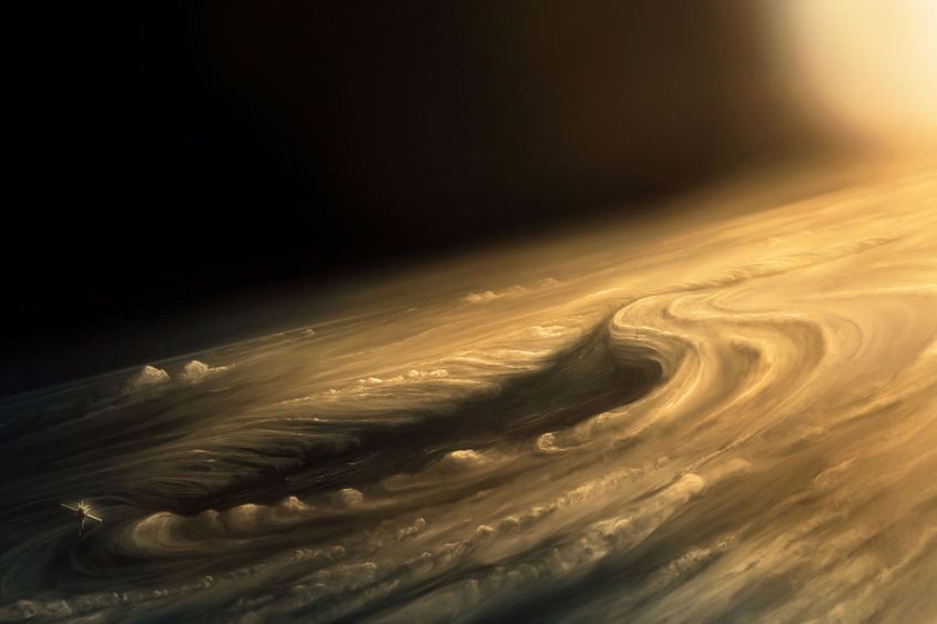
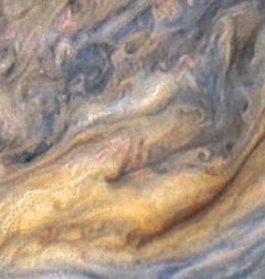
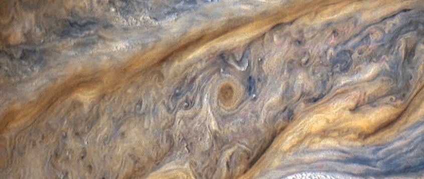
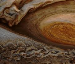
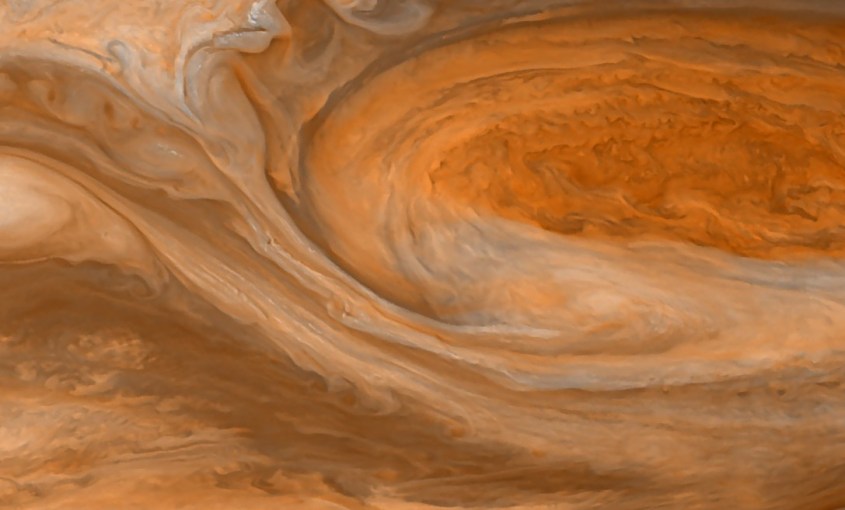
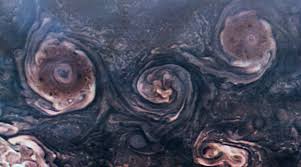
Month: April 2020

Thunderblog: Eye of the Storm – Part 6

The Great Red Spot

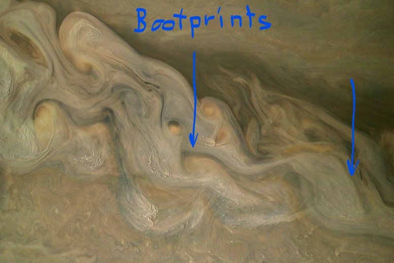
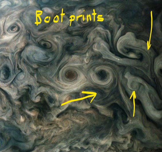
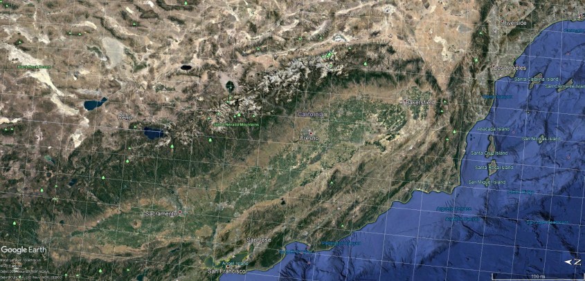
In Part five of this series we looked at “boot print” craters and found there are cyclones raging on Jupiter right now that can explain them. Shock wave patterns in the crater rims provided confirming evidence. We also looked at California’s mountain and valley structures and correlated those with a storm on Jupiter that displays in great detail the very same features. The examples we’ve looked at point to one significant observation: that fractal forms associated with the processes of charge diffusion can be found in both geology and weather.

Why geology and weather should match really isn’t hard to understand. Capacitance between Earth and sky are responsible for that, forcing charge to diffuse through each layer in mirror image. And that should suffice for an answer if our atmosphere were considered a plasma; charged particles responding to Earth’s spherical capacitance would make sense. But Earth’s atmosphere isn’t considered a plasma. Neither is Jupiter’s for that matter. Where are all the charge carriers?

The answer isn’t in particle physics. It’s in the molecule of water. Water is the charge carrier – the electric wires of the circuit. Water is bi-polar, and so adopts polarity in an electric field. This produces something called “bound current”. Unlike a current of free electrons and ions, a bound current is carried by a bulk material that can be polarized or magnetized. An example is a ferro-magnetic fluid that takes structural form in response to magnetic fields. Water is an example of bound current due to polarization of the water molecule.

Water also changes phase: from vapor to droplet to ice crystal, all in the course of a weather cycle, which changes it’s electrical properties. And it’s self ionizing, readily shedding electrons to generate plasma.

DSC02073

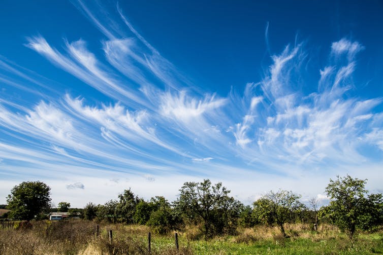
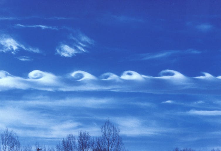
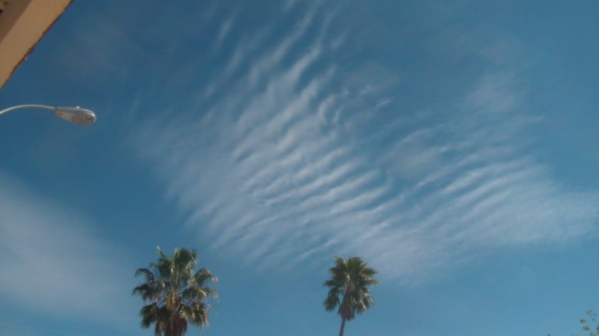
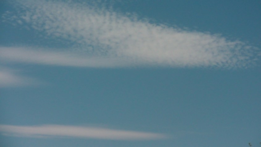
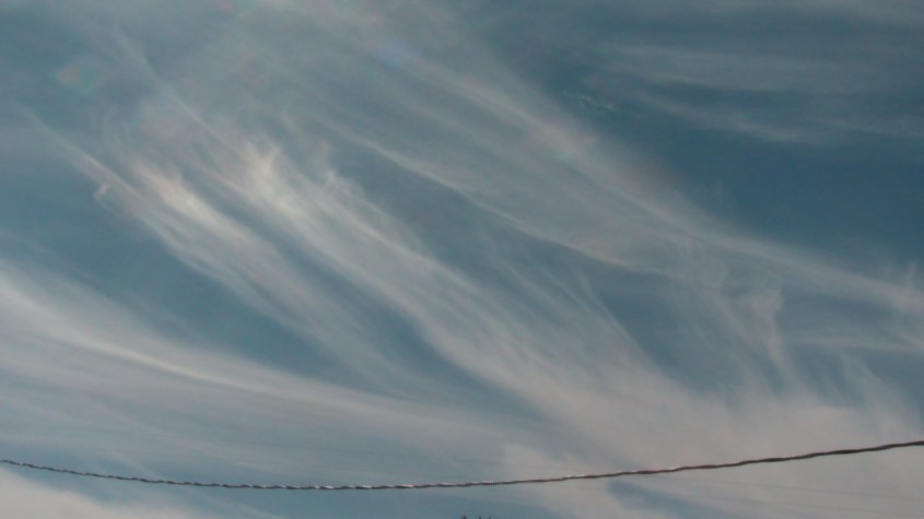
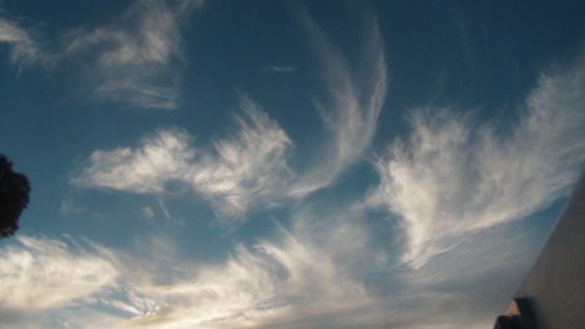
A cold plasma is only partly ionized. A few free electrons and ions floating about. But magnetic fields are created with any moving charge and magnetic fields influence their motion. And water follows, because it polarizes and acts like a big fat charged particle, making clouds into conduits of current generating a stronger magnetic field. Star-like filaments and concentric rings form in thin cirrus of the upper atmosphere. Condensate filaments make turns and shoot tendrils at 90 degrees, crossing other filament paths and interfering in herringbone patterns. These are drift currents, responding to the pull of far-field potential within that layer of strata.

file-20180320-80634-1l34xxcfile-20180320-80634-70c377SAM_0154SAM_0150SAM_0125SAM_0101

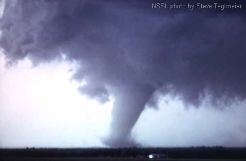
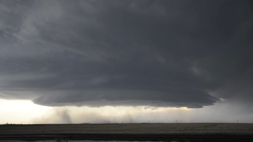
Closer to the ground, fat water clouds form cellular structures, often in tetrahedron shapes, which amplifies waters polarity to a macro-scale. Watch puffy cumulus gather for a storm, ultimately knotting into a torus around up-welling winds to birth a meso-cyclone, and you are seeing a fractal, electromagnetic structure of Nature at work.

SS1

Airborne dust, pollen, aerosols and dander cloud the air close to the ground and react between surface and sky to form a charged sheath, polar opposite to the water clouds in the sky. Higher up, where ice forms, wispy cirrus change polarity again. The result is multiple layers of charged cold plasma between the ionosphere and Earth’s surface.

The sky is electric, but consensus science doesn’t seem to recognize that. They will say there is no evidence of charge densities high enough for plasma. That distances are too large to create double layers and develop capacitance. But they don’t recognize water’s role, and frankly, they aren’t looking. They are looking for answers to their preconceived notions about carbon’s minor role in all this, and don’t even ask the right questions.

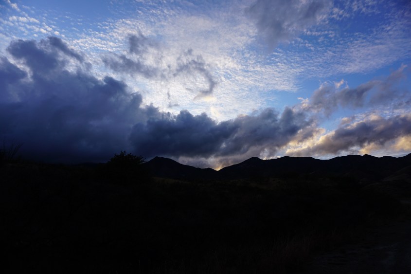
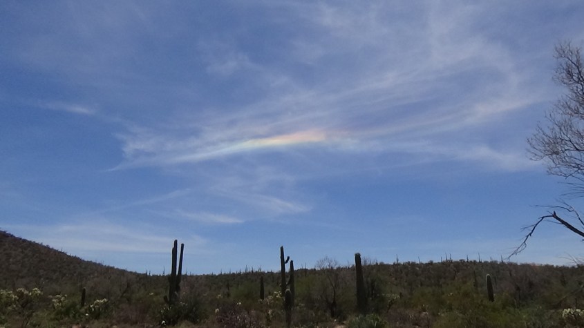
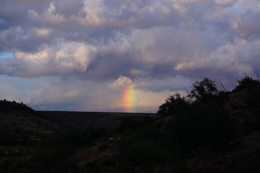
Just look at the clouds and what you see is an electric-field writ large across the sky:

DSC00423imagestorTC_CebileDSC02070

It really couldn’t be more obvious. Just ignore the scientists and use your own noggin. It’s better if you’re not institutionally taught to ask the wrong questions.

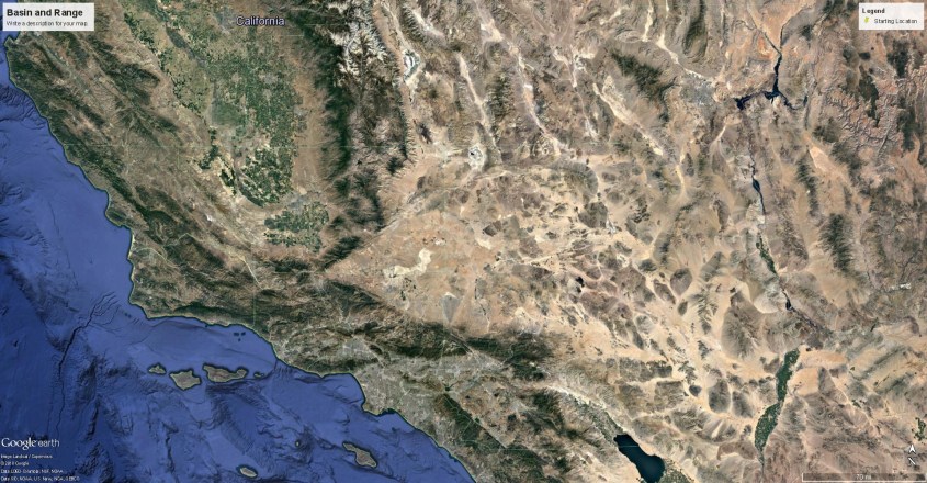
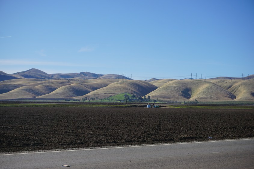
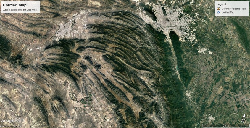
Then take a look at Google Earth, and compare to NASA’s images of Jupiter. You will see all the patterns of Jupiter’s storm clouds reflected in Earth’s geology.

Mountain ranges, and desert dunes carry the shape of the winds that formed them. Rising columns, violent down-bursts, precipitation, whirlwinds and lightning brushed the land like a painter and left indelible brush stokes.

pia21973 (3)_LIcurl2curl3curl4

The similarity of shapes and weather comes from internal circuitry of the planets. This means that Jupiter and Earth are very similar in that regard. Repeating forms at different scales is one proof of a fractal process.

Fractals emerge naturally in chemistry, fluid dynamics and biology, but the process that defines them all – the common denominator – is the process of charge diffusion in an electromagnetic field. It manifests not only at the particle scale, but the atomic, molecular and cellular scale, and produces fractal forms at the macro-scale because they are made coherent with electro-magnetic fields.

The Eye of the Storm

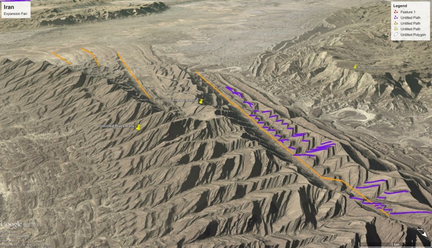
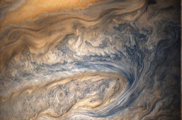
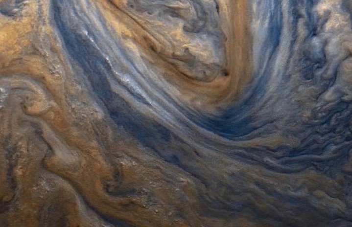
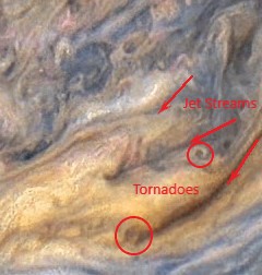
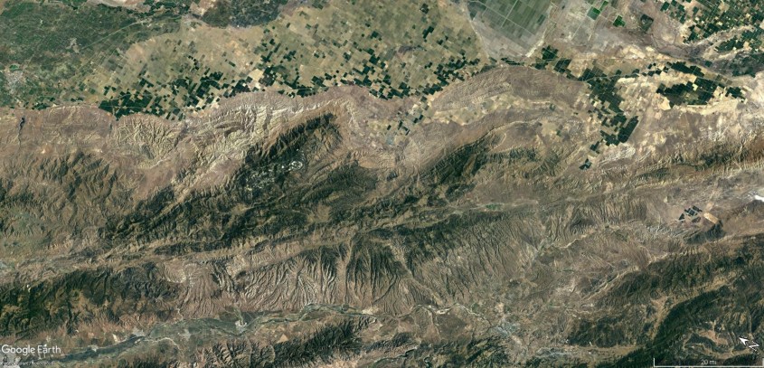
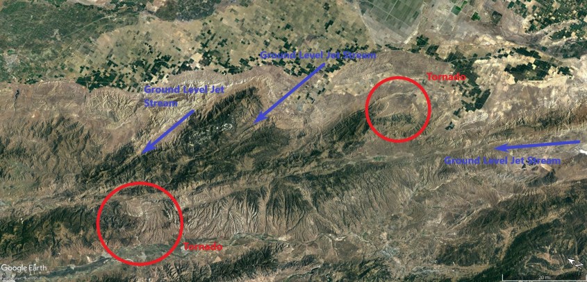
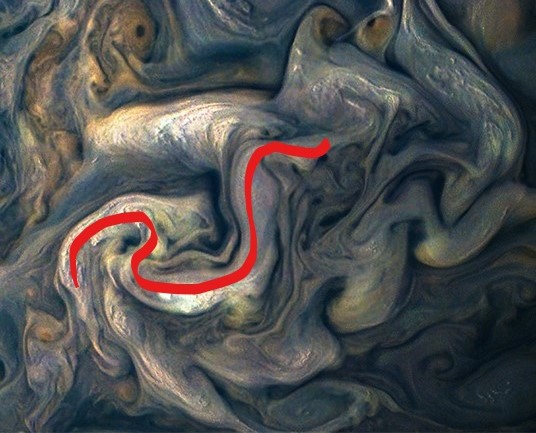
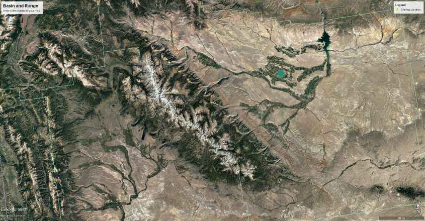
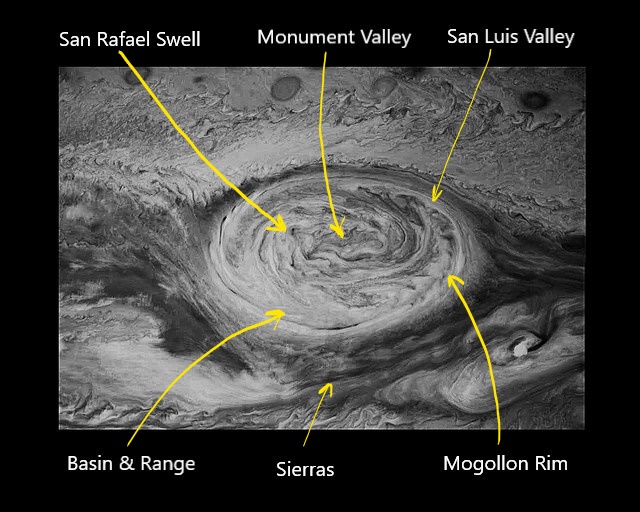
Now let’s raise the voltage a bit and see what happens. A correlation between the Colorado Plateau and the Great Red Spot (GRS) has similarities of such complexity and detail, it seems absolutely surreal. Inflow to the GRS appears in two sinuous lanes of rolling winds that correlate with the mountain ranges in the Pacific Northwest.

Inflownorth

jupiter-red_00319181 (2)

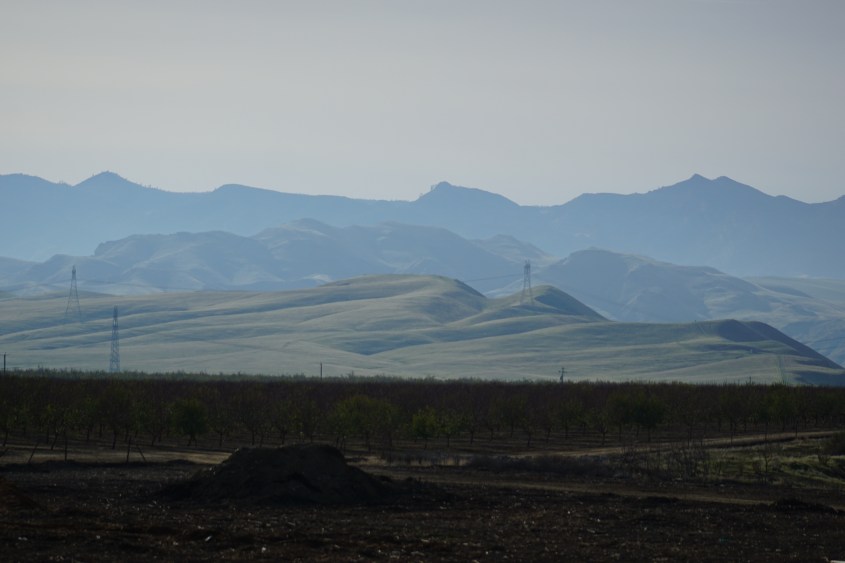
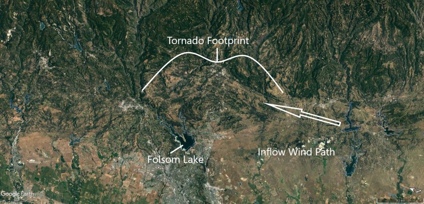
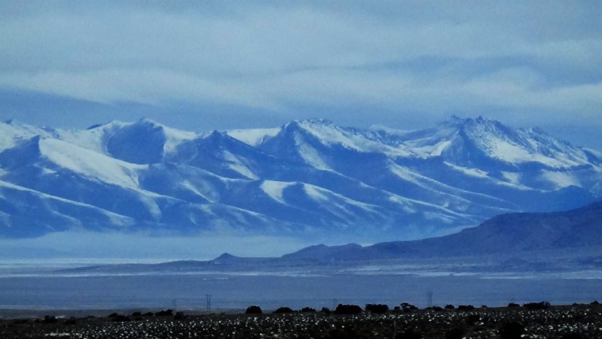
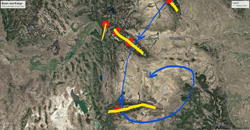
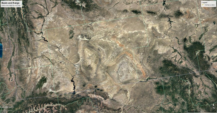
The Great Basin Vortex

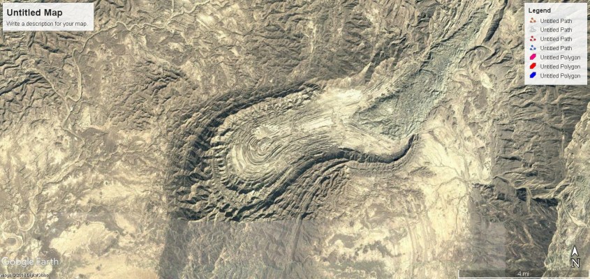
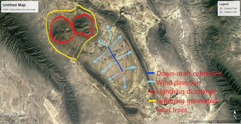
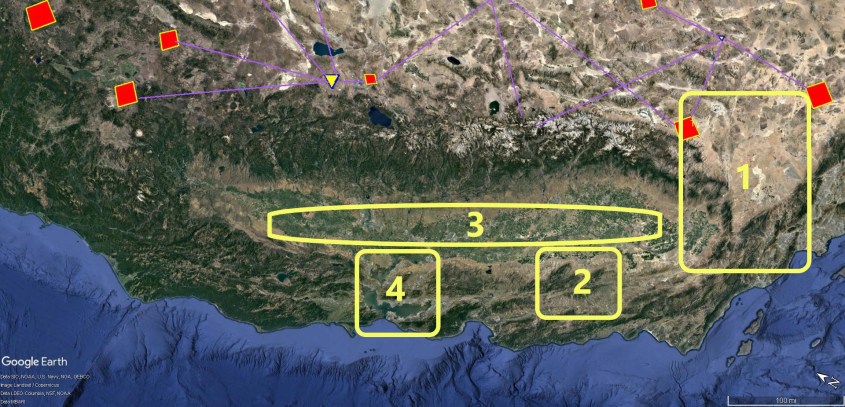
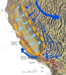
These snaking flows of wind feed a giant thunderhead that occupies the lower third (in the image shown) of the GRS, where white anvil clouds obscure what’s below. Such a meso-cyclone careened over the Great Basin, extending it’s entire rotating wall-cloud clear to the ground. The Great Basin was formed by rippling waves of dust laden winds spun beneath a 100 mile-wide funnel, lashed by torrents of rain.

jupiter-red_00319181 (3)

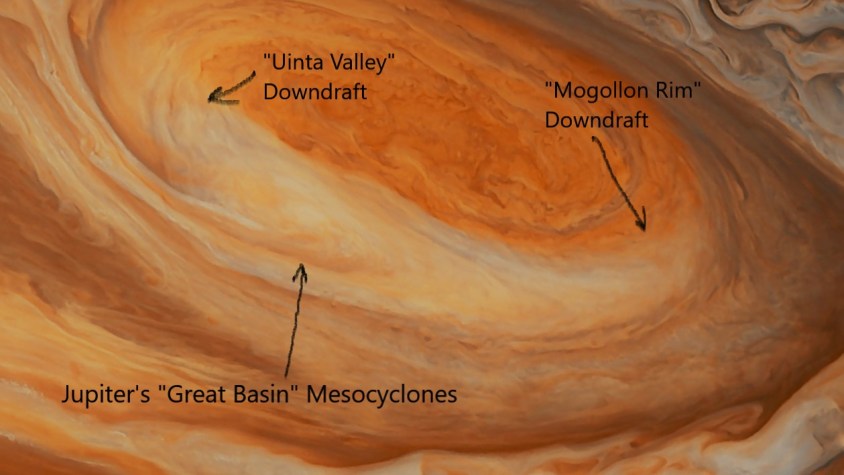
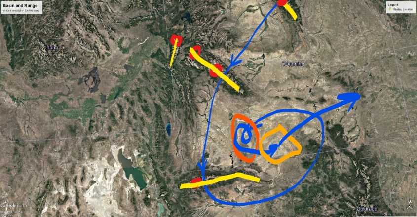
The parallel rows of basin and range mountains that march like rippling dunes across Nevada were laid transverse to the wind. In the annotated image, wind-fronts are denoted by the dark blue lines. There is an “S” shaped range at the inflection point where the in-flow winds bent to the rotating updraft.

WM2_LI (2)
Inflow, rotation, rain curtain and down-drafts portray the exact footprint of a thunderstorm.

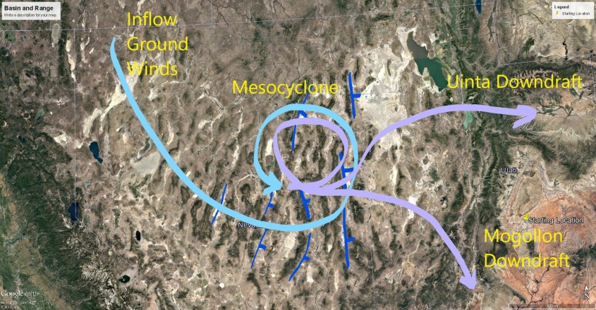
The blue and violet lines denote the wind direction, exiting right (east) at high altitude over Provo, Utah where it made no mark on the land – until it water-fell on the other side of the shear zone that formed the Wasatch Range, spilling a violent downdraft into the Uinta Basin.

Another, larger flanking downdraft flows south over the Wasatch shear zone, and spills down to form the Mogollon Rim, the southern extension of the Colorado Plateau arcing south-east from, roughly, the Kiabab rim of the Grand Canyon to the Gila River in New Mexico. The wind formed rim is intermixed with volcanoes.

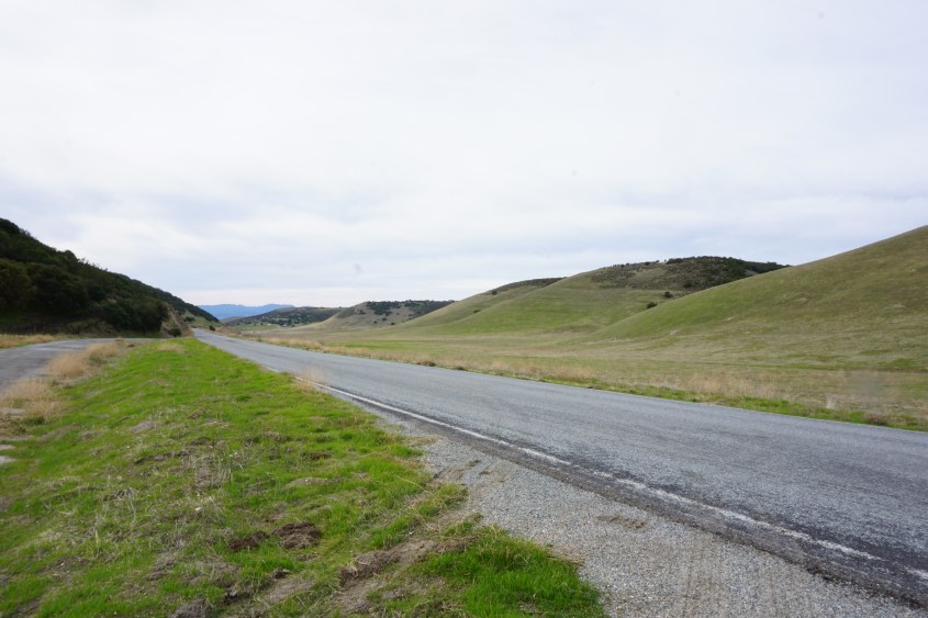
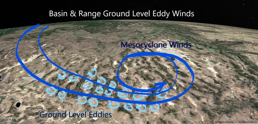
Curiously, Nevada’s mountains display wind-formed tetrahedrons in the opposite direction than expected, given the counter-clockwise rotation of the GRS. I drove through Nevada (twice) to confirm what Google Earth showed, because this was a case where land forms disagreed with my expectation. The best explanation for this, given everything in context, is that ground level eddy winds rolled beneath the meso-cyclone rotation like roller-bearings under a spindle.

Eddy winds22

This was a wet, rotating meso-cyclone, carrying considerable moisture which precipitated out and evaporated forming salt basins behind ranges, and culminating in a rain curtain over what is now the Great Salt Lake and Bonneville Salt Flats.

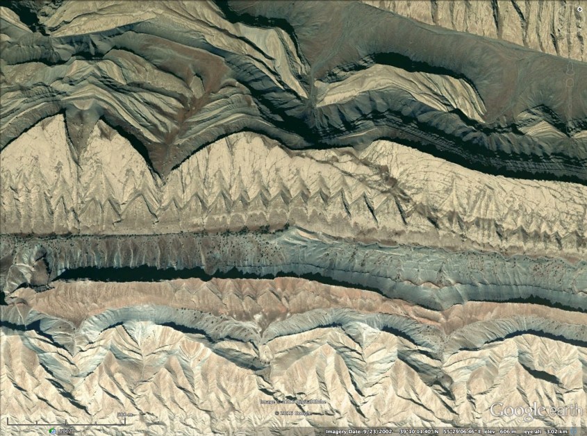
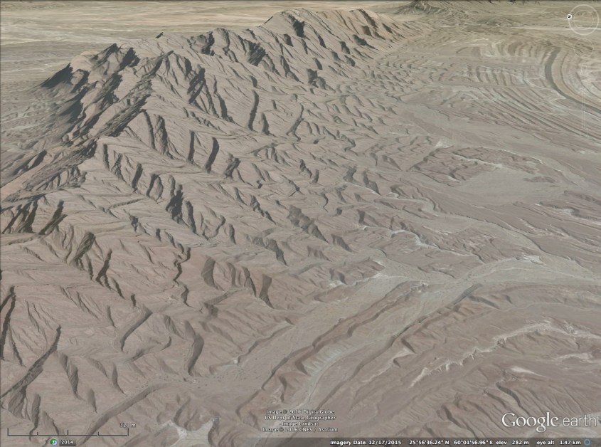
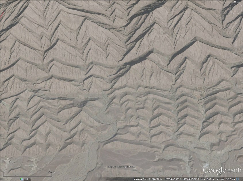
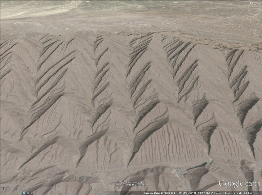
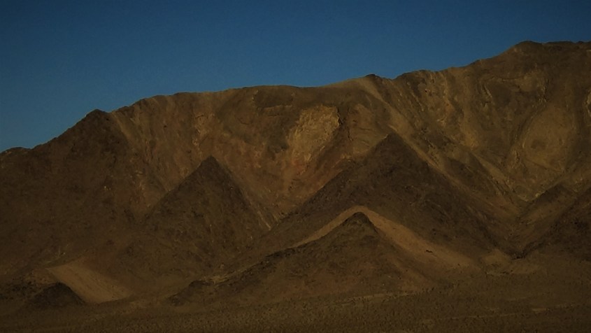
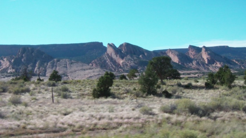
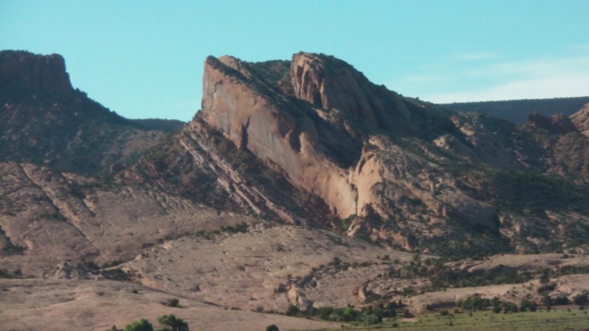
The long, linear mountain ranges of the Great Basin are in many cases windswept dirt. Hard rock, which indicates heat and recombination of ionic matter is absent, or minimal in many cases which indicates low density lightning in this region. The triangular faces of shock wave reflections earmark wind direction. Often, no triangular shock features are present, indicating subsonic flow, so many hills take a recognizable sand-dune shape.
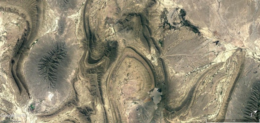
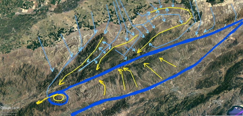
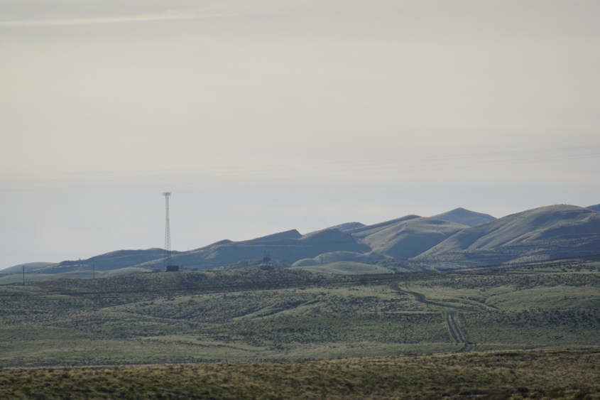
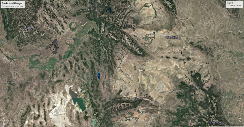
DSC01170DSC01189 (2)DSC01122DSC01209DSC01103 (3)DSC01784DSC017982

The Wyoming Vortex

Where the thunderstorm down-drafted to the northeast, it landed in the Uinta Valley and joined the ground winds of another rotation. Actually, it’s two primary rotations that suck wind from the north to form enormous pressure ridges perpendicular to the wind direction: the Wind River and Uinta Mountains.

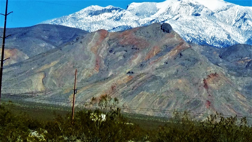
The mountain ranges formed as lightning arced to ground and charge diffused across the land in channeled currents, which formed dikes. Dikes are walls of rock formed from the country rock fused together, and often display troughs alongside where material sucked to the current.

WMinflow3
Wind River Range displays shock-wave tetrahedrons on its northern flank.
WMinflow1_LI (2)
Tetahedrons make clear the direction of the wind

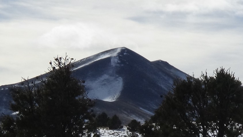
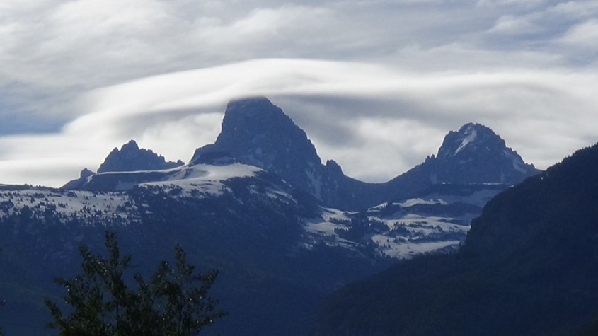
An example is the Teton’s, where Grand Teton itself is a lightning generated fulgurite surrounded by smaller fulgurites blanketed with wind driven dunes. The Teton fulgurite extended a dike to the south which collected dust against it, which drew more lightning to it, creating a mountain lobe.

DSC00532
Grand Teton shrouded in lenticular cloud.
DSC00511
Dikes formed by channeled charge diffusing away from fulgurites provides anchor for wind blown dunes to form.

Wind piled material against dikes to build a mountain lobe, and leave one flank patterned with the sonic shock of the wind. Winds deflecting horizontal to vertical left ruler straight ridge lines of tetrahedrons where shock reflections patterned diamond shaped regions of expansion and compression.

WMinflow3_LI
Wind River lobe with shock-front and wind direction.

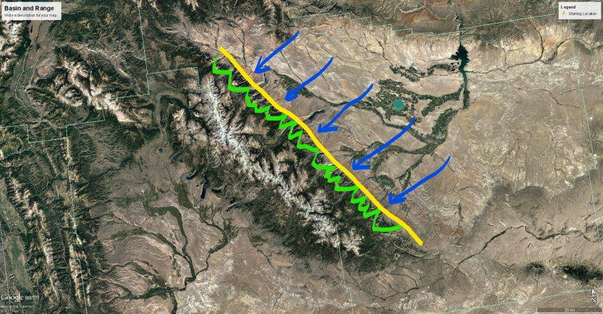
The wind was pulled by twin whirlwinds created by a grounded current loop. It’s footprint is a dome and crater pair. Dome and crater pairs are created by what I call a coronal loop, because electrically it’s the same as a prominence on the Sun. It’s a ring current coupled to the land, and wind sucks up one side in a meso-cyclone that leaves a dome, walled by inward pointing shock-wave tetrahedrons. The wind loops from the thunderhead anvil to feed the center of a down-drafting cyclone, the footprint of which is a crater with outward pointing tetrahedrons.

images009
Two thunderstorms feed a cyclone (center) due to grounded ring currents. These updraft/downdraft sets form dome and crater sets and pairs on Earth.

This pair is squished into almost polygonal shapes because it’s pressed between larger rotations. The Wyoming Vortex is the smallest of three primary vortexes of the larger multi-vortex storm in the GRS. It isn’t apparent in Jupiter’s clouds, but I suspect it’s there under the anvils.
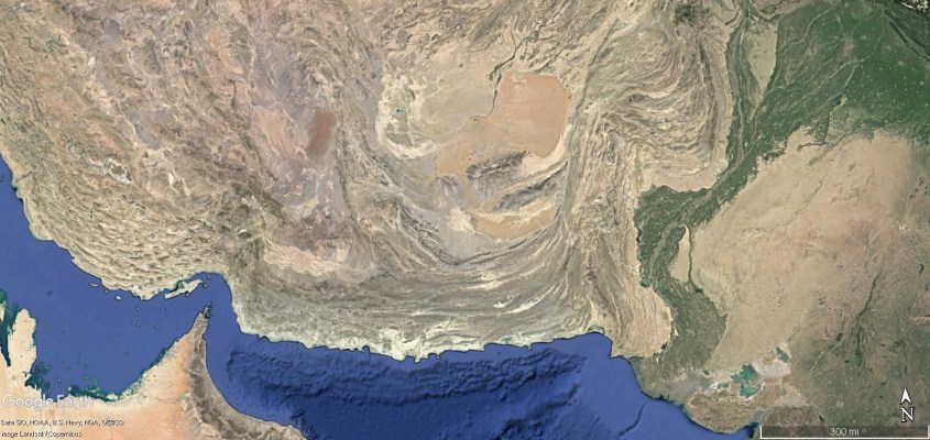
WMinflow5

WMinflow1_LI (3)
The jet-stream wraps over and under itself in three dimensions like rope in a knot, forming a dome on the land, and then a crater. It is a dome and crater pair created by a tight coronal loop.

WMinflow1

Kinky Mexico

From the south, hot dry winds scorched across Mexico and the American southwest with counter-flowing winds. Along the turbulent shear zone between, kinks appear in the Sierra Madre Oriental, where north flowing jet streams mixed with a south flowing stream that formed the Sierra Occidental and the alto-Plano in between.

The kinks in Mexico’s cordilleras match remarkably well the kinks of turbulence where inflow and outflow winds mix adjacent to the GRS. That’s probably an understatement. There are details here to fill a book, but take a close look on Google Earth at these kinks to see some amazing wind and shock wave features.

mexipep1Mexkink3

Mexkink4
Features of the Mexican Kinks

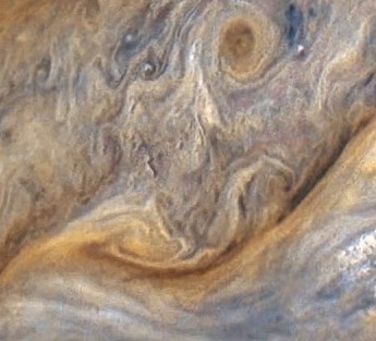
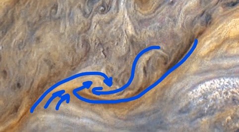
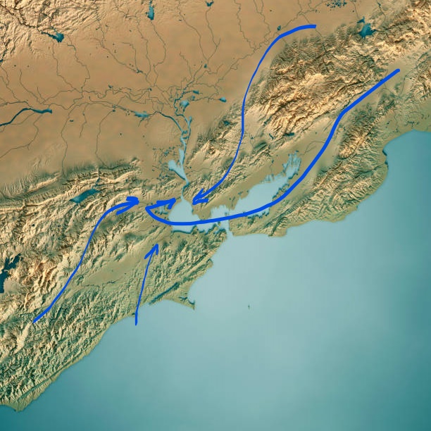
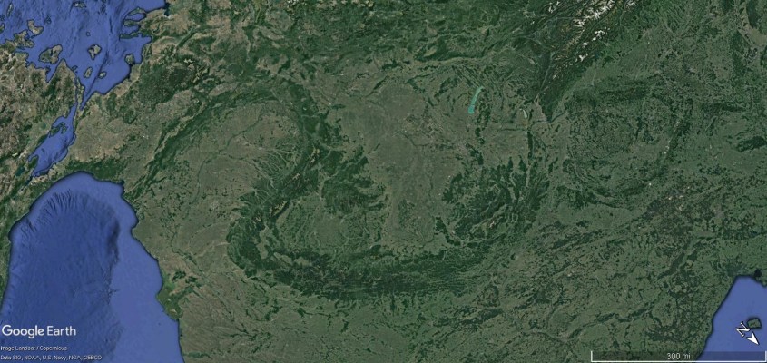
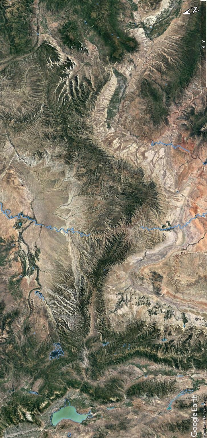
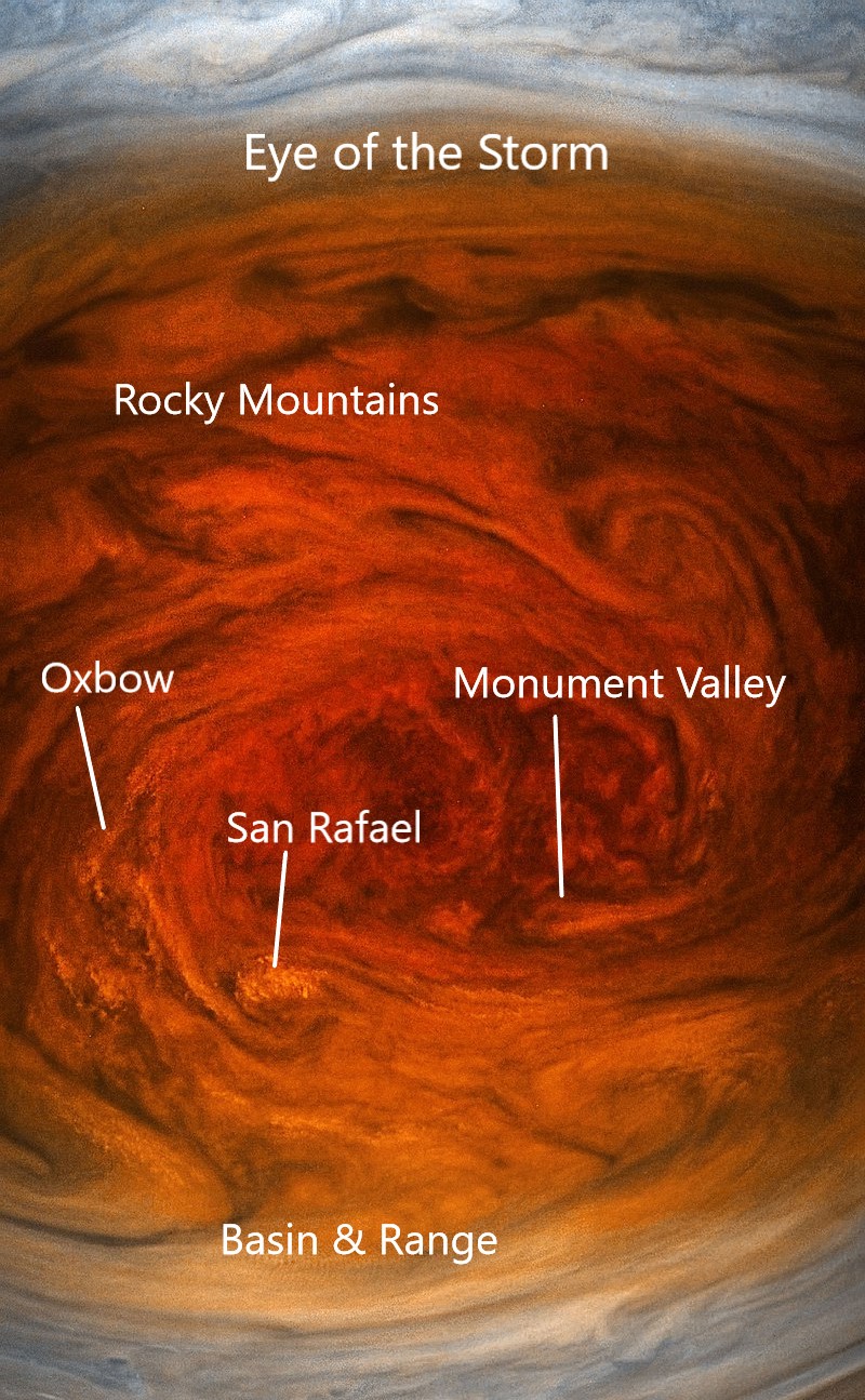
Colorado Plateau and the Eye of the Storm

We looked in an earlier episode at the overall morphology of winds in the very eye of the GRS and the Colorado Plateau. Let’s take an even closer look.

GRS1_LI

The ‘eye’ is a multiple vortex cyclone, which displays a complex system of coronal loops that twist the wind into a crocheted doily pattern.

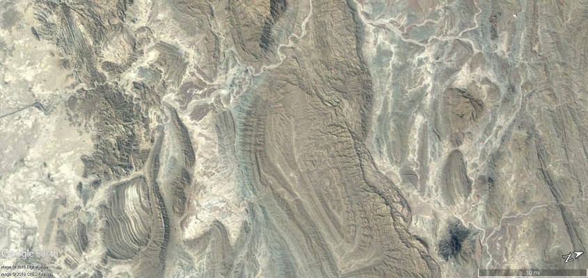
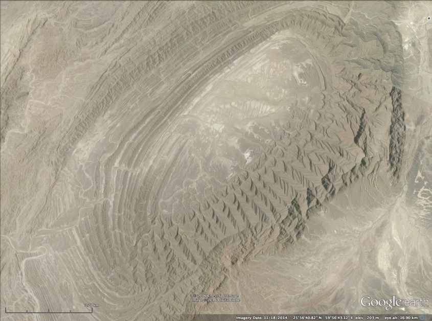
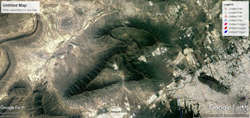
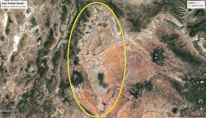
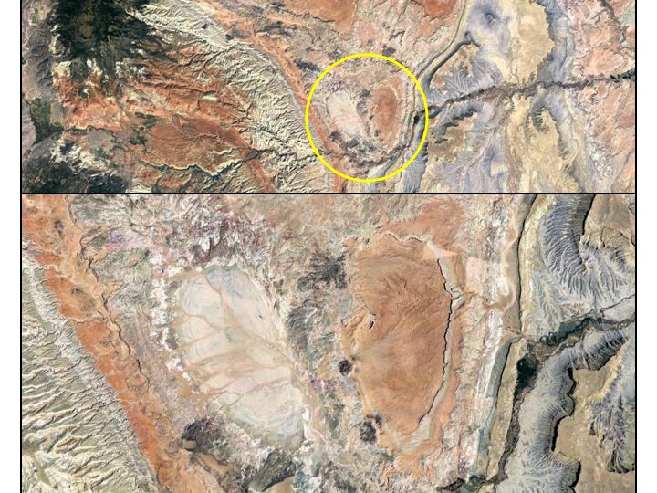
There are several paired updraft domes and downdraft craters centered on the Colorado Plateau and Rocky Mountains. The most distinctive is the San Rafael Swell in central Utah.

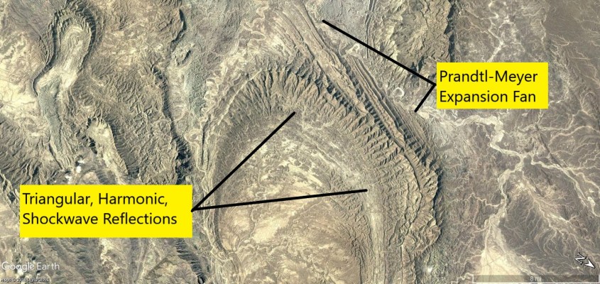
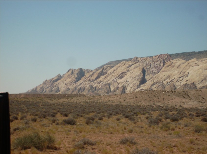
The Swell is ringed by the explosively charged, dense region of recombination and magnetic pinch known as the San Rafael Reef, where rows of dragon’s teeth – tetrahedral monoliths of hard, fused sandstone – provide evidence of a shock wave at the boundary of the updraft.

dsci0474

The Reef is the rim of an updraft dome formed beneath an intense coronal-loop that raged electrical havoc on the land at the sharp end of the storm. The dome behind is shaped like one lens of an eyeglass, the other lens an inverse copy made by the downdraft of the same loop.

UDSR1
San Rafael Dome is electrically etched, or sputtered by an intense electric field in the eye of the storm above it. Purple indicates wind-front of the San Rafael Reef. Green outlines shock front of updraft exhibited by triangular buttresses. Red indicates major lightning.
CL1
Google Earth – San Rafael Swell is northern lobe. Downdraft crater is mirror image outlined by a tributary of the Green River – all a consequence of electrical circuits.
NA15
The San Rafael Reef discontinues at the “bridge” between the ‘spectacle’s’ lenses. Capitol Reef forms a continuation of the sinuous wind-front on the backside of the downdraft crater.

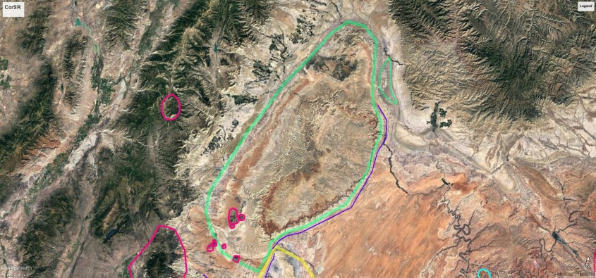
The downdraft crater has a central peak of lightning struck mountains where material drew up in winds generated by the return stroke of the lightning. The rim of the crater forms Capitol Reef, where more monolithic tetrahedrons display wind direction and Mach angles pointing outwards.

SAM_0379
Capitol Reef is the shock front of down-burst winds surrounding a crater.
SAM_0380
Monstrous, multi-layered tetrahedral buttresses splay outward from the crater to form Capitol Reef.

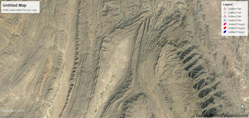
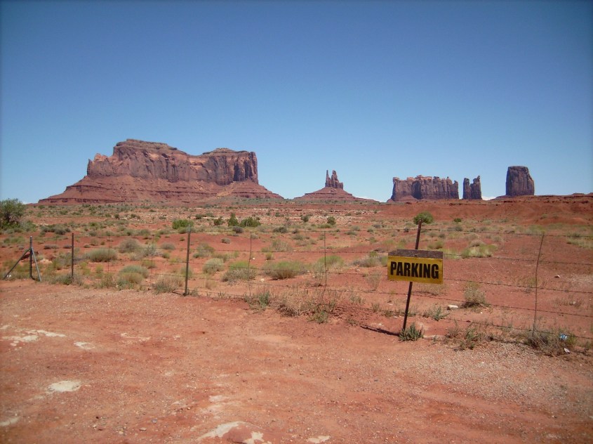
Another example of an updraft dome is Monument Valley, Arizona. It’s shark’s teeth rim is formed by inflow winds, expressed in the triangular sandstone layers of Comb Ridge.

kayenta12
Comb Ridge
kayenta2
Complex super-sonic wave-forms – Comb Ridge, Arizona
ssresonance
Complex super-sonic wave-forms – laboratory.

The interior of the dome is the sputtered remnants of lightning diffused mesas and pinnacles, preferentially left behind as the landscape around lifted away in the most intense electric-field in the eye of the storm.

DSCI0098
Monument Valley

The downdraft leg of the Monument Valley ring current lies in the bend of the San Juan River, as it passes through the Four Corners region.

Monument1

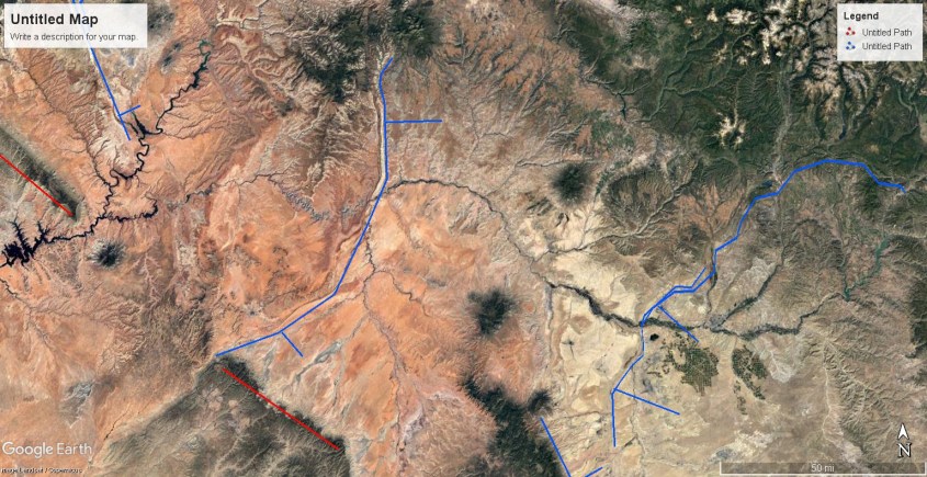
Annotated to distinguish the features, the same eye-glass shape is evident where this coronal loop connects with Earth, but the shape is skewed to the ambient counter-clockwise rotation of the entire storm system. The downdraft lies at 90 degrees to the updraft because of fractal symmetry – something we’ll discuss more – and the ambient rotation of the eye. Once again, the crater has a central peak of lightning fused mountains, but it’s crater rim has largely been swept away and its face flattened by the press of rotating winds. This is “ground zero” for the eye of the storm.

Monument1_LI (2)
The frame is broken, but the lenses are intact. Downdraft at 90 degrees to updraft. In the broader perspective, one can see the circular rotation imprint continues along Black Mesa and defines the eye of the storm.

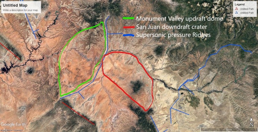
Note, the San Juan River arcs around the downdraft after it passes through the center of the updraft, just as the tributary of the Green River wrapped around the Capitol Reef downdraft crater and then shot through the heart of the San Rafael Dome. These are the fractal forms of surface conductive discharges, or “arc blast”, and the rivers are part of it (which will be discussed in future articles).

Fractal Elements

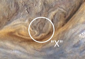
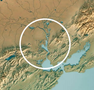
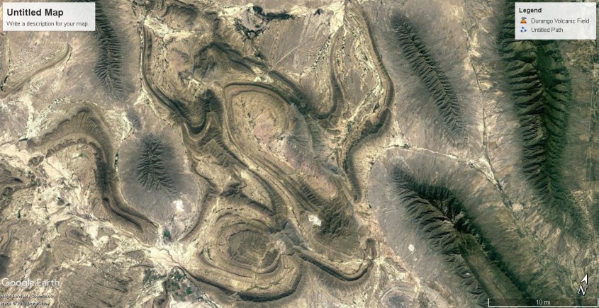
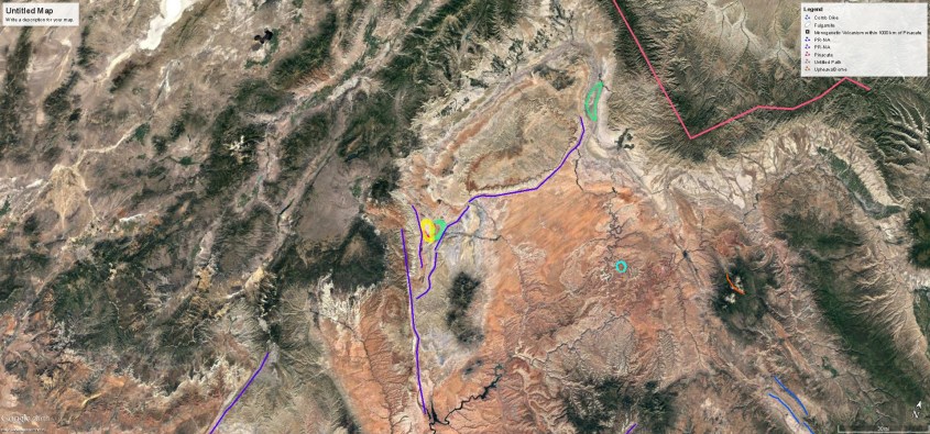
A shear zone separates the Wyoming vortex from the eye rotation over the Plateau. At this shear zone, like others, mountains formed beneath welling updrafts. In this case, nestled against the powerful updrafts of the San Rafael Swell and surrounding cyclones, it formed in the shape of an oxbow.

oxbow2oxbow (2)

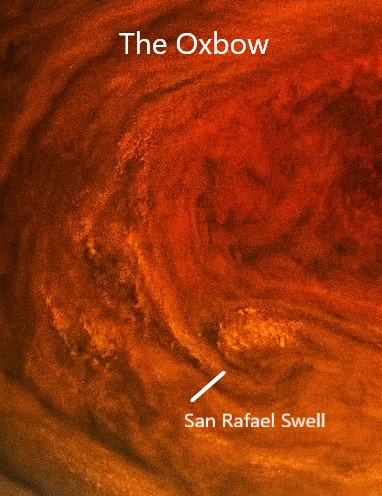
Here we see one of the wonders of fractal forms. The “oxbow” on Jupiter is a distorted image of the “oxbow” on Earth, with the bows curving in opposite arcs. Seems odd, but Nature is kind of dyslexic. Fractals display rotational and translational symmetries, meaning a shape can be in any of several orientations – rotated at 90, or 180 degrees, or flipped about one axis in mirror image, or translated back-assward. When this happens it doesn’t change the overall structure it’s a part of, and the energy balance remains the same.

Harmonic repetitions also appear. The most striking example lies smack between the updraft dome and downdraft crater of the San Rafael coronal storm loop.

Slide28
This butterfly pattern is from an intense loop of current that created an updraft dome (right lobe) and a downdraft crater (left lobe) complete with stratified triangular buttresses to point wind direction; inward and up, or downward and out; respectively. Each lobe is about seven miles across, whereas the San Rafael Dome is about seventy miles across.

Watch this fractal expression expand in scale. Images are taken along a “z” axis in space from a single point on the ground, at varying altitudes.

20miles_LI330miles_LI (2)1230miles_LI (3)

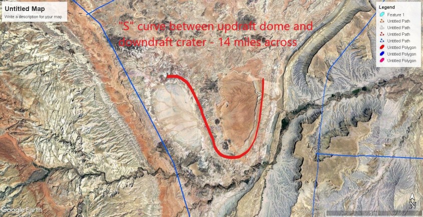
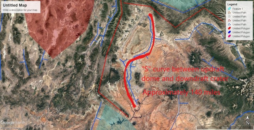
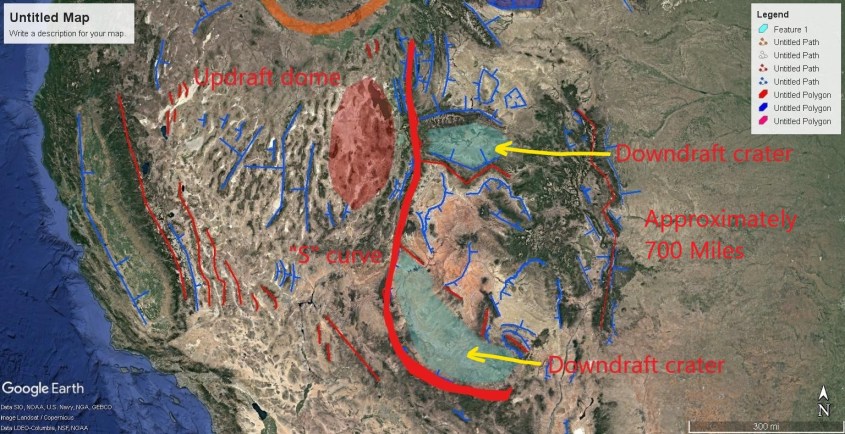
The fractal repeats, but the center point of each fractal expression stays in place. It morphs in form with emergent effects, but the fundamental circuit relationships remain solidly displayed. They are the same weather patterns we have today, but of super-Olympian scale, as told in countless ancient accounts. We need to start listening to the ancients, because they knew things we don’t.

800px-Great_red_spot_juno_20170712 (3)

Eye of the Storm has presented an aerial view of the coupling of Earth’s atmosphere to it’s surface, so far. Next episode, it’s time to switch and talk about the other side of the mirror – the dark side of the mirror. Below Earth’s crust lie dragons and demons.

Thank you.

PLEASE, DON’T FORGET TO TIP.

$5.00

Thunderblog: Eye of the Storm – Part 5

Large Scale Wind Structures

In previous articles we established a link between the winds of Jupiter and land forms on Earth. In primordial times, Earth’s weather was like Jupiter’s, with raging plasma whirlwinds and segregated electric jet streams that attained supersonic speeds. Close examination of mountains and other land forms shows clear evidence of wind-blown deposition that layered the land, supersonic shock waves that shaped mountain flanks, massive lightning discharges that welded rock, and plasma vortexes that blow-torched the land.

Jupiter’s winds are the result of capacitance between double layers in the atmosphere and the plasma sheath at the planet’s surface. We don’t know what the surface of Jupiter is, but it doesn’t matter – it still forms a plasma sheath – a double layer at the interface between crust and atmosphere. Electric circuits form the winds; by capacitance, inductance and magnetic fields. Surface and atmosphere are coupled by capacitance, and ongoing release of energy from Jupiter’s interior is what stirs the winds.

On Earth, dust particles, aerosols and the water cycle – evaporation, condensation, ice and rain – are the charge carriers, or the “wires” of the circuit. On Jupiter, it also includes ammonia and other species.

Regardless of the difference in chemistry between Earth and Jupiter, charge diffusion in Nature follows patterns. A lightning bolt on Jupiter is like a lightning bolt on Earth. It is a discharge between plasma layers that takes a fractal path as ionized filaments react in feedback with the magnetic field the current produces.

Fractal forms are generated by this feedback loop in any process of charge diffusion. They are not restricted to the Litchenburg pattern of a lightning bolt, but are evident in the helical path of field aligned Berkeland currents, the geometry of electro-magnetic fields, and drift currents reacting to far-field potentials.

So it should be no surprise at all to find the same fractal patterns in Jupiter’s winds as we find on Earth’s landscape, if indeed the landscape was formed by similar winds.

99

Boot Prints

One spade-shaped feature is almost ubiquitous in Jupiter’s turbulence: the ‘boot print’. On Jupiter, the boot print is the down-drafting eye of a cyclone being pinched in the turbulent flow of competing winds. Like a hurricane, it is fed by billowing thunderstorms surrounding a whirlpool, which together forms a piece of a circuit – a ring current between the atmosphere and ground. The shape at the cloud tops is carried to the surface and reflected there, because the structure is a fractal, rotating filament of current reaching the surface.

jupiter-juno-2.png (2)_LIjupiter-juno-3.png (2)_LI

wqod5siuupzkvo4po6ql (8)
Boot Prints!

When Earth’s weather raged like Jupiter’s, Earth was in it’s formative age. The continents were being built, as layer upon layer of dust accumulated on a foundation of volcanic flows. Turbulent cyclones in Earth’s atmosphere produced boot prints identical in form to the boot prints on Jupiter. Boot prints on Earth are literally, the footprints of storms.

iranpep4close1close3iranpep5

Boot prints on Earth are clear evidence of electric formation, because they display exactly what is expected in fine detail. The boot print is the consequence of a down bursting wind – a hot, ionized, super-sonic, dust laden wind aimed at the ground like a blow-torch.

The mountain rim is the pattern of a standing shock wave. The repeating triangular layers on the inner flanks are impressed there by harmonic shock reflections, which channeled the wind at the boundary layer, and trapped dust in the low pressure zone of the triangular wave-forms.

guapo3_LI (2)

Shock waves produce triangular patterns of expansion and compression when a supersonic wind is deflected — like when it hits solid land.

p1l3

003101j.12
Separation Bubble

Just ahead of where a shock wave reflects, a low pressure region forms called the “Separation Bubble”. The separation bubble is in the shape of a tetrahedron, with a triangular face perpendicular to the wind at the same angle as the shock wave reflection – called the Mach angle.

As dust laden, ionized winds pass through the separation bubble, this low pressure region collects dust like a vacuum cleaner, and piles it in triangular layers. Therefore the rims, or mountains surrounding a boot print crater display these triangular layers.

PakistanLayersAsia6expfaniran8Asia 7Astroiranradial3Asian 8

If a down burst wind strikes at an angle, rotates, or its mass flow is biased to one side, it will affect the shape of the crater it forms. Boot prints are often accompanied by a feature called a Prandtl-Meyer expansion fan. It is a series of standing shock waves that form linear rays of compression and rarefaction where the wind strikes and reflects off an object. This pattern implies the boot print is the result of an obliquely striking wind that rotated.

close2

If you have ever watched tornadoes, you probably noticed they are rarely perfectly vertical. They contact the ground at an angle, and the rotating wind is lifted to one side, and grinds against the ground on the opposite side. That is precisely what has happened here to produce a boot print crater with an expansion fan.

union_city_oklahoma_tornado_mature

This single example is proof of my theory. Anyone with a supersonic wind tunnel can produce a Prandtl-Meyer expansion fan, tetrahedron shaped separation bubbles and triangular harmonic reflections – it’s been done countless times. But show a way to produce all of these together in a large scale coherent form by tectonic uplift, seismic vibration, slip faulting, erosion, or any other conventional geophysical means. Can’t be done. It is uniquely the result of supersonic shock. Nature provides rational, obvious proof, without need for computers or numeric models.

The pattern is not vague, like Jesus on a piece of toast. It is confirmed in every detail. The correlation is not only visual similarity, but also causation – vertical high speed winds, electrically charged and shaped by electromagnetic fields. Proof of the winds of Jupiter are in NASA’s data; proof of the ground effects on Earth are under our feet, and in decades of applied science in supersonic shock wave behavior. Proper interpretation of data and some wind tunnel testing would put the issue to bed.

But maybe I can do that with this next example.

California

California’s most prominent feature is the San Joaquin Valley and it’s ring of mountains, including the imposing Sierra Nevada mountain arc and coastal ranges. Inside this bathtub, the floor of the valley is a long, flat plain, which at one time was an ancient sea bed.

california1

It was created by a storm like this on Jupiter. So, let’s look at some amazing details.

nasa-juno-jupiter-september-1-001-2-470x310@2x

In this image, I indicate four specific areas we’ll discuss.

one234

Area 1 – Mojave Desert

This almost perfect triangular plain of high desert is demarcated by the straight line of the Tehachapi mountains to the north, and the straight line of San Gabriel mountains to the south, which also, by the way, aligns with the San Andreas Fault.

WMinfow13

It correlates to the region of low level winds, tinted blue, at the cusp of the oval storm rotation on Jupiter. These winds are sinking winds – that is they are pressing against the ground in a Venturi effect as they speed around the cusp of the storm. The yellow-brown ring of the storm is a rising wind, forming what is essentially a continuous ring of thunderstorms. The sharp triangular demarcation between desert and mountain is the shear zone where shock waves formed between the low level horizontal winds and the rising winds of the rotating storm.

maxresdefault2 (4)WMinfow12

th (62)_LI
Brown denotes high level rotating winds, blue are ground level winds. Red indicates the San Andreas Fault.

As these winds rounded the corner into the Venturi, they accelerated, gouging the deep Owens, Saline, Amorgosa and Death Valleys. Separating these valleys rise eleven thousand foot ridge lines of the Panamint, Darwin and Amorgosa ranges. They formed as sastrugi, parallel to the jet streams in low pressure interference zones between the laminar jet streams.

Lightning in this region was imposing. A plasma intensifies in a shear zone, meaning it  generates ion content due to the shearing and extreme temperature and pressure differentials. Shearing supersonic winds bounce shock waves between them, generating high current density in jet-streams that extended for thousands of miles. Lightning discharge from these plasma streams focused on the piling mountains below with the capacity of a thousand mile long thunderstorm being continually fed new energy.

The current dumped in the strike zone didn’t simply flash a split second, here and there, but arced continuously, diffusing through the land welding granite from dust and sand. That is why the Sierras, in this southern portion of the range, have the most impressive granite structures: Yosemite, Mt. Whitney, it’s neighboring peaks, and the Domes. The granite of the Sierras lies atop sediments, which implies the storm(s), by either wind or tsunami, brought layers of dust long before lightning began to strike.

Area 2 – Coalinga

Coaling Station “A” was it’s original name. Coalinga, as it’s called today, is an oil patch town. The foothills that surround it are oil fields – anticlines of shallow sandstone saturated in heavy oil. Similar anticlines flank the western side of the San Joaquin Valley, from Coalinga to the end of the bath tub at Bakersfield. These anticlines compose some of the largest oilfields in North America.

What created them was like this turbulent region in Jupiter’s clouds. The colorized image from NASA shows a crab-claw cloud structure, with high level clouds in yellow, and low level clouds in blue and black. There are several tornado rotations along the boundaries of opposing flows. There are also deep, dark, linear filaments.

Tornadoes.

maxresdefault2 (2)one22

Now correlate the dark filaments with the deep cut, linear valleys near Coalinga. The dark filaments are ground level jet streams, which are what formed these valleys by preventing dust from depositing. Follow the filament in Jupiter’s cloud and it ends in a tornado. Follow the valleys near Coalinga and they end in hills with spiral features. In other words, the filaments are jet streams hugging the ground, cutting beneath the storm clouds to feed a giant tornado. Fascinating isn’t it?

Abacachu
Jet-streams and tornadoes near Coalinga
DSC03672
Linear jet-stream cut valley near Coalinga
california8_LI
General wind patterns near Coalinga

Blue lines in the wind pattern image represent ground level winds, combing across the San Joaquin Valley, and rising into thunderstorms. Yellow represents the higher level meso-cyclone winds which rained dust and rock. The blue winds approach the thunderstorms orthogonally, then rise in the updraft of the storm. Dark blue lines are the tornadoes and ground hugging jet streams.

A drive through the region shows the mountains are wind blown dunes that rise abruptly from the flat valley floor, and display exactly the wind patterns I describe.

DSC03802DSC03825DSC03722DSC03816DSC03380

It seems chaotic – winds criss-crossing in every direction. But it’s not. The overall wind structure is called a Kelvin-Helmholtz instability. It’s a fractal pattern that happens all the time if there is wind shear.

Area 3 – San Joaquin Valley

Look inside the yellow ring of thunderstorms, and see there are dozens of small vortexes. These are tornadoes, or perhaps water spouts, because the San Joaquin Valley was likely a sea at the time.

maxresdefault2 (6)

Among all the tiny whirlwinds is one giant tornado almost in the center of the storm. This feature correlates well with a circular region of the Sierra foothills at the North end of the San Joaquin Valley. If you have ever driven from Sacramento to Lake Tahoe on State Highway 50, past the town of Folsom where I once lived, you have climbed the Sierra foothills that constitute this feature. A distinct swirl is evident in the hills just above (to the East) of Folsom Lake.

Caliswirl-a

The swirl is fed by ground level winds entering the vortex from the left (South), whereas the top level winds in Jupiter’s cloud tops flow in from below (from the West on the Earth image). This indicates differences in flow patterns between double layers due to the rotational symmetry of fractals. Fractal rotational symmetry is when a fractal shape repeats, but rotated by 90, or 180 degrees. This indicates the wind clocks around ninety degrees at different layers of the storm. The same thing occurs in hurricanes and meso-cyclones on Earth, even today.

Area 4 – San Fransisco Bay

Here, you are literally seeing the drain in the bath tub. Follow the dark filaments in Jupiter’s clouds and they converge in a vortex.

maxresdefault2 (5)

Compare the dark filaments on Jupiter to the long, linear valleys leading to San Francisco Bay, and you see the same pattern. The dark filaments are ground level jet streams that scoured the land, while the light-colored cloud tops are thunderstorm anvils raining charged dust to form the mountains.

maxresdefault2_LI (3)

istockphoto-854988282-612x612_LI

Look close at Jupiter’s clouds near the center of rotation and there is a dark “X” shaped feature. Then compare to the Sacramento Delta and you’ll see, the Delta is the top of the “X”. Again, it’s because the dark filaments are ground scouring winds, which in this case scoured the land to a depth below current sea level.

SacDelta1bayarea (2)

I hope these images provide unambiguous evidence of how the Earth was formed. Any one, or two matching features between the clouds of Jupiter and the Earth’s landscape could be coincidence. But overlay Jupiter’s oval storm on California and all seven features depicted here match in both shape and position, and the wind patterns not only look like, but explain the land features. At least they do if you apply electric circuitry, and ignore consensus science.

There is a host of interesting things to learn by understanding California’s true formation. For instance, a whirlwind formed hill in Kern County is full of ancient shark’s teeth fossils. These sharks date to the middle Miocene, roughly 15 million years ago by consensus chronology. I don’t trust consensus chronology, but it does place a bookmark in the fossil and geologic record. Oil sands in San Joaquin date from the Miocene and earlier, except for one shallow Pliocene sediment. The Miocene epoch that formed Shark Hill was likely the last time such a mountain building storm raged over California. But stratigraphy and the fossil record suggests there were many similar fractal storms in earlier epochs.

sharktooth
Shark tooth fossil from Shark Tooth Hill, Kern County, California

Thank you.

PLEASE, DON’T FORGET TO TIP.

$5.00

Three Days of Darkness

Will the internet go down? Will that obnoxious black rectangle in your pocket go quiet? Is it necessary there be darkness so the light comes on, clearer and brighter than before?

Or will the virus kill you? Or the flu? Or slipping in the shower tomorrow morning? Guess which is most likely.

Will the economy reset? Will trillions in pilfered stash from cartels and corrupt elites pay our debts? And will my crypto-hodle make me rich? (Shit, I hope so.)

I hope we see 10 cent coffee again. Maybe even the wars end, and we can all just be friends.

Certainly, the storm is now upon us. Will Orange God-Emperor save us? Did Moses split the sea?

Passover

Passover marks the release of Jews from slavery in Egypt. Slavery was ended by a series of plagues – the final one being the Passover, when for three days Jews sheltered inside and painted their doors with lamb’s blood. A plague, three days of darkness, and slavery ended.

“Stretch out your hand toward the sky so that darkness will spread over Egypt—darkness that can be felt.” So Moses stretched out his hand toward the sky, and total darkness covered all Egypt for three days. No one could see anyone else or leave his place for three days. — Exodus 10:21–23

And the first born of the Egyptians perished:

“There will be loud wailing throughout Egypt—worse than there has ever been or ever will be again.” — Exodus 11:4–6

Hur-rah … I mean, how sad!
obama-pharaoh

When the Jews celebrate Passover, it’s date is set for the vernal equinox after the spring crop has come fruitful. This year, we know there is corn ready for to be cut. The full moon will mark the equinox on April 7.

It’s been said many times… history repeats itself.

ThanQ.