

Large Scale Ground Features
Telluric currents, or simply ground currents, are electric currents that diffuse through the Earth’s crust, influencing what happens on the surface and in the atmosphere. They control where storms brew, the direction of jet streams and flood waters, even where mountains form.
It’s cause is capacitance, and the resultant effect of charge and magnetic fields in motion: inductance. Where current flows in conductive paths beneath Earth’s crust, the atmosphere ‘mirrors’ the pathways with currents of ionized wind – although, because of electromagnetic influence, it is a ‘fun house’ mirror effect. Just as we’ve traced the effects of winds on the landscape and mapped their turbulent route, we can also map major ground currents.
We can only speculate on the nature of subsurface currents, because we can’t see them, other than to say they are hot and electric. We don’t know the conductor they travel in, but we can say they are “surface conductive”, meaning the currents flow in a particular layer, or regime of layers under the crust.
Current flows in surface conductive layers where ionization occurs most readily. Capacitance induces charge to collect at the boundary between layers of different material, because each material has different properties. Surface tension has to form at the interface of layers, which places higher charge density at the interfaces to form a double layer of capacitance induced, opposing charge, and a voltage drop.
The troposphere is example of such a regime above our heads, where atmosphere ionizes, brewing thunderstorms and cyclones. Ground currents flow under the crust, deep in strata we can only imagine and decipher through sonic echo. But we can also infer their paths from surface expressions.
They express themselves where magnetic fields pierce the crustal layer, creating a path for current to discharge. These are volcanoes. So, briefly let’s look at how volcanoes form as a result of ground currents.

To understand the Electric Earth, one must understand that everything is in constant flux. Nothing in the electrical circuit is static.
Moving current in Nature generates magnetic fields that are dynamic, pulsing and undulating; contracting and expanding in feedback to charge density and momentum in the current that creates it.

The magnetic flux of a moving current rings around the current according to the “right hand rule”. It also filaments, like electric current, forming tubes of magnetic flux.
Eddy current is induced to flow in a helical path along these tubes. Where these filaments penetrate the crust, a channel forms as heat builds from resistance to the induced current, melting and drawing up magma. A blister forms on Earth’s surface where current, heat and trapped gases push through and escape.
Study volcanic cinder cones, and you’ll find they often – not always – display a perceptible counter-clockwise twist to their form which is a result of the upward spiraling current induced along the magnetic line of flux.

So let’s define two types of ground currents:
Primary Ground Currents – primary currents are large snaking veins of subsurface current flowing pole-to-pole, creating what is perceived as plate boundaries. Indeed, they form the continental plate boundaries, mid-ocean ridges and deep rift zones. But it’s not because the plates are broken and rolling over each other in the consensus theory of “subduction”. Ridges and rift zones, volcanic chains and islands are the magnetic signature of the primary subsurface currents, where the crust is broken, softened and hot.

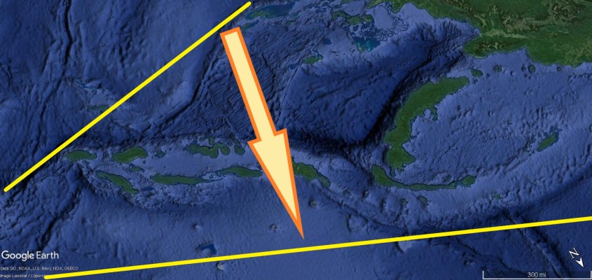
Then there are secondary current filaments that form ring currents that loop away, perpendicular from the primary current. One obvious secondary ring is on display in the deep ocean trenches and island chains in the Caribbean. This image shows the ring current that loops through the Caribbean from the Eastern Pacific Rise portion of the Ring of Fire.


Where the secondary current connects to primary, the juncture is called a “triple junction”. Triple junctions occur at the plate boundaries. For instance, the Rivera Triple Junction is where the Rivera Plate meets the Eastern Pacific Rise (EPR). The Rivera Triple Junction is also where the Caribbean secondary loop connects to the primary. Triple junctions are known hot spots for volcanic and seismic activity, and magnetic anomalies.
The point is that there is correlation between secondary loops and fractures in the crust. Fractures are electro-mechanical signatures of the ground currents, and triple junctions indicate the juncture of secondary loops.
Another reason we can infer this ground current loop is the string of volcanoes along it. From Jamaica to where it hooks south to the coast of Venezuela, volcanic island chains are magnetic expressions of the Caribbean current loop. Islands appear to the inside of the loop, and deep trenches appear to the outside. The “right hand rule” tells us current direction is north in this loop, inducing hot current to well-up left of it’s path, and pulling down the sea-floor to it’s right.

There is also evidence the current moved, snaking south to form the Cuban island chain before locking it’s position in a straight line. Where the current dives beneath Central America to the Rivera Plate in the Pacific, a volcanic lineament shows its path.

Lateral current movements of this type can be found all over the world, making ground current mapping fun. The momentum change in the current produces distinctive arcs of deep depressions, lakes, mountains and volcanic island chains, as the current first bends into sinuous paths before snapping straight. The sinuous curves show the resistance to compression, like a steel spring being squeezed.


The arrows in these images point the apparent direction of the lateral movement. Note there are a few arrows pointing both ways, meaning I’m not sure which way it went.

One of the reasons currents make these lateral moves is because each side of the loop flows in opposite directions, creating dipolar attraction that narrows the loop. Volcanic activity and faulting is greatest at the curvatures in the loop, because it is where charge density and change in momentum is greatest, producing the strongest electric fields.
If we apply this same basic morphology – that triple junctions are connections between primary and secondary currents, that secondary currents raise volcanoes and create depressions, and that lateral current movement occurs where these features are most prevalent, we can use this to infer a secondary current beneath North America.
The Great Attractors
Now let’s examine North America, and the epicenter of the storm over the Colorado Plateau. Thanks to Jupiter, we understand it’s wind patterns, how they correlate to the plateau, and we can now correlate those with the significant volcanic lineaments in North America, adding another layer of information to analyze.

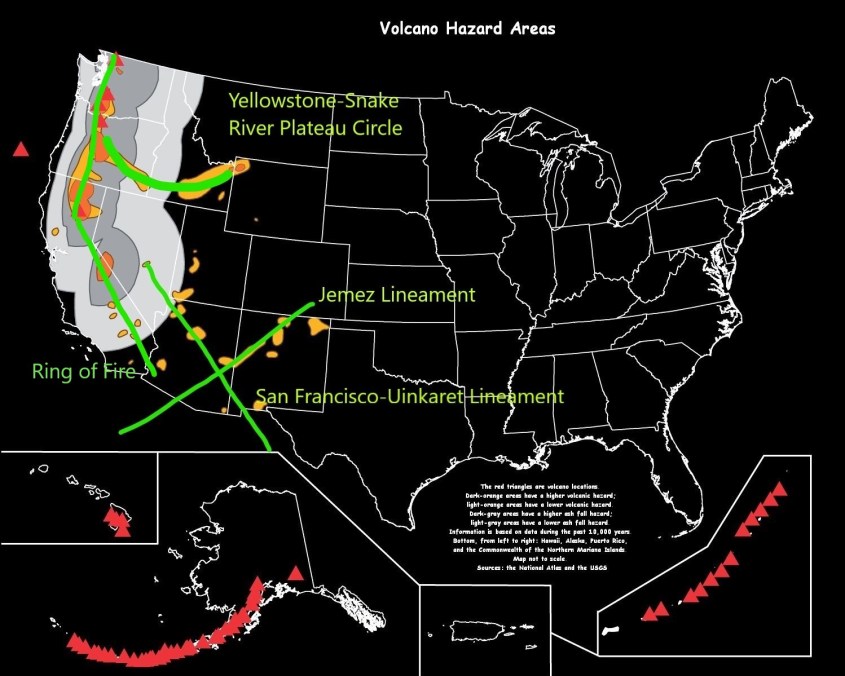
The Ring of Fire is the most obvious path of a primary polar current. Along North America, this portion of the ‘Ring” defines the plate boundary and a lineament of strato-volcanoes from Alaska to Central America.
If you connect the volcanoes like dots, this portion of the Ring of Fire forms two lineaments, or straight line features down the west coast of North America.
The volcanic chains are the expression of induced current rising through the crust, and faulting is from electro-mechanical down force. The volcano lineaments are east of the faulting, implying a south directed current according to the “right hand rule”.
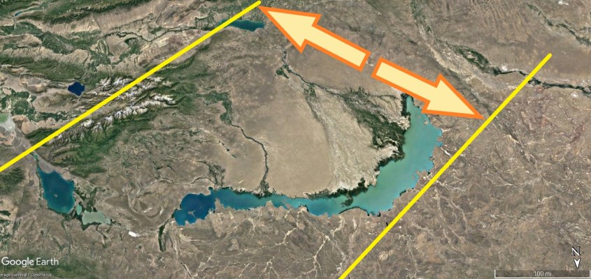
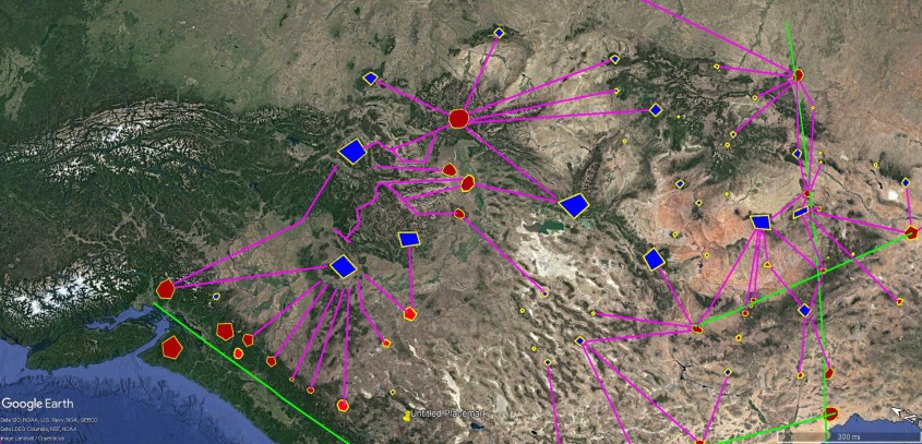
There are three other major lineaments in central North America’s interior. Yellowstone super-volcano is one end of a curving lineament of volcanoes in a trend that forms a part of the Snake River Valley across southern Idaho.

To the south, is a string of volcanic fields called the Jemez Lineament. The Jemez Lineament extends diagonally from the Pinacate Volcanic field in Sonora, Mexico, northeast across Arizona, to the border between Colorado and New Mexico.

It’s bisected by a northwest-to-southeast lineament of volcanoes that include the San Francisco Peaks and the Uinkaret volcanoes on the North Rim of Grand Canyon.

With all of these plotted together on one map, a pattern begins to emerge that implies a secondary current loop beneath North America.
Consider volcanoes an electrode poking through the surface of the crust. Plotted, the Jemez and San Francisco Peak volcanic lineaments produce an almost perpendicular cross pattern, juxtaposed symmetrically across the Colorado Plateau from the volcanoes of the Yellowstone complex, and aligned with the Ring of Fire.

The Jemez lineament aims directly to the Guadalupe micro-plate to the southwest, and to the arc of the Great Lakes to the Northeast
The loop appears to circle the Great Lakes and points back to the Black Hills in South Dakota, which appears to be an inflection point. From there it points to the Juan de Fuca plate in a direct line through Yellowstone.
It has a similar shape and size to the Caribbean current loop, with the base of the loop wider than the tip.
Similar to the Caribbean Loop, there is a significant depression at the tip. In this case the Great Lakes, but they reside on the inside of the loop, whereas ocean trenches are outside the Caribbean Loop.

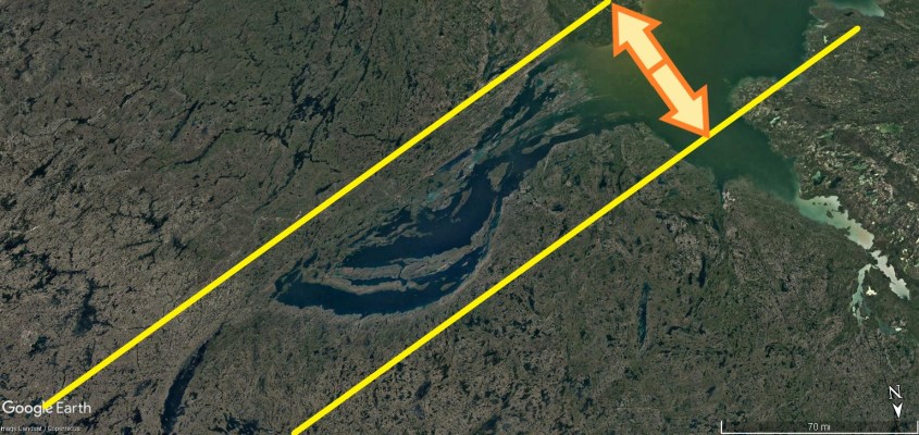
And where the Caribbean Loop has volcanic islands inside the curve of the loop, the North American Loop has maar craters (see “The Maars of Pinacate“), forming a series of circular lakes surrounding the arc of the Great Lakes. Only a few circular, or circular lake formations are highlighted here to show the trend.


Maars are volcanoes created by steam and other gases exploding from heat instead of spewing ash and lava. Smaller such expressions are known as karsts and breccia pipes. They are all forms of diatremes, and are often mined for uranium and precious metals, which the eruption leaves behind in the throat of the tube. The surface result is a crater instead of a cinder cone.
Further east there are long linear lakes, forming striations in the land normally attributed to glaciation. They may well be from glaciation, but the direction and orientation also suggest they could be from a contracting current loop passing below.
There is a large body of evidence for glaciation, and Electric Earth theories do not dispute, or conflict with the evidence. However several landscape features attributed to glaciation may be misinterpreted. These cuts are a possibility.

The implication is that the loop current lies below aquifers that erupted in steam, creating the maars. And that the volcanic expression is to the outside of the loop, depressions to the inside, so current circulates north-to-south in this loop – opposite to the Caribbean Loop.

The shape of the Great Lakes, especially Lake Superior, show the sinuous shape of ground current movement. It appears the loop narrowed, or swung to the south, until the southern leg aligned to the Jemez Lineament.

The Yellowstone volcano lineament is a half circle, and also appears to be from ground current movement. In this case, the movement is north from the Monterrey Micro-plate, to the Juan de Fuca triple junction. This widened the base of the loop, with the pivot point of the shift at the Black Hills of South Dakota.

Tertiary Ground Currents and Surface Dipoles
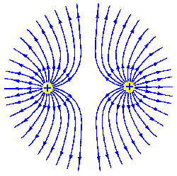
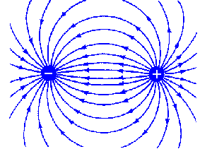
Since we regard volcanoes as electrodes poking through the crust, they should also be considered anodic, as they expel ionic matter. This charged matter is current in a circuit, and electric field lines between two anodes don’t connect – they repel each other. A circuit has to go somewhere, so there also must be cathodes to provide a sink for the currents.
The volcanic anodes spit ions into the atmosphere, so the circuit has to complete through the atmosphere, back to ground. We know how this happens. It’s called lightning. Specifically, “negative lightning”, which you may wish to review in “Nature’s Electrode“.
Where negative lightning strikes, it burns and blasts the land, initially causing a crater. But the return stroke draws positive ionic matter to it, leaving a mound. So a volcano is an anode spitting matter into the atmosphere, necessarily connected to a cathode, which is a lightning spitting thunderstorm drawing in-flow winds and matter to it.
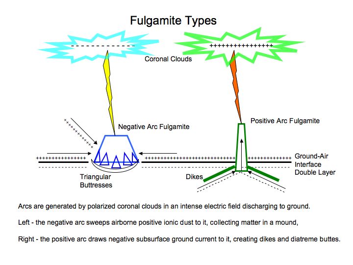
Negative lightning gathers positive surface ions to it, piling-up a mountain. It often produces winds in excess of Mach speed, producing tetrahedral shock features on the flanks. They come in a variety of forms, depending on the severity of the discharge and the material on the ground it affects.
Two prominent lightning fulgamites are juxtaposed, either side of Yellowstone, creating dipolar alignments. The Black Hills to the east, and Sacajawea Peak, in Eastern Oregon. The ground current runs straight through this alignment to the Juan de Fuca plate.

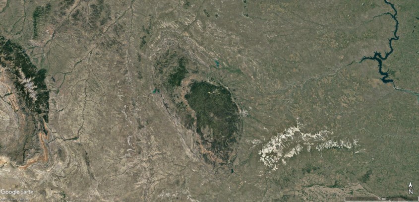

Note that both are very large mountain complexes, with multiple peaks. They form roughly circular mountain lobes surrounded by river valleys, like a moat around a castle.
There are several more of these large fulgamites throughout the Colorado Plateau. Actually, there are millions of them, but most are small and are in proximity to the largest. Mapping the most prominent, along with the most prominent volcanoes, yields a picture of where tertiary ground currents flow.
Remember we have Primary and Secondary ground currents. Now there is a Tertiary current flowing close beneath the ground between anode and cathode spots.
Since we know an electric field between an anode and a cathode – a dipole – produces a field pattern with the maximum voltage gradient directly between them, we can connect volcanoes and their most proximate fulgamites with straight lines and get an approximation of the electric field at ground level.

If you’re having trouble picturing this, think of the electric field as a blanket held in the hands of firemen. The anodes and cathodes are where their hands hold the blanket. Presumably, they are going to catch a victim of a fire jumping from a high window, so they hold the blanket very tight. All the tension in the blanket is between their hands – single lines of tension, like ropes. The rest of the blanket is slack. So, just by knowing where the “hands are” – the anodes and cathodes – you know the basic topology of the blanket.
Now, consider that each of these lines of tension in the ground is just the bottom half of a loop that arches through the atmosphere. One leg of the loop is a volcano spewing, and the other is a raging thunderstorm of biblical proportion, it’s lightning and inflow winds building a mountain beneath.
Through the center of the loops flow jet-streams of induced current plasma. It is simple electromagnetic induction for a current loop to draw a plasma wind through it. So ground-level, horizontal jet streams pour through at ninety degrees to the loop. Consequently, we can draw ground winds perpendicular to the violet lines denoting major dipoles and create a wind map.

And this wind map is eerily similar to the wind map generated from the pattern of tetrahedrons on wind-blown mountains and up-draft dome/down-draft crater pairs mapped in “Eye of the Storm – Part 4“.
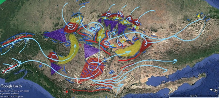
In fact, they produce virtually identical wind maps, except for the fact the electric field model cannot show high level winds. It only shows ground hugging jet-streams.
Mapping up-draft domes and down-draft craters with a true understanding of thunderstorms and cyclones is the only way to find vertical winds and understand the full, three dimensional current path.
So what does this mean? It means the firmament was formed by volcano, wind, lightning and electric fields due to Earth’s capacitance.
The wind is displayed by physical features, such as shock wave patterns that cannot have been formed seismically, or by erosion.

The wind is displayed by ground current paths that produce dipolar nodes of volcanoes and fulgamites.
The wind is displayed by the footprints of up-draft domes and down-draft craters that portray the vertical dimension.
And we have an ongoing, observable laboratory experiment to compare with right here in this Solar system.
Thank you. Please hit the “like” button, if you liked it. Leave a comment, if you dare. Leave some money, regardless.

Quick Tip
The Daily Plasma is free to read, but the cost of publishing isn’t. Please leave a tip to show appreciation, and help defray expenses.
$5.00

I’ve been kicking the idea around my brain that it would be possible to create a system on the ground that would serve as a giant battery. That way you wouldn’t have to pay a lot of money for a conventional type (lead acid, lithium ion, etc…) battery array for your solar/ wind power generating units. Perhaps a variation on the saltwater battery concept incorporating aquaculture.
Any thoughts?
LikeLike
I think it’s worth considering reversing our understanding of the age of the seafloor, that is it expands still from beneath the continents, much of the electrical activity you describe is a consequence of the exothermic chemical reactions taking place at continental margins liberating electrons to create the voltage difference driving the landscaping you see. There are no subduction zones there are expansion zones creating new sea floor and above them the maars or volcanoes, as the chemistry dictates.
LikeLiked by 1 person
Sir- Have you not come across the Pinoqachole WHOLE-EARTH plug? I have several in my Poutine Pub. Given to me by an Electronics friend.They work VERY WELL!
It was originally conceived by Nikolai Tesla, and apparently recently perfected by an associate of mine in Manlyville, Ontario.
Apparently they are even starting to sell them on Amazon! (Canada)
They have a rudimentary website at WHOLE-Earth Plug . But how can I contact them? I lost his cars
LikeLiked by 1 person
Hmmm… my cousin installed a few of these WHOLE-EARTH plugs in her electric outlets. Her spirit did improve, but she says that now she hears strange men’s voices coming from a couple of the plugs. One apparently sounds like Nikolai Tesla, and he is giving her salacious advice, about how he can “supercharge” her aura.
Has anyone here ever of this?
LikeLike
I’m just starting to read your articles. I read your #3 article on thunderbolts.info yesterday and was excited to see how you described things. It matches many of my own thoughts.
I would like to suggest that you check out this video:
When you talked about tornadoes’ updrafts sucking up from the ground (and contrasted how hurricanes downdrafts push down), I thought you should see this video that was taken 5-28-2019 (yesterday) while a tornado was just getting started in Oklahoma.
The video shows condensate being pulled up from some trees into the newly-forming tornado. The meteorologist and the pilot of the helicopter who was shooting the video both seemed quite impressed with the phenomenon.
LikeLiked by 1 person
Thank you for the inspiration. Your work was a catalyst in shaping my own project and I wanted to share my appreciation.
LikeLike
hi, I agree with Electric Earth. I think the terrain formation by the discharge is very wonderful. But I think there is no plate, no core. Earth has hollow and expanding. Your Earth model can not explain for rotation, magnetic fields, or gravity.
LikeLike
#ExpandingEarth
LikeLike
Another great article Andy. Fascinating.
I see that you identify Lake Wanapitae as a maar crater. This is in my neck of the woods and I have long been fascinated by the local geology here.
https://www.greatersudbury.ca/play/beaches-and-lakes/lakes/local-lake-descriptions/lake-wanapitei/maps-of-lake-wanapitei/
The map above shows the lake has an offset somewhat conical shape which I believe is supporting evidence to your hypothesis.
The lake is 466 feet at its deepest in the southern bay. Material erupting from the feature would have shot out at some angle, to the north, which in keeping with the right-hand rule. But I wonder if that material could have been looped back to the south and the entire event might have shaped the local landscape and created the minerals in the Sudbury mining camp, one of the largest Ni Cu and PGE deposits in the world.
Two other features that are prominent and located on either side of Lake Wanapitae are the Sudbury Igneous Complex (SIC) and the Temagami Magnetic Anomaly (TMA). All three of these features are smack dab on the boundary between the Superior Province and the Southern Province. The Grenville Province being just a bit to the south. I don’t think this is a coincidence.
It seems to me that the form of magnetic anomalies in the region seem similar in form to a coronal loop feature I spotted on the sun which was happening at the time of the big CME in 2012.
Would your hypothesis hold that there ought to be mineral deposits in the ‘throat’ of the Lake Wanapitae eruption, that is, below the lowest part of the lake?
Cheers
Don
LikeLike