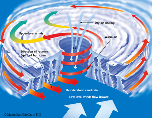
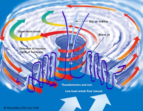
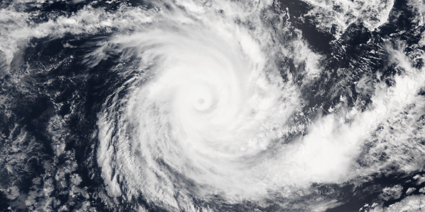
On Earth, hurricanes and typhoons are called cyclones and occur over the oceans. The cyclonic storm develops an eye in the center of rotation, where high altitude, dry air is drawn down the center. The thing to know is that the eye of a cyclone is a downdraft wind.
The center of a cyclone is a downdraft
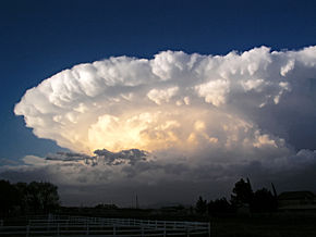
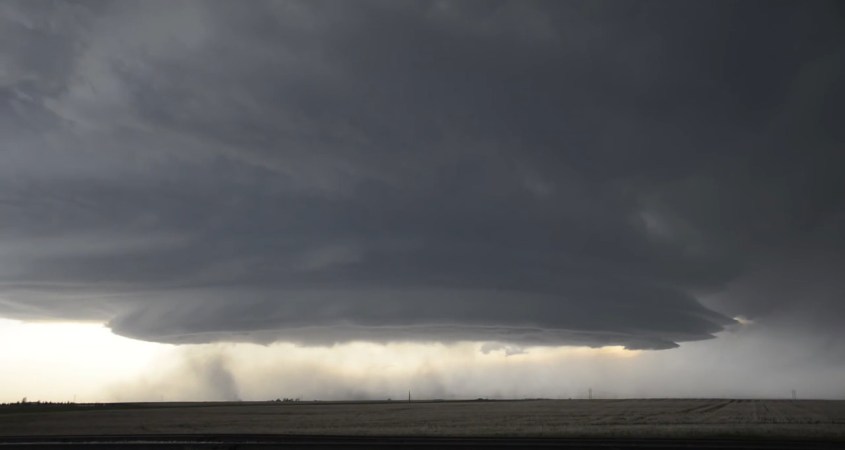
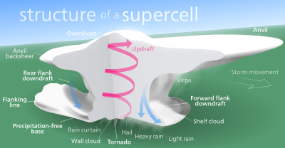
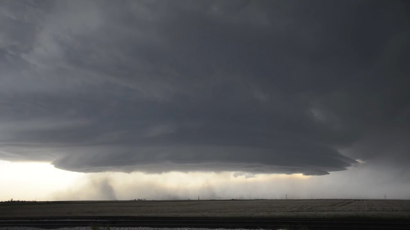
Over land, we see a different effect. Super-cell thunderstorms develop a rotating meso-cyclone that rises in a tower that spreads an anvil cloud. The thing to know is that the center of a thunderstorm is an updraft wind.
Thunderstorms’ central meso-cyclone is a rotating updraft.
If you look at these different storms from above, the cyclone blows at the ground, and the thunderstorm sucks at the ground. The pattern of wind in each type of storm is due to capacitance in the electrical circuitry of the Earth.
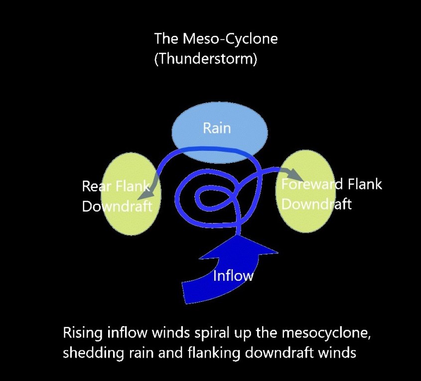
The thunderstorm as a circuit…
The electric winds of a thunderstorm can be likened to a rope. Generally, the rope winds up the towering meso-cyclone to a cap, the anvil cloud, and unwinds from there to non-rotating channels of rain flanked by downdraft winds.
The mature storm forms a circuit – a current loop from ground through the meso-cyclone and back to ground – as rain.
The very pattern of a super-cell betrays it’s identity: It is a stack of dielectric layers through which a current flows. Condensing, and then freezing moisture in the updraft sheds ionized matter into cold plasma currents that produce rain, lightning and tornadoes.
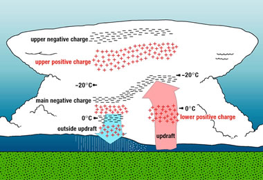
A massive, cold plasma halo in the sky acts like a live electrode hanging over the ground, with an air gap between. The updraft current is from ions swept from ground level. It loops through a negative plasma low in the cloud where condensation occurs, and continues to a positive plasma in the anvil, where ice forms. At each level, the recombined matter – the rain and ice – are shed and return to ground. Flanking down-draft winds are excess currents of uni-polar wind that complete the storm’s looping circuit to ground.
Three Dimensional Jet Streams
Charge densities are responsible for the geometry of storms. As negative charge builds in the bottom wet layers of cloud it strengthens the local electric field and draws winds to it. Above, in the cold icy layers at high altitude, a positive layer of charge accumulates to balance the charge below, and it spreads out in a huge disc.
Thunderstorms central core sucks wind up and diffuses laterally in an anvil cloud.
Likewise, on the ground below the cloud, positive charge accumulates to balance the cloud charge and feed the central updraft. Lightning arcs contribute to balancing the charged layers, dissipating charge at points of highest potential.
But the build-up of charge density around the core of the storm also means there is a secondary vector in the electric field running horizontally through the cloud layers. As ionic matter is drawn to the storm by updraft and concentrated, it depletes charge from the far field region of atmospheric layers, creating local electric fields which draw current horizontally, transverse to the electric field at the core of the storm.
Charge diffuses horizontally, as well as vertically, and the visual evidence is in the symmetry and coherence of the tightly wound meso-cyclone. The base of the storm which draws charge to it – and the spreading anvil cloud which disperses charge away.
Consensus science says the green glow of a meso-cyclone is light reflecting from water in the clouds. Yet the rain curtain, which is water, doesn’t glow green at all. In fact rain clouds that aren’t in a meso-cyclone don’t glow green either, though they are saturated with water too. The green glow is coronal discharge.
Everything about thunderstorm morphology speaks to layers of capacitance in a point-to-plane circuit that loops through an air gap to ground.
Thunderstorm is patterned on point-to-plane discharge geometry
Channels of wind, sputtering and arc mode discharge match channels of coronal discharge
Consensus science has attributed the electrical charge build-up in thunderstorms to “static” charge from colliding rain and ice. One flaw in this idea is: there is nothing static anywhere, at anytime, in any place in a thunderstorm. Everything moves – and that means charge, too. And that means one undeniable thing: electric current. To not model a thunderstorm as such flies in the face of reason.
Fractal Progression
In a hurricane the airflow is very different from a thunderstorm. Consider the wind-flow again as a piece of rope: the rope enters whole down the central vortex, and unwinds into several threads of vertical up-and-down drafts flowing radially away from the storm’s eye in rotating currents.
It’s almost the inverse of a thunderstorm, which has a rotating updraft that unwinds into threads of non-rotating downdrafts and rain.
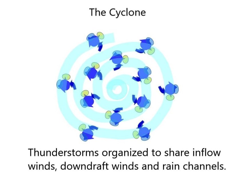
The cyclone’s rotating updraft bands are made of thunderstorms, which electrically, suggests the entire cyclone is a next-level fractal expression of the thunderstorm, in which the independent loops of thunderstorms’ maintain their form, but have organized together creating loops within loops, and vortexes within vortexes – fractal repetition of form.
In fact, thunderstorm cells interact as looped currents all the time, even when not part of a larger cyclonic system. One storm cell can arch it’s anvil cloud over another, and suck the life out of it by absorbing its energy. One can witness this as squall lines of thunderstorms develop.
Comparing the characteristics of thunderstorms and hurricanes (northern hemisphere) shows the similarities and polar opposite characteristics that naturally develop in this fractal progression:
Attribute
Thunderstorm
Hurricane
Surface Condition
Over land
Over ocean
Central Core Wind
Wet, hot, rotating updraft of condensation
Dry, cold, non-condensing, non-rotating downdraft
Outer Winds
Non-rotating, dry downdraft winds flanking a rain curtain
Circumferential rotating wet updraft winds and rain bands
Rotation
Counter-clockwise central updraft meso-cyclone, wall clouds and tornadoes rotate in the core of the storm
Counter-clockwise, outer winds and rain bands rotate around the central downdraft core of the storm
Discharge modes
Vertical winds, lightning and tornadoes
Rotating wind. Cyclones produce very little lightning and comparatively weak tornadoes.
In a hurricane, thunderstorms organize like synchronized swimmers swimming in a circle, creating a whirlpool down-draft in the center. The organized entity has more power than a meso-cyclone, but it’s diffused over a greater area and creates less tension in the electric field.
Vertical winds of thunderstorms in the rotating bands dominate the structure of a cyclone.
Super-cell thunderstorms are small in comparison to cyclones, but create a higher electrical tension that produces far more lightning and powerful tornadoes.
One reason a cyclone is different from a meso-cyclone is that cyclones form over water. The electrode spot on a featureless, homogeneous surface of ocean diffuses charge broadly and evenly. On land, there are mountains, mineral and water deposits that ‘focus’ the electric field, by providing greater conductivity, or increasing charge density at elevations.
A similar relationship exists between thunderstorms in mountain regions and the super-cells on the plains that produce horrendous tornadoes. Mountainous regions rarely produce tornadoes because high points and mineral deposits collect charge, increasing the electric field tension to draw arcs of lightning. The diffusion of ground charge on flat plains allows discharge between ground and cloud to spread out, which favors spinning Marklund plasma currents instead of intense bolts of lightning. The tornado is a more diffused, slower, less intense discharge than a lightning bolt, but still a fractal element of discharge within the thunderstorm.
The cyclone is a fractal step-up in scale from the meso-cyclone. It isn’t just a bigger thunderstorm, it’s a whole new entity composed of the old entities, re-organized into a higher level of complexity. It’s like striking one octave above a note and finding harmony – two notes in resonance that create a new sound, more complex than the sum of each note.
The cyclone is the next level of storm complexity, where the thunderstorm cells act in harmony and begin to share lanes of updraft and downdraft winds, manifolding together and developing a coherent rotation. Ultimately this forms an eye with a downdraft in the center, and a cyclone is born.
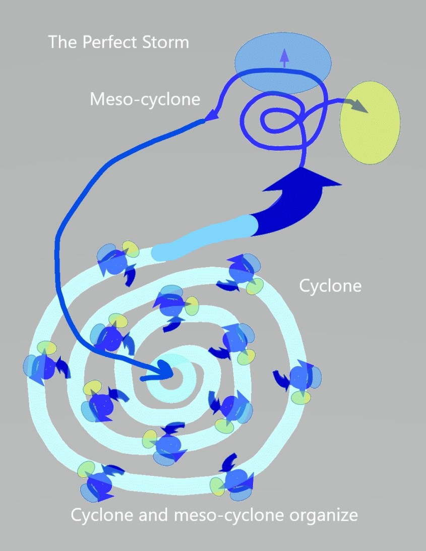
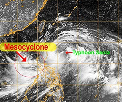
But a cyclone is not the most powerful level of fractal progression for storms on Earth. The next fractal level of plasma form is when a cyclone and meso-cyclone organize. This creates the most destructive storms of all, at least that we see today.
A “Perfect Storm”
In our historic period we don’t see storms that exceed the level of the so called, “Perfect Storm”. Like the famous book of that name, which described the last voyage of a fishing boat caught between such storms, where a hurricane and nor’easter met.
When meso-cyclone and cyclone come together, they produce a loop current. It’s fractal progression of the thunderstorm current — updraft to downdraft and rain. Only one big meso-cyclone connected to a cyclone makes one big current. Outflow at ground level from the cyclone feeds the meso-cyclone, and discharge from the high level anvil feeds the cyclone’s eye. Coherency emerges from plasma actions expressed at every level of the storm in greater and greater complexity.
In our present climate on Earth, “The Perfect Storm” is as bad as it gets. But we are only seeing an echo of the drama of primordial storms. Even though we see lightning and devastating three hundred mile-per-hour winds – violent enough to destroy our matchstick homes – it does not scour us with supersonic winds, hot plasma tornadoes and electric arcs that shape mountain ranges.
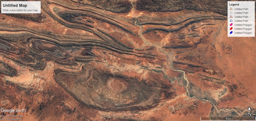
But it did, at some point long ago. Updraft winds of meso-cyclones and downdraft eyes of cyclones became supersonic jet-streams. An energized geomagnetic field amplified the magnetic flux in coronal loops generating co-rotating storms that sucked and blew at the land, leaving vast craters and domes. The ring currents multiplied, too, generating smaller harmonic repetitions – more intense fractal repetitions that produced hot, probably glowing plasma tornadoes and incredibly huge arcs, large enough to boil a mountain from the earth.
As fractal evolution progresses with the application of a larger electric field, thunderstorm cells multiply and their downdrafts grow to cyclones, until multi-vortex systems spin within multi-vortex systems, which are within a multi-vortex system. Nested fractal repetition of form.
We sense winds as horizontal. We describe them that way: nor’easter, westerly, windward and leeward. We rarely think of vertical winds unless we are right under them, and then it is considered an unusual and often catastrophic event. Down-bursts, tornadoes and related vertical effects; lightning and storm surge, are the most destructive elements of storms. Vertical winds impact smaller regions, but are far more violent than horizontal winds.
In primordial storms, vertical winds literally blow-torched the land, and sucked at it like a vacuum hose. We can see this in the geology.
Australia
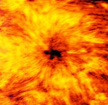
The Solar Example
Strip away the hydro-dynamics of a dense atmosphere, fully ionize the environment to see the raw electric currents in a hot plasma, and it’s like an x-ray view of a storm.
Sunspots are Solar Hurricanes
Sunspots are Solar hurricanes. The central core is a downdraft wind diving beneath the chromosphere. The filaments radiating from the core are coronal loops, attached at one end to the core, and the other to plasma “thunderstorms” – the updraft leg of the loop, which are positioned in a circumferential ring around the core, feeding it filaments of current.
Coronal loops are current discharges along magnetic field lines feeding the core downdraft of a sunspot. The loops are currents trying to break through the Solar atmosphere. When they do break through, it becomes a Solar flare.
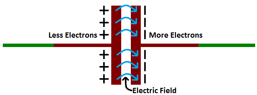
Capacitors are used in electronics and power supply systems to control current flow. They are composed of two conductive plates facing each other with a gap between. The gap is filled with a dielectric material that resists current flow. In its intended operation, current does not pass through the dielectric. Current results from charge build-up and discharge from the plates on either side of the gap.
The hows and whys of a working capacitor are fascinating, but what we are interested in for this discussion is how a capacitor fails. A capacitor fails when current actually flows through the dielectric. It’s termed dielectric breakdown, and occurs when the voltage applied to the capacitor exceeds it’s capacity to store charge on the plates. The dielectric fails to resist the electric field across it and it sparks. That is what we see when lightning strikes – the dielectric breakdown of the layer of air between a cloud and ground. An ionized channel develops in the dielectric and the built-up charge on the plates suddenly dumps through the channel.
Coronal loops form as current tries to break through the Solar atmosphere.
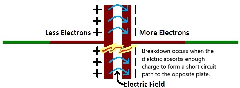
We see the discharge as almost instantaneous, but in reality there is a prior period when the dielectric absorbs charge and builds the ionized channel. Charge has to diffuse through the dielectric before the channel forms and connects the plates. The diffusion of charge through a spherical capacitor, like the Sun’s atmosphere, creates current loops within the dielectric. As charge is absorbed by the dielectric, it forms currents that loop from one plate into the dielectric, and back to the same plate, because they have no path yet to reach the other plate.
As voltage increases, the loops grow (absorption) extending the ionized path further and further, until it breaks through the atmosphere and discharge occurs.
Solar flares occur when the current breaks through.
In storms on Earth, the same looping current flows are in the form of weak plasma winds because the atmosphere is only partially ionized. Cold plasma is mixed with neutral species, so thermo-electric and hydro-dynamic effects come into play, raising complexity, but the underlying electric circuit is the same.
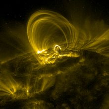
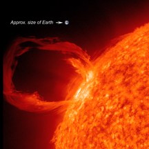
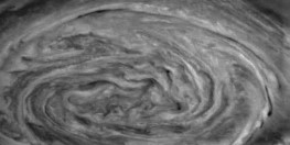
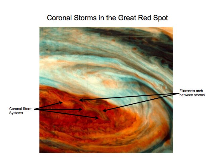
On Jupiter, the same electrical process can be seen occurring, and current loops, or coronal loops can be identified in the Great Red Spot. They appear as Roman colonnades of arches in the cloud, which rise in towering pillars, arch across the sky, and downdraft into the eye of doughnut-shaped cyclones.
Unadulterated view of the The Great Red Spot.
The arching clouds portray the current loops in a multi-vortex coronal storm. They march around the inner rotation the way thunderstorms circulate the eye of a hurricane. Each doughnut-shaped cloud at the base of an arch is a cyclone of giant proportion with a downdraft through its core. The other end of the arch is the towering updraft of a thunderstorm, and the filament that arches between is the anvil cloud following current flow along a loop connected to a dielectric surface below. They are the tops of vertical ring currents – coronal loops – that are so intense they sculpt the anvil clouds in the shape of the current flow.
NASA can detect these jet stream winds. They are aware of the complex patterns and the violent up and down drafts in the Great Red Spot. Unfortunately, they don’t understand electricity, and so are scratching their heads over the obvious.
The colorized NASA images shows two rows of updraft/downdraft loops riding along the outer circulation of the red region. The entire red region is the giant hurricane with concentric rings of thunderstorms. At the bottom of the red region, the pattern of a double row of arching clouds continues, but the arches are stretched by the rotation of the entire system.
Above the red region is a white shelf cloud that itself has a single, large, counter-clockwise rotation. This is the anvil cloud of a singular giant thunderstorm, and together with the giant cyclone, form one ultra-large “perfect’ storm”.
On Earth, at ground level, these kind of looping currents of cyclone/mesocyclone produced supersonic updraft and downdraft winds that created domes and craters on the land. The jet-stream winds rode up and down these current loops like a yarn crocheted, up and down, through and around, but always folding into an ambient rotation counter-clockwise.
So, with this in mind, in the next installment of Eye of the Storm, we’ll look at a wind map of North America, and see the evidence of Earth’s electric winds.
Have you ever wondered what causes lightning? There’s no wire in the sky, no battery terminal, so where do those giant sparks come from? What’s going on up there?
Don’t expect an answer if you ask. Science seems to avoid the issue. In fact, you won’t find a real explanation outside of the Electric Universe.
The following image is from NOAA, and portrays the consensus theory. As you can see, it shows electrons collecting into a funnel, like marbles in a sink, accelerating down a slippery slope into what looks like a drain. Apparently gravity is hard at work, as usual in the consensus world.
This came from a popular science blog, authored by a physicist, no less. The article did point out that a bolt of lightning needs a billion-trillion electrons, or electron marbles as they like to portray them. But it didn’t even try to explain this drainpipe business. Where do we see electricity act like that?
Ummmm… Nowhere.
The consensus notion (it shouldn’t be considered a theory) is that charge builds in thunderstorms because of static electricity. Hail stones and rain colliding in the updraft generates the static charge, like when you rub a balloon against your hair, or shuffle your feet on the carpet. We’ve all seen five-mile long sparks come out of our fingertips when we reach in the clothes dryer, right?
Positive and negative, statically generated charged particles separate into layers according to the consensus notion – it’s never talked about how this happens. The layers where they are found “pooling” are at distinct thermal boundaries. So it’s thought these thermal boundary layers somehow keep the pools of charge apart, except when they fall into the drainpipe.
It’s a non-answer answer. No one has generated lightning by stirring hot and cold air around and rubbing hailstones together. Generating arcs even a fraction of the size of a lightning bolt generally requires lots of large gauge copper wire, big generators, and courage.
Nor has anyone stratified layers of arcing static charge in atmosphere using wind and humidity. The consensus explanations are scientifically inadequate. Considering lightning was first studied by one of the pioneers of modern science, Ben Franklin, over two hundred and fifty years ago, it’s absurd that science still can’t explain what is going on.
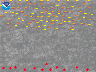
One of the problems is depicted in the above NOAA image of a super-cell, where layers of charge are shown stratified inside the cloud. To acquire enough charge for a single lightning bolt – a billion-trillion electrons worth – the charge density required implies a plasma is involved.
You can call this simple, deductive reasoning. It only takes 1% of neutral air to be ionized for it to behave as a plasma. A billion-trillion electrons has to be concentrated in the cloud more than that before it can spit a thirty-thousand amp, sixty-thousand degree, five kilometer long column of fire. Lightning genesis requires a plasma, because that is what forms the “electrode” in the sky. But you’ll never hear that from NOAA.
So forget them and let’s consider how, why and where plasma forms to play a role in making lightning.
Electric Sky
Earth’s atmosphere is an electric circuit. It carries charge, current and voltage. The air is a weak conductor with a variable, vertical current between the ground and the ionosphere of 1 – 3 pico-amps per square meter. The resistance of the atmosphere is 200 ohms. The “clear sky” voltage potential averages 200-thousand volts between Earth and sky.
At any given moment, there are about 2,000 lightning storms occurring worldwide. To create lightning, the electric field potential must overcome the dielectric breakdown of air at 3 million volts per meter. It can do this because the electric field in a thunderstorm jumps to 300-million volts. A typical lightning bolt momentarily delivers about 30,000 amps to ground. The collective current from a typical storm delivers an average current from .5 to 1 amp.
Therefore, the circuit is completed – Earth to sky, and sky to ground. Only it isn’t, because there is also an exchange from atmosphere to space, and space to atmosphere. This has yet to be accurately measured, or understood. The existence of plasma discharges from thunderstorms to space, called Sprites, Elves and Gnomes for their brief and ethereal appearance, is a relatively recent discovery. Their power and frequency is still an immature study.
Cosmic rays enter the atmosphere, adding charge continuously. The rate Earth is exposed to solar wind fluctuates widely, both because the Solar current fluctuates and so does the strength of the Earth’s magnetic field. Sometimes the shield it provides moves around, letting more cosmic rays enter through “holes”.
Because of this variability, we really can’t say we understand how much current is entering, or leaving Earth’s atmospheric system from space.
The ground also carries potential that varies. Except for the monochrome view of seismic returns, we can’t even see what is below the Earth’s crust to comprehend the flow of current there. Nor whether, how, or where Earth’s current might enter the atmosphere. For electricity, boundary layers like the Earth’s crust isn’t an impermeable barrier, it’s an electrode.
There is a “cavity” defined by the surface of the Earth and the inner edge of the ionosphere. It’s been calculated that at any moment, the total charge residing in this cavity is 500,000 coulombs. The 2,000 concurrent lightning storms, each about an amp-and-a-half, means this worldwide charge is flowing at about 3000 amps between the ground and sky.
Electromagnetic waves reflect from the boundary of the cavity – the ground and ionosphere – and establish quasi-standing electromagnetic waves at resonant frequencies. W. O. Schumann predicted the resonant properties of the cavity in 1952, and they were first detected in 1954. They are called Schumann’s resonances and are measured as broadband electromagnetic impulses at frequencies in the range of 5 to 50 Hz.
The atmosphere is undeniably electric. It’s not a few ions benignly floating around in the air, but a globally active and coherent current flow. What should that tell us about lightning? Mustn’t it also be part of this coherent resonant system. Doesn’t it beg for a better model than marbles in a drainpipe?
Fortunately, there is a model to look to. It’s called electronics.
Atmospheric arcs created in a circuit are generally recognized to occur by thermionic emission. Everyone has seen a hot cathode arcing, as in a welding arc, where electrons are freed from the metal surface of the electrode by heat. The metal is heated by its own resistance to current, and begins emitting electrons above a certain temperature threshold specific to the electrode material. The temperature for many materials is thousands of degrees.
Another form of discharge less well recognized is field emission, or cold cathode emissions. They do not generate electrons by thermionics. The electrode warms, but not appreciably because heat is not what frees the electrons. It’s the electric field strength – a high voltage potential, that strips electrons from whatever material is present, including the air itself.
When this happens, the field forms ionic matter into a plasma structure, called a corona. Corona is the electrode in the sky that discharges lightning.
Coronal discharge is used in a variety of ways in modern technology. It requires a high voltage, which is precisely what is present in a thunderstorm – 300 million volts, or three orders of magnitude stronger than in clear weather. One would think that for an electrical storm that spits five mile long arcs, this factor would be considered in the structure and actions of the storm.
Not so, say the consensus. It’s caused by layers of cold, dry air and hot, humid air colliding, convection to stir it up, some hail to rub together, and viola… there be electricity.
Corona is truly the only known electrical phenomena that can result in a non-thermionic discharge under atmospheric conditions. The electric field rips the air into a plasma and the plasma forms a corona. It’s an integral part of the thermoelectric current and the generator of lightning.
Corona occurs in a layer perpendicular to the electric field, where the field strips electrons from atoms, sending them downward at near the speed of light along the field gradient, to collide inevitably with another atom.
The collision strips more electrons free to follow the electric field and leave behind ions. The region where electrons are stripped, leaving ionic matter, is a cold plasma, which self organizes into a corona, because that is what an excited, discharging plasma does.
Free electrons continue the process of collision in what is called an avalanche. Avalanche is portrayed in the step-leader process depicted in the image, and is a witnessed precursor to a lightning bolt.
The avalanche is one half of the picture, however. Lightning comes from below, as much as from above. The electric field also pools positive ions on the ground below the storm, which itself becomes a cold, partial-plasma corona. Ionic streamers, filaments of positively charged air from this corona, stretch up the electric field towards the clouds. A lightning bolt occurs when the cascading step leader and streamer meet, completing a plasma channel.
None of this is seen with the naked eye. It’s all dark current up to this point.
The lightning channel is complete when the avalanche connects with a ground streamer. The connection allows a dump of electrons from the corona to ground. Then, heavier, and significantly slower ions, carry up the channel in a return stroke.
The return stroke can be seen in the image as the bright flash that occurs the moment the first tendril of the avalanche current strikes Earth, leaving only one path glowing after the flash.
Corona provides the reservoir of charge and the dark current mechanism for avalanche required to make an arc. This is what is missing in the consensus notions.
It’s also worth noting – when you see a news report about lightning killing a herd of cows, elk, or reindeer, they are always found piled together. The reporter will say, they were huddled together for warmth in the storm, or some such. The reason is they were all part of the positive coronal return stroke – as charged bodies, they got pulled into a pile by the lightning.
Water is self-ionizing. Water in its liquid state undergoes auto-ionization when water molecules combine – as in condensation – to form one hydroxide anion (OH-) and one hydronium cation (H3O+). Water can further be ionized by impurity, such as carbon dioxide to form carbonic acid. Therefore, water condensing into clouds in a monster electric field provides an ionization event. The E-field strips the ions apart as they form.
Water in a thunderstorm goes through all of it’s phases. From water vapor, to cloud condensate, to rain droplet, to ice. The structure of a thunderstorm is oriented vertically around a large central updraft. The phase changes occur in layered strata of increasingly colder temperatures.
Water can become supersaturated – rising above 100% relative humidity if air is rapidly cooled, for example, by rising suddenly in an updraft. The supersaturation instability provides another opportunity for ionization.
Ice is typically a positive charge carrier, meaning that current flows over its surface in streams of positive ions. Flash freezing water onto ice, as hail stones grow, provides another opportunity for ionization.
Each layer of air in a storm has different temperature, humidity, pressure and velocity, transporting different phases of water at different partial pressures, which means the conductivity of the air is changing too. This effect we discussed already as the cause of the thermoelectric engine in the thunderstorm.
If you know any commercial, or military pilots who have flown through the heart of thunderstorms, ask them if they saw the corona themselves, glowing on parts of the airplane.
This is still only part of the matrix of cause and effect that makes thunderstorms. The storm clouds are a corona – the interior of the clouds contain cold plasma. Corona are the result of current in the updraft driven by the thermoelectric effect, and water condensing and freezing. All of the effects of lightning, tornado, rain and downburst wind is a form of electrical discharge from the corona.
The specifics of a tornado will come next in the discussion. There is more to discuss about lightning and winds, also. There are different types of lightning which come from different corona, but we’ll pick-up on that when we get into geology.
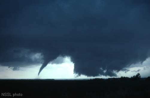
People who witness a tornado never forget. They may recall awe and beauty, or awe and terror, depending on their vantage point. Either way, they will be awed and it will haunt them forever.
For many, it becomes an obsession. An obsession to watch, film, chase, drive beneath – a need to understand. Or else, an obsession to hide every time the wind howls.
A tornado is nature’s demon. Winds in rotation, tight as a knot, with a body and energy that give it life, coherency, and a dislike for trailer parks. Most terrifying of all, it will chase you down, suck you off the ground and spit you back naked, muddy and dead.
That’s demonic.
It’s size and power seems to materialize from thin air. And it does. It’s nothing but air, at least until it picks you up, along with tons of dirt, cars, buildings and cows. All are then part of the coherent, rotating structure.
But is it really just air, spinning like a top – or is there something too organized about the mayhem – something we still don’t know?
The Mystery…
No one fully understands tornadoes. Scientists and weather nerds chase them all over the Midwest every spring; they can’t hide. So what’s the mystery?
There are a few, but the primary one is how this coherent mass of rotating air gets vertical and ‘descends’ itself to the ground.
Tornadoes are believed by consensus science to be a purely thermodynamic event, caused by convection of moist, warm air into cold jet streams above, and the shear winds and condensation that results.
It’s no reach to understand how shear winds generate rotation, but the shearing in thunderstorms tends to be drafts traveling up and down, and cross winds at different elevations. Either shear can produce rotation, but only in the horizontal plane.
The theory approved by consensus science for grade school education, is that the column is created by shearing horizontal winds, one over the other, that create a horizontal rotating mass that gets lifted and stretched by updraft winds into a vertical vortex. What they don’t tell the grade-schooler’s is that the physics doesn’t work.
The Consensus Notion
To illustrate the issue, think of a similar vortex, like a whirlpool in a bucket of water. If you stir the water with a spoon near the surface of the water, at first no whirlpool appears.
Keep stirring…
After awhile, when you have water rotating at the top of the bucket, the vortex forms. But it won’t extend any deeper than where the water is rotating. It won’t reach bottom until the rotation translates downward and the whole bucket of water is spinning.
If you want to make a whirlpool fast, put the spoon all the way down and stir at the bottom of the bucket. Then it forms quickly, like opening a drain. To ‘descend’, the vortex needs to be pulled down by the low pressure created by centrifugal effects of the rotating water around it. If the bulk body of water around the vortex isn’t rotating, the funnel loses coherency and dissipates.
What is really happening is the vortex is created at the bottom of the bucket when you stir, and the funnel descends to meet it. The vortex has to be there first, and made to spin faster to draw the void of air down, which is the funnel we see.
So, one might ask, isn’t the funnel sucking like a straw and pulling itself down a column of air like a climber on a rope? Does your vacuum cleaner hose pull you down when you hold it a foot, or so above the ground?
No, there is nothing for it to pull on. The air beneath the hose keeps getting replaced as fast as it’s sucked in, so there is no tension created. A sufficient low pressure region can’t develop beneath the hose to provide any force unless you hold it less than an inch away from the ground, where friction can slow the inflow and generate a region of low pressure between the hose and the ground.
Just like the whirlpool, there needs to be a low pressure region to pull the funnel down and vortex winds at ground level. Before a tornado touches down, these winds need to be there. But there is often relative calm before a touchdown. All hell doesn’t break loose until after.
Consensus Theory #1…
Yes, it’s usually counter-clockwise, but I’m not going to redraft it.
Some researchers do predict rotating ground winds initiate tornadoes. The appearance of descent is really not the swirling winds of the tornado, but the visible condensation forming in the low pressure inside the vortex, and this condensation descends as the vortex ‘spins-up’, rotating faster.
In this concept, the tornado’s wind is already there in a compete column surrounding the descending condensation. It’s thought the tornado is initiated by a ground level vortex wind and this ground vortex controls the spin of the tornado.
Inflowing ground winds are certainly in the equation during the tornado’s life. But before touchdown, the existence of a ground vortex hasn’t been verified. It’s thought to be at low wind speeds, below speeds that would cause damage. It’s not until this ground vortex spins itself-up enough to start lifting dust that the tornado technically ‘touches down’ and we notice it.
The issue with this theory is that rotating funnel clouds are commonly seen that never seem to touch down at all, or be associated with ground winds, which implies they are rotating up there by themselves caused by something other than a ground vortex. This puts tornadogenesis back in the clouds.
Even in the event a subtle ground vortex is involved in creating a rotating column, how does this ground vortex form? Data is lacking because no one can predict where a tornado is going to land in order to set up the instrumentation.
Consensus Theory #2…can it still be a consensus?
Another theory proposes that the vortex is drawn to the ground when a descending column of air and rain wraps around a funnel cloud.
It’s called an occlusion downdraft, and it’s commonly seen, but not always. The theory requires the rainy downdraft wrap around the funnel to form a concentric vortex that merges with the funnel cloud and creates a smoke ring effect, a torus of rotating winds, with a longitudinal momentum that drags the funnel down. No photographs of this torus exist, as far as we know.
It sounds like a complex process. Too complex to explain several types of tornado that form when the mechanisms required aren’t there. Non-supercell tornadoes, albeit typically weaker, form when the conditions required for rain-wrap aren’t present.
Strange behavior…
Non-supercell tornadoes are circulations that do not form from organized storm-scale rotation. These tornadoes form from a vertically spinning parcel of air already occurring near the ground.
One non-supercell tornado is a landspout. A landspout is a tornado with a narrow, condensation funnel that forms while the storm clouds are still growing and there is no rotating updraft – the spinning motion originates near the ground.
Waterspout
Waterspouts are generally classified as non-supercell tornadoes. Waterspouts have a five-part life cycle: a dark spot on the water surface, spiral pattern on the water surface, a spray ring around the pattern, a visible condensation funnel, and ultimate decay.
Again, the life cycle begins at the surface, when a “dark spot” forms. They normally develop as their ‘parent’ clouds are still in the process of development.
Waterspouts are known for raining fish. From as deep as three feet below the surface (how do they know this?) fish can be lifted into the air and deposited as far as 100 miles inland.
Tornadoes display other perplexing behavior. Witnesses claim seeing tornadoes die suddenly and another rapidly form in apparently the same track as the previous.
Did they see one tornado fluctuating in strength, or two vortexes in sequence? The disappearance and reappearance is so rapid it is hard to imagine the atmospheric dynamic that would cause it.
Mounting evidence, including Doppler mobile radar images and eyewitness accounts, show most tornadoes have a clear, calm center with extremely low pressure, like the eye of a hurricane. The mystery of this is why it surprises anyone, but it’s still fascinating.
What follows is an excerpt from a 1930 report by Mr. Will Keller of Greensburg, Kansas, eye witness to the inside of a tornado:
“Steadily the tornado came on, the end gradually rising above the ground. I could have stood there only a few seconds but so impressed was I with what was going on that it seemed a long time. At last the great shaggy end of the funnel hung directly overhead. Everything was as still as death. There was a strong gassy odor and it seemed that I could not breathe. There was a screaming, hissing sound coming directly from the end of the funnel. I looked up and to my astonishment I saw right up into the heart of the tornado.
There was a circular opening in the center of the funnel, about 50 or 100 feet in diameter, and extending straight upward for a distance of at least one half mile, as best I could judge under the circumstances. The walls of this opening were of rotating clouds and the whole was made brilliantly visible by constant flashes of lightning which zig-zagged from side to side. Had it not been for the lightning I could not have seen the opening, not any distance up into it anyway. Around the lower rim of the great vortex small tornadoes were constantly forming and breaking away. These looked like tails as they writhed their way around the end of the funnel. It was these that made the hissing noise.
I noticed that the direction of rotation of the great whirl was anticlockwise, but the small twisters rotated both ways – some one way and some another. The opening was entirely hollow except for something which I could not exactly make out, but suppose that it was a detached wind cloud. This thing was in the center and was moving up and down.”
There are other types of tornado-like phenomena. Gustnado’s that form at storm fronts display the characteristics of a tornado touchdown, kicking up dust and debris in a vortex on the ground, but without any apparent rotation, or funnel above.
Sometimes without even clouds above. Dust devils also form this way. Isn’t there a common dominant influence underlying all these atmospheric whirlpools?
Now let’s remember that we live on an Electric Earth…
Take the blinders off, and see if there is another way to look at tornadoes.
By taking blinders off, it means adding electromagnetism back into the picture. It has been excluded almost completely by consensus science, even though it is the most pervasive feature of thunderstorms – the very things that makes tornadoes.
The word tornado is an altered form of the Spanish word tronada, which means “thunderstorm”. This in turn was taken from the Latin tonare, meaning “to thunder”. So even the etymology recognizes the obvious, fundamental connection that many, in influential positions, miss. With that in mind, let’s digress a moment to discuss lightning.
Atmospheric Circuitry…
We don’t notice what’s happening electrically in our atmosphere, because we live on the earth’s surface in an equipotential layer. We don’t notice, that is, until a thunderstorm arrives.
Our atmosphere carries an electric field. The atmospheric field varies widely – from night-to-day and summer-to-winter – between 100 volts per meter vertically in clear weather, to orders of magnitude stronger during thunderstorms.
Dust devil
For example, dust devils have been researched by very dirty scientists who measured a vertical electric field gradient of 10,000 volts per meter, even in small whirlwinds. They also found them to produce radio noise and a fluctuating magnetic field at frequencies of 3 to 30 Hz.
Since no intrepid storm-chaser has yet stood under a tornado with an antenna and voltmeter (not for lack of trying) we don’t know the potential in a tornado. Assuming an average tornado column to be three km long and carrying the same potential gradient over the column, that would be a 30 million volt potential. That’s two and half million car batteries connected in series.
A strong electric field will lift materials off the ground and into the atmosphere. Field experiments indicate that a large dust devil measuring 300 ft across can lift about 15 tons of dust into the air in 30 minutes.
Electricity is also known to aid formation of sand storms on Earth, and NASA believes it to be instrumental in raising dust on the Moon, dust devils on Mars, and tornadoes in the atmosphere of the Sun.
Normally the atmosphere carries a minor fair weather current of one pico-amp per square meter. This tiny current is thought to be a return current caused by lightning around the world, diffused throughout the atmosphere. This tiny, diffuse current is only part of the return circuit in a lightning bolt, however.
Keep stirring…
NOAA Image
Lightning from a thunderstorm has no ‘electrode’ in the sky. It comes from accumulations of charge in the clouds – pools of electrons, or ions, like the accumulated charge on a capacitor plate.
Temperature and pressure moved by shearing winds take the place of the plates in segregating regions of charge.
A study using interferometer and Doppler radar to correlate lightning with updraft and downdraft winds, showed that lightning avoids the updraft core (red arrow in the image) and forms in regions of weaker, lower pressure winds around the updraft. As a storm intensifies and the updraft speeds up, lightning frequency dramatically intensifies.
Fast updraft winds and their role in supercell structure is a discussion for another day, however it will be shown they are likely motivated by electric current in the storm in the first place, so it is not surprising in an electric atmosphere that positive ions in a powerful updraft would collect negative charge around the updraft column, which is where the study found lightning to initiate.
Updraft winds don’t produce much lightning until they reach 10 to 20 mph. Then strike frequency escalates with updraft speed. From 20 to 50 mph wind speeds, lightning frequency might be 5 to 20 strikes per minute, whereas above 90 mph, the flash rate can exceed one strike per second.
It’s like a motor running.
Coincidentally, cloud-to-ground lightning frequency is seen to decrease as a tornado touches down, and return to the baseline level when the tornado dissipates. This is an important point, but we’ll return to it later.
The charged layers in the cloud, and the thin, flashing filament we see in common cloud-to-ground lightning, is only part of the event. There is also buildup of positive charge on the ground. The ground charge forms as a pool of positive ions over the surface of the land and its features, accumulating in concentration at high points. The positive ions form when electrons are stripped away from air and surface features by the powerful electric field.
The lightning bolt initiates when the negative charge invades the air below with filaments of charge called leaders. Remember, there is an amplified electric field of millions of volts between the storm clouds and Earth. The leaders zig-zag downward in stepped segments while the ground charge reaches up in a filament of positive ions called a streamer. When leader and streamer meet, the channel is complete and dumps the negative cloud charge to ground. This is called an arc discharge.
Electrons flood through the channel at relativistic speed, creating a magnetic field that constricts the channel and the current, called a z-pinch. It is the dielectric breakdown of atmosphere to allow a discharge – a short circuit between the clouds and ground.
The ionic ground charge follows, ions being heavy and therefore slower than electrons, rushing up the channel at 60,000 miles per second in what is called a return stroke. It’s the return stroke we see emitting light from particle collisions in the constricted channel. Return strokes often repeat as new charge pools and discharges, producing multiple flashes until charges equalize.
It all happens within tenths of a second, involving volumes measured in cubic kilometers. So these charged layers in the clouds and on the ground must be highly coherent.
Dark – Not Arc…
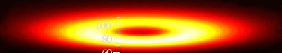
Arc discharge is the extreme end of the spectrum for electrical discharge, however. There are other types of discharge that occur under different regimes of electric field intensity, charge density, and the polarity and physical properties of the electrodes and medium the discharge takes place in.
The channel lightning travels in is a fully ionized plasma generated by the strong electric field between the cloud and ground. The leaders and streamers are the plasma channel being created. Other modes of current flow can occur without dielectric breakdown, or full ionization of the plasma. These currents don’t create an arc of lightning.
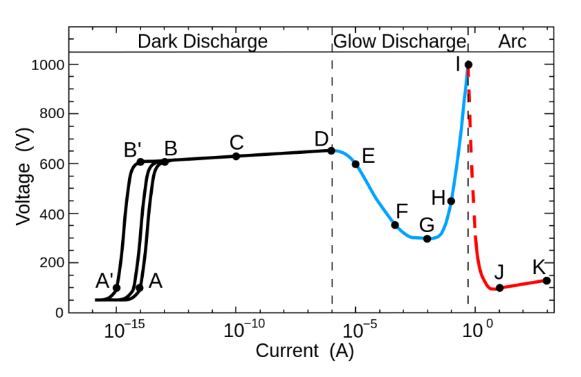
Glow discharge in a Plasma
The chart above demonstrates that extremely high current is required to make an arc, (red part of curve). Medium currents produce only a glow, like the polar aurora and neon lights (blue curve). Low currents will produce no light emission at all (black curve).
From ‘A’ to ‘B’ is a regime of discharge initiation, where reactions are taking place to saturate the channel with ionization. Then from ‘B’ to ‘D’, current rises exponentially with very high voltage. Current density is low enough though, there are few particle collisions and it emits no visible light. This is the regime of dark discharge, or dark current mode, and it’s invisible.
Cosmic ray creating an avalanche.
In this region, the high electric field gives electrons enough energy to ionize a neutral atom, releasing another electron which initiates a chain reaction. The new free electron ionizes another neutral in a secondary reaction and this continues, leading to an avalanche of new ion and electron production. The avalanche results in the exponential current rise as charge density amplifies. It’s called a Townsend discharge.
When current is high enough, visible glow can occur near the electrode and edges, sharp points, or other narrow objects where charge collects. This is called corona discharge. One form of corona discharge is St. Elmo’s fire.
Another glow discharge related to corona discharge is dielectric barrier discharge between two parallel plate electrodes. Both occur at high voltage, low current in atmospheric air below the dielectric breakdown threshold, and without the explosive blast and temperatures of an arc.
A dielectric barrier discharge, shown above, demonstrates how current collects itself into plasma streamers. The discharge is occurring in air between two parallel electrode plates layered with mica at about 30 kHz, with a discharge gap of about 4 mm. The wide foot of the discharge is ionic charge pooling on the barrier surface.
Cold, Dusty Plasma…
For air to become plasma and carry current, the air has to be partially ionized. A plasma state can be defined by “plasma density” – the number of free electrons per unit volume, and the “degree of ionization” – the proportion of atoms that have lost, or gained electrons.
Even a partially ionized gas in which as little as 1% of the particles are ionized is considered a plasma, responding to magnetic fields and displaying high electrical conductivity. A partially ionized plasma is often referred to as a “cold plasma”, and highly ionized plasma is referred to as “hot”.
A negative corona begins with an ionization event, such as a pooling of ions in a strong electric field generating primary electrons, followed by an electron avalanche. Secondary electrons are created by photoelectric effect at the electrode.
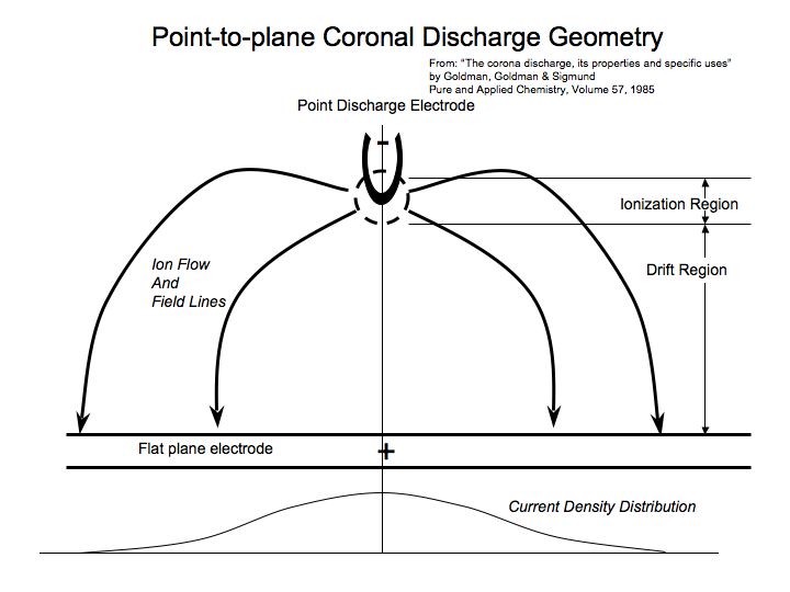
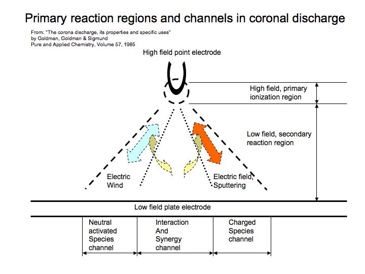
Corona discharge will produce dark current by generating the electrons and ions in a current flow that has a particular geometry. The glowing region that halos around the point electrode is where primary ionization occurs. The charged species then enter a ‘drift’ region where they follow the electric field, but are dispersed by charge repulsion in a spray, like a wonky shower-head.
It’s in this region secondary ionization occurs. If electrons/ions have enough oomph from the electric field, the secondary reactions will continue to occur, maintaining a current to the plate electrode. If not, they recombine with positive ions and neutralize, extinguishing the current.
The center of the coronal discharge is more energetic and isolated from interaction with surrounding particles of opposite charge, so more often cascade into avalanches. Closer to the edge of the discharge, weaker reactions manifest in transfer of momentum and heat between the ions and neutrals. This causes a current density distribution, as shown by the curve at the bottom of the above diagram. The current segregates into channels oriented to the distribution.
The geometry in a negative corona is three concentric regions of emission. The inner region, corresponding to the peak distribution of charge density, is ionizing plasma where high energy primary electron-neutral collisions avalanche. The intermediate ring is a non-ionizing plasma where electrons collide with neutral oxygen and water vapor with insufficient energy to avalanche, but produce a plasma of primarily negative ions that drift to the flat plate electrode and complete the circuit. The outer region is a flow of negative ions and sparse electrons known as the unipolar region.
These regions correspond well with the anatomy of a super-cell, assuming charge accumulates around, or near the central updraft that breathes life into the storm.
The Ionizing Plasma Region…
Directly beneath the core of the corona, avalanches can be energetic enough to establish sputtering arcs. We see it as negative cloud-to-ground lightning, which observations concur, happen around the updraft and with a frequency regulated by the updraft speed.
The Unipolar Region…
The uniplolar region is the outer ring of the corona. It’s not a plasma, but is composed of a low density of negatively charged ions drifting towards the plate electrode, transferring energy primarily as heat and momentum rather than electrical current. Momentum transfer manifests as downdraft winds by the process of electrokinesis.
Electrokinesis is the transfer of momentum from the charged particles to the surrounding neutrals, creating an ‘electric wind’ that moves the bulk fluid along the electric field. Air ionizers and blade-less fans work by electrokinesis, by partially ionizing air in the same fashion, with a coronal discharge.
In humid air, ions will also be hydrated causing selective water transport. Therefore, unipolar drift manifests in a thunderstorm as the forward (FFD) and rear flanking (RFD) downdraft winds, rain and hail.
The Non-ionizing Plasma Region…
The intermediate channel of non-ionizing plasma generates ions at low energy that precludes avalanche, but carry current as these ions drift to the plate. If the ionization rate exceeds the rate of recombination, the plasma will build a tendril (actually called a streamer, but we’ll use the term tendril to distinguish it from a lightning streamer) from the point electrode to the plane electrode (earth) pushing the plasma generating ionization region ahead of it, and drawing behind it a cloud of cold plasma. When this plasma hits the plane electrode a cathode spot is produced, and the electric field redistributes along the plasma channel that is created.
The Tornado…
The cathode spot on the ground (plate electrode) draws positive charge to it, dragging neutrals by electrokinesis, and creating the in-flowing winds that generate a vortex. This is the moment of touchdown, as charged air and dust flow in and spiral upwards around the invisible plasma tendril.
The action is analogous to the lightning bolt leader and positive ground streamer that meet to create a channel for arc discharge, only in this case the plasma channel is partially ionized, diffused with predominately neutral species. Its energy and charge densities are too low to make an arc, so it forms a complex plasma channel called a Marklund Convection.
Marklund convection, showing diffusion of neutral air away from current tendril (blue arrows) creating low pressure. Plasma drift (green arrows) draw positive ions at ground level, creating inflowing winds to the point of contact with the plate electrode.
Rotation is a natural consequence for two reasons. Neutral air is diffused away from the Marklund current creating low pressure. But positive ions near the ground drag air, dust and debris to the ground contact and create in-flowing winds and a sudden change in direction up, and around the tendril. The meeting of these opposing winds is, by definition, a vortex.
But current in plasma will itself rotate, taking a helical path as it interacts with the magnetic field around it. The appearance of a tornado is precisely what one would expect from such a current. Increasing current flow “spins up” the tornado.
It forms an inner spiraling negative current to ground and an outer spiral of positive ionic wind flowing up to the source of coronal discharge.
Because the tornado is a cold, partial plasma carrying a significant mass of neutral air and dust, it can be pushed by winds to create a slanted, or even kinked path, and travel away from it’s point of origin.
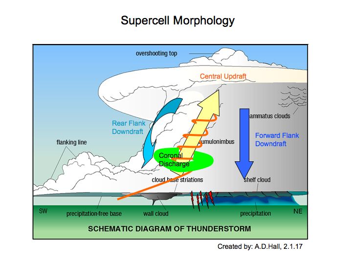
Now let’s return to the storm that most often creates tornadoes. Super-cell morphology provides all the effects of corona discharge. The super-cell has distinct regions of updraft and downdraft winds (electrokinesis), rain and hail (water transport) and sputtering arcing discharge (lightning) which we discussed earlier, forms around the central updraft.
Evidence…
If tornadoes are caused by coronal discharge generating a Marklund convection current from cloud-to-ground, what are some tell-tale signs?
Wall clouds…
One piece of evidence may be the wall cloud. Wall clouds form before a tornado in typical supercell evolution. It will develop rotation and sometimes its clouds can be seen to rise and fall in an agitated manner. Puffs of low level clouds are drawn to it below the main cloud base.
It creates a vertical wall of cloud that is incongruous to the general slant of the storm cloud and winds in-flowing to it.
This may be evidence of the vertical orientation of the electric field created by the coronal discharge and ions transported down with moisture. The electric field doesn’t pay attention to the wind.
The funnel cloud doesn’t always emerge from the center of the wall cloud, as shown in most consensus science diagrams. The tornado funnel often appears along the edges of the wall cloud, or from the surrounding clouds.
This is because the tendrils of current are mobile on the negative electrode and can wander. They can also multiply, creating several tornadoes.
Characteristic of parallel currents, multiple tornadoes stand off from each other as if repulsed like two parallel wires flowing current in the same direction. Rare occasions when tornadoes seem to merge, it may be that one simply dies as the other steals it’s current.
The sudden disappearance and reappearance of tornadoes, and the reported skipping, or lifting they seem to portray, are likely caused by pulsating current from an unstable coronal discharge that weakens until recombination steals the current, and then revives when the rate of ionization again overcomes the rate of recombination and a complete circuit to ground is reestablished.
Tornadoes and lightning…
As mentioned earlier, lightning frequency is highest around the central updraft and increases in frequency with the strength of the updraft winds. The central updraft of warm moist air carries positively charged ions and dust particles into the center of the storm. A negative corona might be expected to form around this updraft, attracted to the positive current generated, excited by the electric field and collisions with neutral atoms.
The physics of coronal discharge studied in the lab is generally done with point, or wire electrodes that have a constant position and shape. An electrode formed in the clouds probably forms an amorphous ring structure around the in-flowing central updraft, where charge densities can migrate.
When a tornado forms, it’s been noted that cloud-to-ground lightning frequency diminishes until the tornado dies, and then it picks-up again to the baseline level. This is evidence the electric field has re-aligned along the Marklund convection in the non-ionizing plasma region, sapping energy from the ionizing plasma that manifests lightning and migrating it to the outer portion of the ring.
Sights, smells and sounds…
Tornadoes are formed by a cold plasma, dark current, so light emissions aren’t evident, at least below the clouds. Storms that produce tornadoes are often characterized by a greenish tint in the clouds, however. The green tint is excused by many scientists as a reflection of city lights, and their search for green-tinted city lights continues. The green glow of a coronal discharge internal to the cloud formation explains the green tint.
Luminosity in the clouds and the funnel are also reported. Consensus science blames this on misidentified sources of light from lightning, city lights, or flashes from downed power lines. Some of it no doubt is, but some of it is likely the effect of coronal discharge. Lightning flashes don’t make a continuous glow.
Ionized oxygen can recombine to produce ozone, which has a distinctive chlorine-like “gassy smell”. As Mr. Keller’s close call with the mouth of a tornado attests, a “gassy smell” was present.
Mr. Keller also reported he heard hissing sounds from the multiple vortex tendrils at the base of the funnel. Funnel clouds and small tornadoes are known to produce harmonic sounds of whistling, whining, humming, or buzzing bees, like electricity. As ozone is liberated it produces such a hissing sound.
Energized transmission lines subject to over-voltage conditions produce all of these same effects: faint luminescent glow, ozone production and it’s accompanying hiss and smell. It’s cause is coronal discharge.
Tornadoes also produce identifiable infra-sound. It’s inaudible to the human ear, but it can be felt. It can produce nausea, agitation and body heat… not that a tornado really needs infra-sound to do that.
Lightning is seen internal to the funnel, again as reported by Mr. Keller. These are likely a form of cloud-to-cloud discharges, between the counter-flowing positive and negative currents in the Marklund convection.
Tornadoes are seen to have an inner and outer column, although this is disputed by consensus scientists as another illusion. The inner column, however, is seen if the outer dusty sheath dissipates, or is blown away. This is consistent with the double wall formed in a Marklund convection.
Double wall – an inner tube with an outer sheath of dust can be seen.
There goes Aunt Em…
A good friend who had the misfortune of being in a tornado, said he was momentarily lifted from the bathtub he was hiding in because he was weightless. He swears no wind was lifting him – he was simply weightless.
Stories from other survivors also report the sensation of momentary weightlessness, floating as if no wind was pushing. This is likely because of electrokinesis.
At ground level, the accumulation of positive charge beneath the influence of the electric field from the storm may be charging items, including people and lending them an attraction to the negative electrode overhead.
Perhaps this explains other odd events reported. For instance a house demolished, yet a table sits with a glass of water in the middle of the carnage untouched. Maybe if you don’t want to get picked up and carried away, give yourself a negative charge. Of course, too much of that can kill you, too.
Tornadoes emit on the electromagnetic spectrum as measured at a distance by researchers. Electric fields are detected and tornadoes emit sferics, the same type of broadband radio noise lightning discharges produce.
Non-super-cell tornadoes…
So what if there is no super-cell? How do all the other vortex phenomena form – landspouts, waterspouts, gustnadoes and dust devils, and how are they related.
By the same mechanism proposed here for the super-cell tornado, only in lower energy form.
Funnel clouds, which never result in a touchdown are a tendril of Marklund convection current that begins to recombine faster than it generates ions, and it dies. Landspouts, gustnadoes and waterspouts all begin with a surface disturbance – a vortex without a cloud, or at least not one showing a wall cloud, or rotation.
These may be evidence of ground contacts of the first pulse of the tendril, stimulating the ground vortex to initiate the tornado. The lack of wall cloud, rotation, or in the case of a dust devil, no clouds at all, are because the electrode is simply invisible. A dark discharge from an amorphous collection of charge in an electric field wouldn’t necessarily glow, or generate a condensation funnel.
A powerful thunderstorm creates a charged environment and elevates the electric field, regardless of whether it reaches super-cell proportions. With no organizing rotation in the clouds, the corona may very well be more like a plate electrode than a point, spread out across the sky. In this case, barrier discharge which we discussed earlier, may be closer to the mechanism that shoots tendrils without a rotating cloud overhead. Even in clear weather, thermal convection would create an updraft that could generate a diffuse corona.
This comports with the observations of twisters of all kinds, including dust devils and spouts which are seen to begin on the ground. Or water – in the case of a waterspout – where documented evolution begins with the mysterious “dark spot” on the water.
In theoretical research, not many people are even looking for electromagnetic influences except with respect to lightning. Several surveys have attempted to gain electrical data. Balloons, drones, airplanes and rockets, people in armed vehicles and stationary sounding platforms of various kinds have been deployed to take readings on tornadoes.
The extreme winds, physical danger and uncertainty in pre-positioning instrument arrays has defeated many attempts. As a result, science is relying on chasers, doppler radar and interferometers to get detailed information on wind speeds, pressures, temperatures and other physical parameters, but not so much about the ions and electric field.
Cold plasma with only a percent, or so of ionization may remain below the sensitivity of their instruments. Especially on the ground during tornadogenesis – they either arrive to late, or don’t live to tell about it. Airplanes have flown through storms and mapped clouds of electrons and ions, so we know vast sheets of charge accumulate up there.
Waterspouts were examined for electric fields. The researchers didn’t detect an unusually strong field and concluded electricity had no significant influence. There is always an electric field. Perhaps a waterspout doesn’t require as high a voltage. After all, salt water in particular, is composed of easily ionized constituents. More likely, the scientists didn’t get there on time to record the initiating pulse of the tendril, when the highest current and realignment of the electric field occurs.
We live on an Electric Earth. Weather, climate and even the land forms display it, we just need to learn how to recognize it. So, we’ll look deeper into the super-cell next time, because no one else seems to recognize it’s a thermopile!


 You can call this simple, deductive reasoning. It only takes 1% of neutral air to be ionized for it to behave as a plasma. A billion-trillion electrons has to be concentrated in the cloud more than that before it can spit a thirty-thousand amp, sixty-thousand degree, five kilometer long column of fire. Lightning genesis requires a plasma, because that is what forms the “electrode” in the sky. But you’ll never hear that from NOAA.
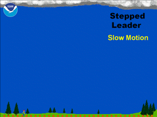
 Each layer of air in a storm has different temperature, humidity, pressure and velocity, transporting different phases of water at different partial pressures, which means the conductivity of the air is changing too. This effect we discussed already as the cause of the thermoelectric engine in the thunderstorm.
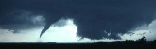
 No one fully understands tornadoes. Scientists and weather nerds chase them all over the Midwest every spring; they can’t hide. So what’s the mystery?


 If you want to make a whirlpool fast, put the spoon all the way down and stir at the bottom of the bucket. Then it forms quickly, like opening a drain. To ‘descend’, the vortex needs to be pulled down by the low pressure created by centrifugal effects of the rotating water around it. If the bulk body of water around the vortex isn’t rotating, the funnel loses coherency and dissipates.
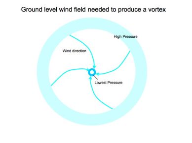
 Another theory proposes that the vortex is drawn to the ground when a descending column of air and rain wraps around a funnel cloud.
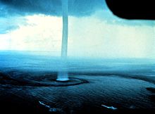
 Did they see one tornado fluctuating in strength, or two vortexes in sequence? The disappearance and reappearance is so rapid it is hard to imagine the atmospheric dynamic that would cause it.
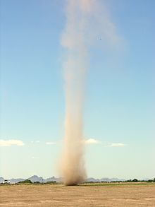
 Updraft winds don’t produce much lightning until they reach 10 to 20 mph. Then strike frequency escalates with updraft speed. From 20 to 50 mph wind speeds, lightning frequency might be 5 to 20 strikes per minute, whereas above 90 mph, the flash rate can exceed one strike per second.
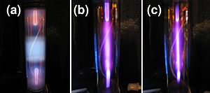


 The geometry in a negative corona is three concentric regions of emission. The inner region, corresponding to the peak distribution of charge density, is ionizing plasma where high energy primary electron-neutral collisions avalanche. The intermediate ring is a non-ionizing plasma where electrons collide with neutral oxygen and water vapor with insufficient energy to avalanche, but produce a plasma of primarily negative ions that drift to the flat plate electrode and complete the circuit. The outer region is a flow of negative ions and sparse electrons known as the unipolar region.
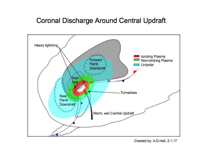 The Ionizing Plasma Region…
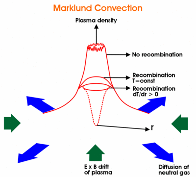


 The funnel cloud doesn’t always emerge from the center of the wall cloud, as shown in most consensus science diagrams. The tornado funnel often appears along the edges of the wall cloud, or from the surrounding clouds.
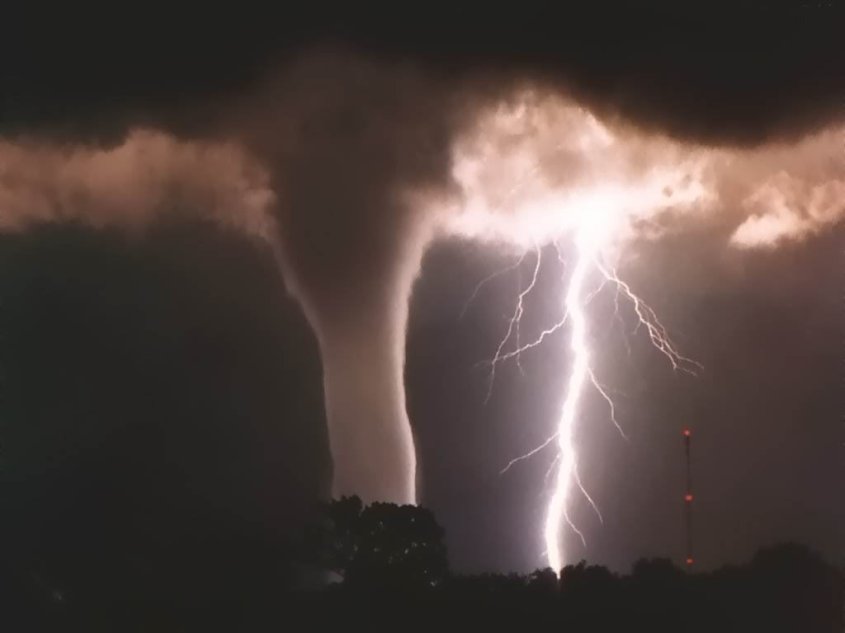
 Mr. Keller also reported he heard hissing sounds from the multiple vortex tendrils at the base of the funnel. Funnel clouds and small tornadoes are known to produce harmonic sounds of whistling, whining, humming, or buzzing bees, like electricity. As ozone is liberated it produces such a hissing sound.
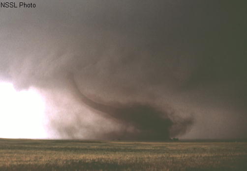
 So what if there is no super-cell? How do all the other vortex phenomena form – landspouts, waterspouts, gustnadoes and dust devils, and how are they related.